Year 1500-1599 AD
1564: The Nevatters of Mallorca
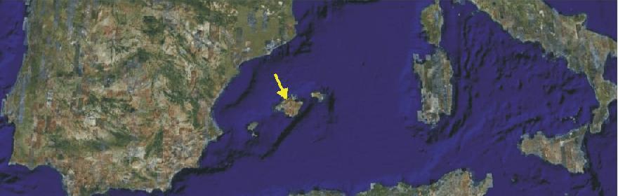
Satellite picture showing western Mediterranean Sea with Mallorca (arrow). Source: Google Earth
In
1564 the concept of nevater or snowman was fashioned in
As climate was cooling
during the first part of the Little Ice age the
amount of winter snow increased in the mountains of
The nevaters therefore constructed special cases de sa ne, or snow houses, at high altitudes. These snow houses had a special roof construction, which insulated efficiently against warm outside air during spring and summer. Each winter the nevaters filled the houses with compacted snow from the surroundings terrain, and the following summer the snow (now turned partly into ice) was transported to the lowlands. In the year 1699 people on the island Gran Canaria west of Africa would follow suit, beginning to collect snow for cooling purposes.
On Mallorca, the nevaters for long time had a hard, but respected, work. First as late as 1927, the combination of warming following the end of the Little Ice Age and the invention of electrical refrigerators brought an end to the activity of the nevaters.
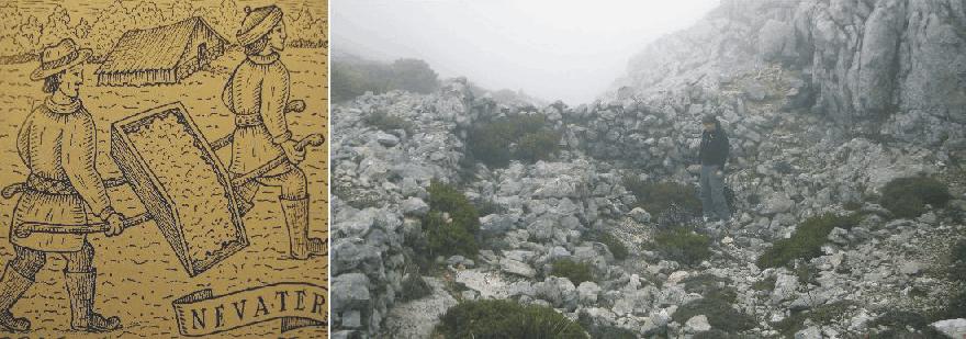
Left: Nevaters
at work in Mallorca, transporting snow to a snow house in Mallorca. Right:
Remnants of a snow house at 1250 m asl., shortly below the summit of Masanella 1349 m asl., 30 October 2007. Note
person for scale.
Click here to jump back to the list of contents.
Storms
became frequent in
The
large inland sea
The
storm known as All Saints Floods 11-12
November 1570, however, stand out as a very extraordinary event. This storm
affected most of the
Click here to jump back to the list of contents.
1576-1578: Martin Frobisher attempts to find the Northwest Passage
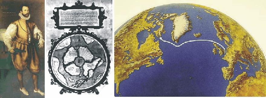
Sir Martin Frobisher painted by Cornelis Ketel in 1577 (left). World map used by Frobisher on his first voyage to the Arctic, produced 1569 by the geographer Geraldus Mercator (centre). The map indicates the existence of a broad channel between the New World (North America; lower left) and a continent with four big river systems in the centre of the Arctic Ocean. Frobisher's route from England to Baffin Island (right).
Sir
Martin Frobisher (1535-1594) was
an English seaman who became known for his three voyages to northeastern
In 1576,
at last, Frobisher had gained the necessary funding for his project. He managed
to convince the English merchant consortium the Muscovy
Company, which
previously had sent out parties searching for the
With
the help of Micheal Lok, the Muscovy Company's director, Frobisher was able to
raise enough capital for three small ships: the Gabriel and Michael, of about
20-25 tons each, and a pinnace of ten tons, with a total crew of 35. He set sail
for the
New World
on June 7, 1576. In a storm, however,
the pinnace was lost, and the Michael was abandoned, but on July 28, the Gabriel
sighted the coast of
Frobisher
landed on
During
the following year, 1577, a second and much bigger expedition was prepared. The
English Queen now was very supportive, and sold the Royal Navy ship Ayde to the
expedition (the Company of Cathay) and provided £1000 to cover the expenses of
the expedition. The Company of Cathay was granted a charter from the crown,
giving the company the sole right of sailing in every direction but the east.
Frobisher himself was appointed high admiral of all lands and waters that might be
discovered by him.
With
the three ships Ayde, Gabriel and Michael the expedition left on 25 May
1577
with 150 men, including miners, refiners, a number of gentlemen, and soldiers. Hall’s
Island at the mouth of
The following time was spent in collecting ore, and only little was done in the way of geographical discovery. There was parleying and some skirmishing with the Inuits, and futile attempts were made to recover the five men captured during the first expedition. A couple of Inuits were taken prisoner and brought back to England for display and study.
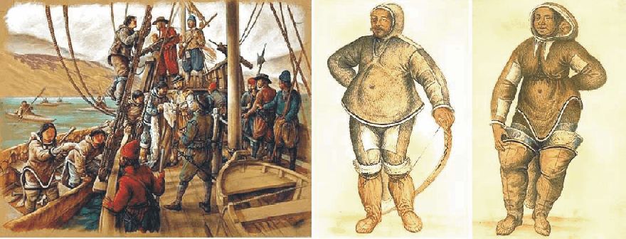
Contact between Martin Frobisher's expedition and the Inuits of Baffin Island (left). Drawings of two Inuits brought back to England (centre and right).
The
return journey was begun on 23 August 1577, and the expedition arrived back in
The
third expedition left Harwich on 30 June 1578, with no less than fifteen vessels.
June 20
Some
attempt was made at founding a settlement, and a large quantity of ore was
shipped. A successful settlement, however, was prevented by dissension and
discontent. On the last day of August, the fleet set out on its return to
Martin
Frobisher still proved interested in economical aspects of life, and later as an
English pirate collected riches from French ships. He was later knighted for his
service in the dispersion of the Spanish
Armada in 1588, under the supreme command of Sir Francis
Drake.
Click here to jump back to the list of contents.
1588: The Spanish Armada destroyed by storm
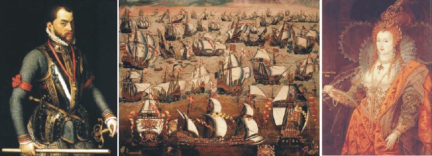
King Filip II of Spain (left).
The Spanish Armada assembling
at Lisboa, Portugal, in May 1588 (centre). Queen Elizabeth I of
King Filip II ruled
King
Philip II initially had sought an alliance with the
King
Philip II at the same time had an ongoing conflict with Dutch rebels. The Dutch
rebel leader William I, Prince of Orange, was outlawed by Philip and
assassinated in 1584 after Philip had offered a reward of 25,000 crowns to
anyone who killed him. The Dutch resistance forces however continued to fight
on, using their substantial naval resources to plunder Spanish ships and
blockade the Spanish-controlled southern provinces. When
The large Spanish army standing
in the
The Spanish Armada, also known as
the Invincible Armada, was assembled during the spring of 1588. In total 130
ships with 30,000 on board were under command of the Duke of Sidonia, Medina
Sidonia. The fleet set sail
on 28 May 1588 with 22 warships of the Spanish Royal Navy and 108 converted
merchant vessels. The intension was to sail north to the
English
fleet under command of Sir Francis Drake was assembled at Plymouth, awaiting news of Spanish movements. The Spanish Armada was, however,
delayed by adverse weather and did not reach
During the period 20-26 July 1588 several sea battles developed in the Channel region between the Spanish Armada and the English Navy, none of which were decisive. A major problem for the Armada was the lack of secure harbours, where their large ships could obtain supplies of water and other provisions. After all, they had already been at sea for two months. Also the lack of good lines of communication between Philip II and his two commanders at land and sea, respectively, contributed to the awkward situation for the Spanish fleet.
On
the evening of July 27 the Armada was anchored off
In
the shallow waters, the smaller English ships had superior manoeuvrability,
and closed in for battle while maintaining a position to windward (upwind).
Having the windward position enabled the English ships to fire damaging
broadsides into the heeling enemy ships below the water-line. Eleven Spanish
ships were lost or damaged during this action.
The
next day the wind turned southerly, enabling Medina Sidonia to move the Armada
north, into the
Off
the coasts of
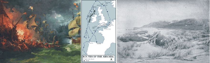
The Spanish Armada being attacked by English fireships in the night between 27 and 28 July 1588. Oil painting by Philippe-Jacques de Loutherbourg (left). Route taken by the Spanish Armada May-August 1588 (centre). Spanish ship wrecked on the west coast of Ireland August 1588, Illustration from The Art Gallery Illustrated (right).
From an official English
political point of view the outcome was a major triumph for the English Navy and for
Sir Francis Drake. In reality it was a climate-induced disaster for
From a meteorological point of
view the strong westerly and north-westerly winds suggest a major storm centre travelling
across
This British newborn naval sea
dominance was going to be the backbone in the developing
Click here to jump back to the list of contents.
1520-1600 AD: The Tudor inflation
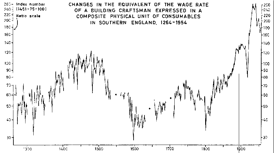
The index of the purchasing power of builders’ wages in southern England over six centuries (Figure 3 in Brown and Hopkins 1956).
The
profound check on population pressure brought about the Black
Death, and sustained by subsequent bouts of the plague, reduced the pressure
on agricultural resources in Europe for some 150 years (Burroughs,
1997). Although the fifteenth century was not without climatic hardships
(the 1430s being a decade featuring many savage winters in Europe; Lamb
1995) and harvest failures, the recorded incidence of famines was lower than
in the late thirteenth and early fourteenth centuries.
The
relative abundance of the fifteenth century is excellently illustrated by the
comprehensive work by Sir Henry Phelps-Brown and Sheila Hopkins on wages and
prices in southern England (Phelps-Brown and
Hopkins 1956).This shows (figure above) that the purchasing power of wages,
as represented by those paid to building craftsmen, rose in the second half of
the fourteenth century and remained at high levels until the first decades of
the sixteenth century. They then fell steadily to reach a nadir in 1597, the
year of Shakespeare's Midsummer
Night’s Dream, and then rose very slowly until a more rapid rise
in the early part of nineteenth century. However, the purchasing power of wages
in southern England did not return to fifteenth century levels until late in the
second half of the nineteenth century.
There
are a number of occasional drops in the wage index between 1400 and 1520,
notably in 1439 and 1482, but the overall picture is one of underlying price
stability during this period. This makes the fivefold rise in prices that
started in 1520 so intriguing to economists. Analysis of prices and wages in
France has produced a similar picture.
Known
as the ‘Tudor Inflation’, the rise in prices - and the correspondingly drop
in wage purchasing power - during the sixteenth century has been variously
attributed to demographic pressures and to the influx of gold and silver from
the Americas which inflated the money supply in England. Some has suggested this
development to represent a Malthusian crisis, the effect of a rapid growth of
population impinging on an insufficiently expansive economy (Phelps-Brown
and Hopkins 1956).
Whatever
the reason for the Tudor inflation, this development lead to the so-called Mid-Tudor
crisis between 1547 (the death of Henry
VIII) and 1558 (the death of Mary
Tudor), where English government and society were in imminent danger of
collapse in the face of a combination of weak rulers, economic pressures, a
series of rebellions, religious upheaval in the wake of the English
Reformation, and other factors.
Among
other factors one especially tend to stand out: The Tudor inflation coincided
with a marked cooling of the climate (The Little Ice Age), especially well
documented in NW Europe. The GISP2
ice core from central Greenland adds support to this notion (figure below).
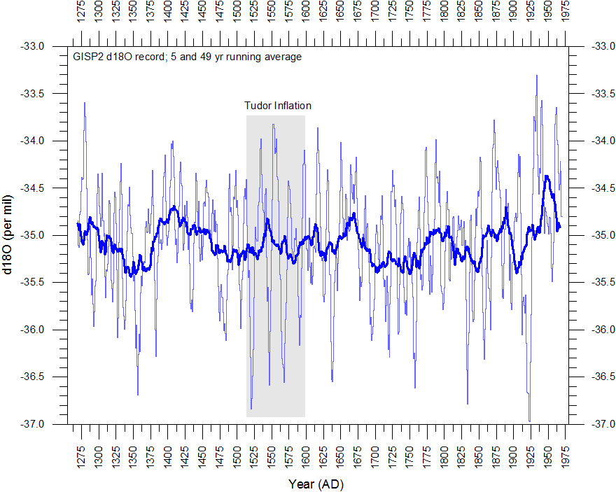
Greenland GISP2 annual delta 18O values. The thin line shows the 5-yr running average, and the thick line represent the 41-yr running average. The period of the Tudor Inflation is indicated by grey colour.
The Greenland ice core data suggests that, although on average not being quite as cold as the later 1650-1750 period, the period of the Tudor Inflation was indeed characterised by recurrent very cold years (spikes indicating low 5-yr average d18O values). In contrast, the preceding period 1390-1520, corresponding to the period of high purchasing power of wages in southern England, was characterised by an absence of such cold spikes. Presumably, recurrent 2-3 cold years in a row during the period of Tudor Inflation may have induced recurrent harvest failures and from this, rising prices.
Click
here to jump back to the list of contents.