Year 1800-1899
-
1815: The year without summer. The Tambora volcanic eruption
-
1817: Royal Society of London on the retreat of Arctic sea ice
-
1830-1850: Famine and depopulation of the Scottish Highlands
-
1840: Arctic explorations becomes a national obsession in
-
1851: Jakobshavn Isbræ in West Greenland reaches LIA maximum and begins to retreat
-
1854: The Crimean War, beginning of systematic meteorological observations
1800-1812:
Napoleons new Europe and scientific progress 
The political boundaries in Europe at the end of the 18th century and the constitutional arrangements within them were largely the legacy of medieval attempts at creating a pan-European empire. Germany was broken up into more than 300 different political units, ruled over by electors, archbishops, dukes, landgraves, city councils, counts, imperial knights, etc. What is now Belgium belonged to the Habsburgs and was ruled from Vienna, while Italy was divided up into 11 states, most of them ruled by Austrian Habsburgs or French and Spanish Bourbons. The Holy Roman Empire of the German Nation included Czechs, Magyars and half a dozen other nationalities. Poland was divided into three regions, ruled from Berlin, Vienna and St. Petersburg, respectively. Especially the Polish situation was to have consequences for the near future in Europe.
Between 1801 and 1806, following his victories over Austria and Prussia, Napoleon transformed the political, social and economic climate throughout the German lands. Each annexed territory was reorganised along the lines of French Enlightenment thought, rulers were dethroned, the Holy Roman Empire was dissolved, imperial counts and knights lost their lands, nonsensical borders were removed, caste privileges and other restrictions were abolished, and in their place came new institutions mounded on the French Pattern. The ending of feudal practices gave agriculture a boost, and the removal of tolls and frontiers liberated trade. The confiscation of church property was followed by the building of schools and the development of universities. Napoleon became very popular in most of Europe with the middle class, peasants, Jews, as well as with progressive intellectuals, students and writers. Many new scientific ideas and hypotheses were put forward in this new atmosphere of freedom.
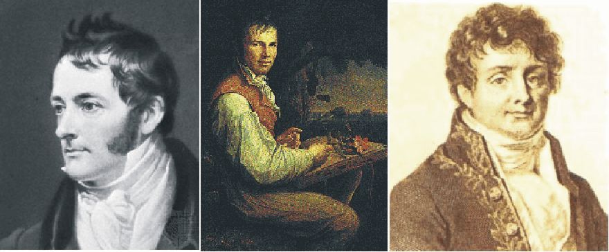
William
Henry
With
the victories of
Science
in many other countries in
One
example of this is the English chemist William Henry (1775-1836), who in 1803
described his results with experiments on the quantity of gases (e.g. CO2)
absorbed by water at different temperatures and under different pressures. His
results are known today as Henrys law. This fundamental law among other
things describes how the solubility of CO2 in water decreases with
temperature.
Shortly
after this, in 1816 and again in 1827, the French mathematician and physicist
Jean Baptiste Joseph Fourier proposed the hypothesis that the atmospheric
temperature would depend, among other things, on the amount of atmospheric CO2.
This resulted in the first broad scientific interest for CO2 as a
chemical substance, and various scientists began measuring the actual
concentration of atmospheric CO2. This was seen to vary over time,
and using Henry's law, such variations were explained by small variations in the
sea surface temperature, controlling the solubility of CO2 in ocean
water. Also various geological and biological processes were considered as being
potentially important for the variable atmospheric CO2 content. In
addition to proposing the CO2 hypothesis, Jean Baptiste Joseph
Fourier actually became best known for initiating the investigation of
mathematical Fourier series and their application to problems of heat flow.
1812:
Background for Napoleon's Russian campaign
Also
in 1806, Napoleon won a conclusive battle against
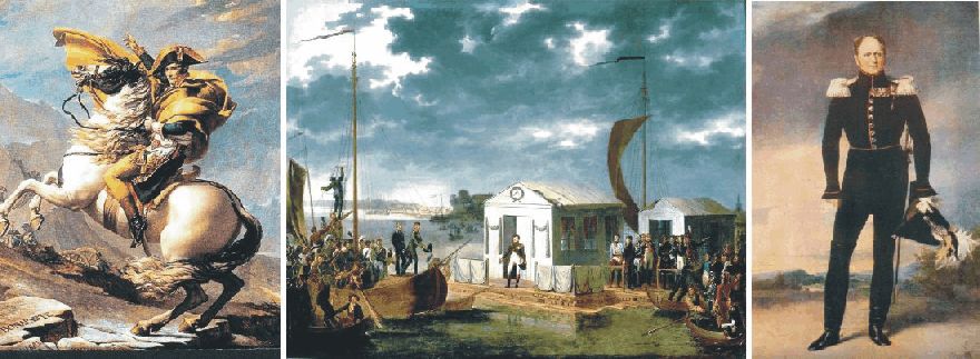
The two emperors
Napoleon (left) and Alexander I (right) negotiating the Tilsit Treaty in a pavilion set up on a raft in the middle of the
Niemen River, beginning 25 June 1807.
In
November 1806 the Holy Synod of the Russian Orthodox Church issued a
denunciation of Napoleon, accusing him of conspiring with evil people against
the Christan Faith, due to Napoleons declaration of his regard for Islam. Russia
therefore launched a military crusade against him. This initiative was cut short
by Napoleon routing the Russian army at Eylau (January 1807) and at Friedland
(June 1807). Tsar Alexander I of
Cracks in this alliance,
however, rapidly began to show. Especially Napoleon's creation of the Grande Duchy of
Caught
up by the internal dynamics of this development, Napoleon decided to strike
first, and began a relentless build-up of forces through the autumn and winter
of 1811 and into the spring of 1812. The army Napoleon was assembling would be
large by any scale, including soldiers from almost every nation of
Click
here to jump back to the list of contents.
1812:
Napoleon's Russian summer campaign
In
western
The
Russian army was no happier than the French, and its troops were in a state of
dejection as they retreated towards
The battle of Smolensk had also demonstrated the unpleasant fact to Napoleon, that the individual Russian soldier did not lay down his arms even in very difficult situations. 129 years later Adolf Hitler would make the identical observation. The French were dismayed by all this. This was not how war was supposed to be. In addition, these discomforts were added to by the fact that the Russians had adopted a new tactic now that the invaders were in the Russian homeland proper. They evacuated the entire population as they retreated, leaving towns and villages deserted and burnt down. It became increasingly difficult for the French army to find provisions.
Napoleon realised that he could not stop where he was, and as he would not retreat for political reasons, he could only advance in the hope of eventually obtaining a decisive military victory over the Russians. If not before, the Russians would surely make a stand in defence of their old capital Moscow. Based on existing knowledge on climate in western Russia, Napoleon at that time expected at least two months of decent campaigning weather ahead.
The mood at Russian headquarters was hardly better, even though the general situation was changing in their favour. The retreat was a good deal less orderly than before, and the Russian armies were now leaving behind them a trail of abandoned wagons and dead or dying men and horses. Like the French, the Russians were disturbed by the inhumane turn the campaign had taken. The ongoing retreat meant that discipline were fast breaking down, and everybody was on the lookout for traitors. All this was having a detrimental effect on the army and Barclay's authority.
In St. Petersburg Tsar Alexander found the general mood depressingly defeatist, and decided that the Russian army needed a new commander instead of Barclay. He was hard pressed by the public opinion to choose Field Marshal Mikhail Ilarionovich Kutuzov as Barclay's successor. Alexander himself was not to happy about this, as he considered Kutuzov both immoral and incompetent. His sister Catherine, however, urged him to bow to the inevitable, and Kutozov was appointed 20 August 1812. Kutuzov declared that he was going to save Moscow, and set off to find his headquarters.
After assessing the state of the Russian army Kutuzov suddenly felt that he could not face Napoleon, whose strength now was gauged at 165,000, down from the original 450,000. The Russian summer had taken its toll. Kutuzov therefore decided to continue the retreat initiated by Barclay two months before. Perhaps he also suspected Napoleon to be a superior general to himself. On 3 September Kutuzov inspected defensive positions found near the village of Borodino, about 100 km west of Moscow. Here he was going to make a stand.
Kutuzov took up entirely defensive positions without any tactical possibility of gaining the initiative. Luckily for him, Napoleon had just caught a cold with an associated attack of dysuria, and was in anything approaching his usual form. In fact, Napoleon was going to deliver probably the worst performance of his entire military career. The invading French army was now down to 126,000, while Kutuzov had about 155,00 men under his command.
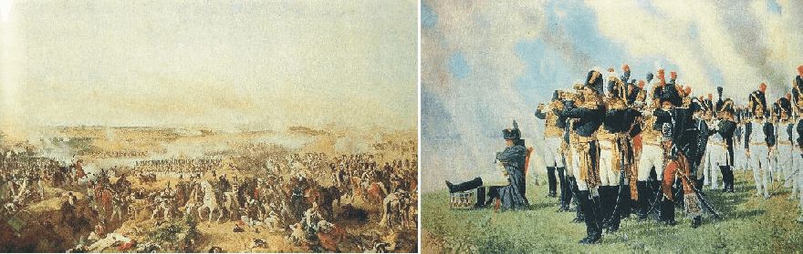
The Battle at Borodino 6 September 1812 (oil painting by Hess), with Napoleon watching from the Shevardino Redoubt (oil painting by Vereschagin).
The first large battle during Napoleon's Russian campaign began in the morning of 6 September 1812. Before this battle, both armies had lost more than half their original strength during eight weeks of Russian summer. The battle of Borodino was a hard fought battle with several Russian counterattacks, but slowly the French was getting the upper hand due to its superiority on the tactical level, and the Russian army had to retreat. The battle of Borodino was the greatest massacre in recorded history, not to be surpassed until the first day of the battle at Somme in 1916. Recent estimates give a total of about 73,000 casualties, 45,000 Russian and 28,000 French including allies.
Kutuzov's army was now in no condition to give battle on any positions, however strong. He therefore fell back to Moscow, announcing that he would fight in front of the city to the last drop of blood. In reality, he continued the retreat through the city to the consternation of the inhabitants. Kutuzov then turned south and later southwest, setting up a fortified camp for his army near Tarutino, about 120 km SW of Moscow.
Click here to jump back to the list of contents.
In the afternoon of 14 September, what was left of the Grande Armée entered Moscow. Napoleon took up residence at the Kremlin the following day. About two-thirds of the 270,184 inhabitants had left, and the remainder were hiding in their homes. Nobody with an official status was left to take care of a formal surrender and make arrangements for feeding the soldiers, as would normally be the case in a civilised war. To make things even worse, before leaving Moscow, the city commander Count Rostopchin had ordered his Police Superintendant Voronenko to burn not only the remaining supplies, but everything he could. Voronenko and his men set to work, presumably assisted by the city's criminal elements. The fire raged out of control and spread to several districts of the city. In the morning of 16 September flames were lapping around the walls of Kremlin, and Napoleon had to evacuate himself and take up residence in the Petrovsky Palace, a few kilometres outside Moscow.
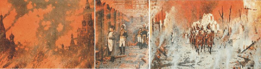
Moscow burning 15-18 September 1812. On the 18 September Napoleon returns to Kremlin after having evacuated himself to the Petrovsky Palace outside Moscow. Oil paintings by Vereschagin.
After three days the fire began to abate, and on 18 September Napoleon rode back into Moscow. Two thirds of the city was destroyed by the fire, robbing him of a wealth of material resources. And there was still no delegation formally surrendering Moscow to him. Even worse, Tsar Alexander still apparently did not understand that Russia was defeated, and therefore had no ambitions of making peace with Napoleon. It was all very frustrating.
Napoleon now had to consider taking up winter quarters in Moscow. Alternatively he would have to retreat with his back home, a move which for political reasons was difficult. So for the time being, he choose to remain in Moscow, hoping that Alexander finally would come to his senses.
Napoleon had studied the available weather information, which told him that it normally did not get really cold until the beginning of December, so he did not feel any sense of urgency. What he did not realise, was how sudden low temperatures may come if a high pressure area settles over eastern Europe, pumping arctic air masses south across Russia, where the lack of high mountains leave the whole country open for arctic air masses. In addition, he had no experience of temperature being only one factor, but that the wind strength also had to be taken into account.
Early October 1812 the weather remained to be fine and warm, and Napoleon was teasing Caulaincourt, his chief adviser, about his anxiety about the winter climate. On 13 October, however, the weather suddenly turned cold, and Moscow was covered in a blanket of thin snow. Presumably this was a meteorological surprise to Napoleon, and it rapidly made him make up his mind. The same day he declared that the army would leave as rapid as possible, and take up winter quarters further west, where well-stocked bases were at hand in Minsk and Vilna. Napoleons army left Moscow 20 October.
Click here to jump back to the list of contents.
1812:
Napoleon's retreat from Moscow
The actual armed forces at Napoleon's disposal as he left Moscow numbered no more than 95,000, and probably less. Marchal Kutuzow was still camping passively SW of Moscow, reinforcing his army to about 97,000 men. He was, however, still in no hurry to engage in regular warfare. So while Napoleon was retreating west towards Smolensk along the Moscow road, Kutuzov did not seriously attempt to cut across their line of retreat, even though he was excellently placed to do so.
The French retreat was slow, mainly due to lack of horsepower. The shortage of fodder had debilitated the horses, and they were growing too week to pull the guns and wagons. Part of the problem was that Napoleon saw himself carrying out a tactical withdrawal rather than a retreat. Therefore he refused to abandon a proportion of their guns to liberate horses and thereby save time. This determination not to loose face would cost him dear. As well as slowing their progress, all this had a demoralising effect on the French troops, marching down a devastated road, seeing only abandoned equipment, human and animal corpses. Kutuzow was still following south of the French army, but resolutely opposed to any suggestions from his generals to make an offensive move.
The good news for the French was that the weather was magnificent, and that the early snow in Moscow presumably just was a meteorological mishap. On 31 October, at Viazma, Napoleon therefore ridiculed those who had been attempting to scare him with stories of the Russian winter. The weather remained fine during the first days of November 1812, until 3 November, which was to be the last warm day. The wind turned north and the night between 4 and 5 November brought with it a rapid drop in air temperature. On 6 November the French retreat was entering a new phase. It began to snow, and in short time it lay half a meter thick on the ground. The drop in temperature had not been that great, probably not exceeding -10oC. But the French army was not used to or dressed for cold weather. There was no such thing as a winter uniform, since in those days armies did not fight in winter. The cold also provided the last straw for many of the remaining horses. The meteorological change early November 1812 had a profound effect on the whole French army.
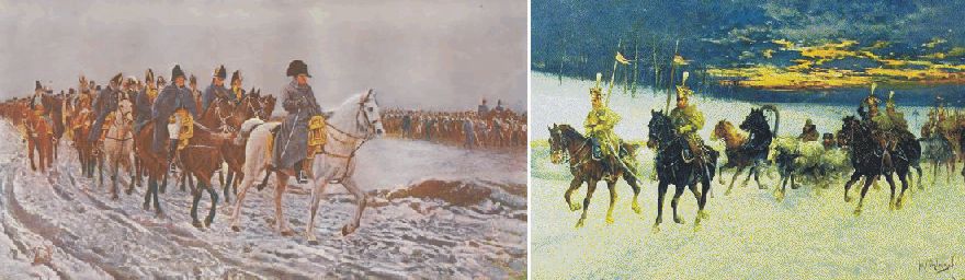
Napoleon and his army retreating across western Russia early November 1812.
Also the Russian army under Kutuzow was affected by the cold, and food and clothing was equally scarce. The war now grow even more vicious than before, and captives had become an unwelcome encumbrance to both sides. Many prisoners, French or Russian, were simply despatched with a bullet to the head.
When Napoleon 9 November reached Smolensk, the wind was still northerly and air temperatures were down to -15oC. On 14 November, they sank to -28oC. His army was now reduced to about 35,000 men. Kutuzow made some attempts at intersecting Napoleons further retreat towards Minsk, but without substantial success. 22 November Napoleon reached Tolochin, where he was informed that other Russian forces just had taken Minsk further to the west. What was left of the French army was surrounded. Napoleon, nevertheless, managed to extricate himself from this impossible situation by fainting an attack towards south, while his engineers at the same time was constructing two bridges across the frozen river Berezina, which was crossed 27-28 November.
The following two days may have been among the worst of the entire retreat. When Napoleon reached Pleshchenitse on 30 November, a temperature of -30oC was recorded be Dr. Louis Lagneau (Zamoyski 2005). Frostbite was widespread among the tired and hungry soldiers. Selfishness reached new heights. Now that Napoleon had managed to get beyond his reach, Kutuzov felt even less inclined to force the pursuit than before. Also his army was in a terrible condition. His main force, which has marched out of Tarutino 97,000 strong one month before, was now reduced to 27,000 men due to the cold, according to his own figures (Zamoyski 2005).
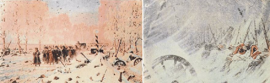
Retreat of the French army in western Russia, mid- and late November 1812. Oil paintings by Vereschagin.
On the evening of 5 December, at Smorgonie, Napoleon decided that it was time for him to go back to Paris, and take control from there. He called together his marshals and apparently apologised for his mistake of having remained in Moscow for too long. He then set off into the night. The Imperial Mameluke, Roustam, later reported that the wine in Napoleon's carriage froze that night, causing the bottles to shatter. On 6 December the temperature fell even more, reaching -37.5oC according to Dr. Louis Lagneau.
This
was the end. On 9 December the main mass of the French army turned up at the
gates of Vilnia. Vilnia, however, could not be hold, and the retreat had to
continue towards the starting point along the river Niemen. The weather
continued bitterly cold, with daytime temperatures around -35oC. The
French commander Murat realised that the line of Niemen could not be held, and
had to retreat all the way to first Kö
It was only when the French retreat finally came to a stop towards the end of January 1813 that the true scale of the disaster began to emerge. June 1812 somewhere between 550,000 and 600,000 French and allied troops have been assembled along Niemen. Only about 120,000 came out of Russia in December 1812, including substantial reinforcements received after the invasion was launched 22 June. Presumably at least 400,000 French and allied troops died during the campaign, less than 100,000 in battle. On the Russian side is has been estimated that up to 400,000 soldiers and militia died, about 110,000 of them in battle.
The extremely cold winter November-December 1812, in combination with the previous warm summer July-August 1812 had been devastating for the whole military operation on both French and Russian side, and were to have lasting effects on Europe's political future.
The catastrophic outcome of the Russian campaign sealed Napoleon's fate. Not only did it cost him 300,000 of his best French soldiers (today this would compare to a loss of 700,000 men), but it also punctured the aura of superiority and being invincible that has been surrounding Napoleon's person. Few saw this more clearly than the German patriots in Prussia, who had been suffering under the humiliation of French dominion. On 28 February 1813 an alliance was concluded between Russia and Prussia, and two weeks the latter declared war on France.
In astonishingly short time Napoleon managed to raise a new army of 200,000 men, and defeated the combined Russo-Prussian force at Lützen on 2 May and at Bautzen 20 May, but all to no avail. Sweden joined the coalition against Napoleon and Britain contributed money. And as Napoleon's enemies grew in strength, his remaining allies began to waver. On 12 August Austria declared war on France. Napoleon responded by defeating a combined Russian-Austrian army 26 August outside Dresden. On 16 October 1813 Napoleon faced the combined forces of the new coalition at Leipzig, being outnumbered by two to one. Napoleon nevertheless held his ground for long, but finally had to fell back across the Rhine early November 1813. In the spring of 1814 he fought his perhaps most brilliant campaign against the invading armies on French soil, but was unable to do more than delay the evitable end. Paris capitulated 31 March 1814, and Napoleon was force to abdicate on 6 April, less than 18 month after leaving Moscow. He was exiled to the island of Elba off the Italian coast. One year later, on 1 March 1815, he landed in France and took power once again. On 18 June 1815 he was defeated at Waterloo by a combined British and Russian army under Wellington. Even at this final confrontation, Napoleon proved himself to be an outstanding general. The final outcome of the battle was, in a phrase used by the Duke of Wellington in describing his victory at Waterloo, "the nearest run thing you ever saw in your life" (Massie 2005). Napoleon was then exiled to St. Helena in the southern part of the Atlantic Ocean, where he died 5 May 1821.
Click here to jump back to the list of contents.
1815:
The year without summer. The Tambora volcanic eruption
The 1815 eruption of Tambora was probably the largest eruption in
historic time. About 150 cubic kilometres of ash were erupted. This is about 150
times more than the 1980 eruption of
An estimated 92,000 people were killed by the
eruption.
About 10,000 direct deaths were caused by bomb impacts, tephra fall, and
pyroclastic flows, the rest indirectly by starvation, disease, and hunger. The
eruption apparently lowered average world temperature by about 0.5-0.7°C over a
period of 2-3 years. The 1815 eruption of Tambora was followed in North America
and
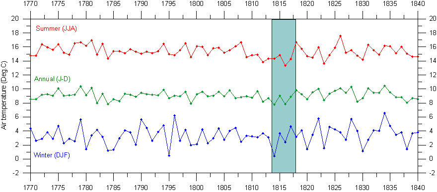
Central England temperature series 1770-1840. The length of the cooling effect of the Tambora 1815 eruption is indicated by the blue bar. These graphs has been prepared using the composite monthly meteorological series since 1659, originally painstakingly homogenized and published by the late professor Gordon Manley (1974). The data series is now updated by the Hadley Centre and may be downloaded from there by clicking here. A graph showing the entire Central England temperature series since 1659 can be seen by clicking here.
Click here to jump back to the list of contents.
1817:
Royal Society of London on the retreat of Arctic sea ice
President of the Royal Society, London, to the Admiralty, 20th November, 1817 (Royal Society of London 1817):
"It will without doubt have come to your Lordship's knowledge that a considerable change of climate, inexplicable at present to us, must have taken place in the Circumpolar Regions, by which the severity of the cold that has for centuries past enclosed the seas in the high northern latitudes in an impenetrable barrier of ice has been during the last two years, greatly abated....
.....
this affords ample proof that new sources of warmth have been opened and give us
leave to hope that the Arctic Seas may at this time be more accessible than they
have been for centuries past, and that discoveries may now be made in them not
only interesting to the advancement of science but also to the future
intercourse of mankind and the commerce of distant nations."
Click here to jump back to the list of contents.
1822-1878:
Petermann and the model of the open Arctic Ocean 
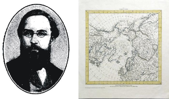
August Heinrich Petermann (left). Map of the Arctic published around 1860 (right).
August
Heinrich Petermann (1822-1878) was a German cartographer and geographer. In 1854
he was appointed as director of the geographical institute of Justus Perthes in
Gotha (Germany), and in 1855 founded the famous geographical journal Petermanns
Mittellungen, which existed until 2004.
August
Petermann’s main geographical interest was two-fold: The geography of the
interior of Africa, and that of the North Polar regions.
In 1852, August Petermann's belief in the ice-free central part of the Arctic Ocean made him propose that search expeditions for the lost Franklin expedition should sail north between Spitsbergen and Novaya Zemlya, thereby taking a shortcut to the open, navigable Polar Sea, providing easy access to the areas north of the American continent.
Petermann
was appointed as royal geographer by Queen Victoria. He later died by his own
hand at Gotha on September 25, 1878.
Click here to jump back to the list of contents.
1830-1850:
Famine and depopulation of the Scottish Highlands
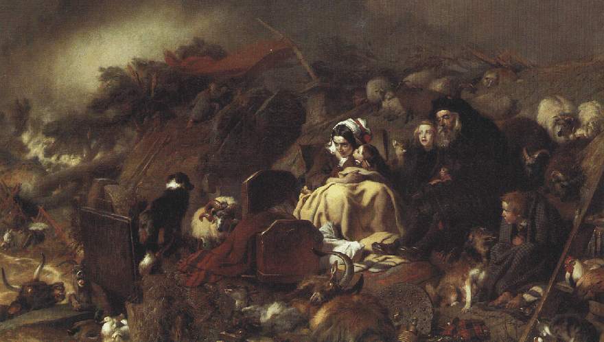
Flood in the Highlands; painting by Sir Edwin Landseer. From the 1820s Landseer painted many scenes from highland life, particularly wildlife.
For political reasons, in the 19th
century liberty was a dangerous word in
A magazine illustration from 1853 showing the loading of a ship with emigrants from the Isle of Skye, northwestern Scotland.
It was, however, the
climate-induced famine of the 1840s that started the real emptying of the
Scottish Highlands. The British Government, which had once tried to find ways of
preventing the depopulation of the
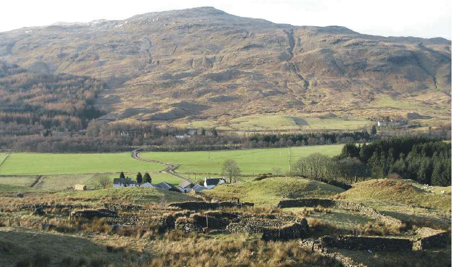
Deserted farm buildings in Trath Filland, 2 km northwest of Crianlarich, western Scotland, February 15, 2008. The location is about 200 m above sea level, and the main modern crop is grass because of the limited number of growing degree days. The former farm is located on a slope facing SW, in an attempt to maximise solar radiation in the afternoon, while fog and low clouds often dominate the meteorological conditions during the morning in this part of Scotland.
Click here to jump back to the list of contents.
1840:
Arctic explorations becomes a national obsession in
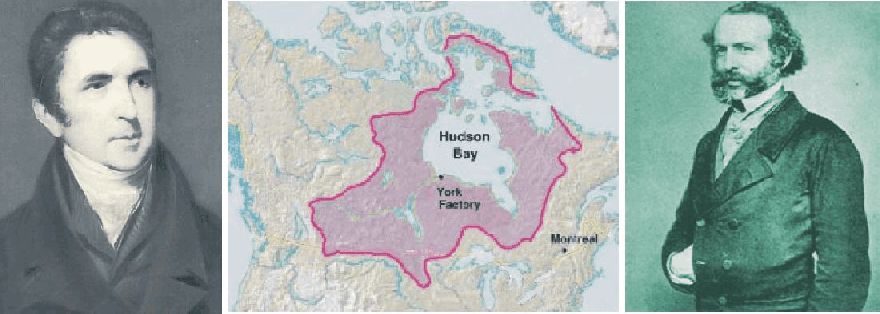
John Barrow, second secretary to the Admiralty (left). Map showing area of Canada where the Hudson's Bay Company was active (centre). John Rae, the Arctic traveller and Hudson's Bay Company doctor, who later solved the fate of the doomed Franklin expedition and found the last navigable link in the Northwest Passage.
By the early 1840s, Arctic
exploration had attained the status of a national obsession in
During the past three and a half
centuries, northern Europeans, lead by
Since the 1570s, when Martin
Frobisher identified two possible
Part of the reason for the
growing interest in Arctic exploration in
John Barrow, second secretary to
the Admiralty, therefore renewed the quest for the
Also, because the
Click here to jump back to the list of contents.
1845-1848:
The Franklin Expedition to the Northwest Passage
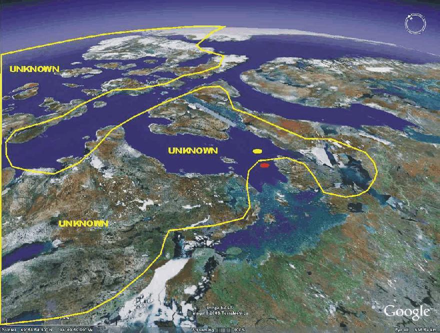
Satellite picture showing the central parts of the Northwest Passage, as known in 1845, when the Franklin Expedition sailed. Direction of view is towards northeast. The yellow dot shows where Erebus and Terror were beset 1846. The red dot shows where they were abandoned April 1848. King Williams Island is seen shortly southeast of the red dot. Greenland is seen in the far distance. Picture source: Google Earth.
In September 1843 James Clark Ross returned triumphantly with HMS Erebus and HMS Terror from a brilliant three-year voyage of exploration in Antarctic seas, during which the Ross Sea and the Ross Ice Shelf were discovered and named. Their arrival offered John Barrow a last opportunity, before his retirement in 1845 aged eighty, to mount the decisive expedition to find the Northwest Passage.
The Royal British Navy therefore decided to send a well-equipped Arctic
expedition to complete the charting of the
The new British expedition with John Franklin in command was
ordered to gather magnetic data in the Canadian Arctic and to complete a
crossing of the
The expedition was provided with the two sturdy navy ships, HMS Erebus and HMS Terror, just returned from their Antarctic journey. Both ships was build as so-called bomb vessels. Bomb vessels were strongly built in order to withstand the enormous recoil of their 3 ton mortars, and this made them suited to Arctic service. Both ships were equipped with converted railway twenty-horsepower steam engines that enabled the ships to make 4 knots on their own power, and also provided a novel heating device for the comfort of the crew. In addition, a mechanism that enabled the iron rudder and propeller to be drawn into iron wells to protect them from damage when in thick ice. Iron plating was added to their hulls. The expedition brought and three years preserved or tinned preserved food supplies with them. The quality of the canned soups and meat have since been reason for concern, and may have contributed to the sad outcome of the expedition. Captain James Fitzjames, was given command of HMS Erebus while Captain Francis Crozier was named executive commander and commander of HMS Terror.
Being well aquainted with Erebus and Terror from his Antarctic expedition, James Ross thought that the two ships were to big for the planned operation, and was convinced the expoedition would fail. No one, least of all Franklin himself, listened to Ross.
The Franklin Expedition set sail
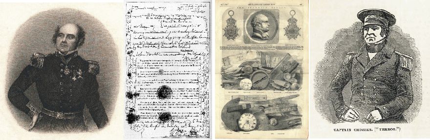
Sir John Franklin (left). The note found by McClintock in May 1859 in a cairn south of Back Bay, King William Island,
describing the fate of the Franklin Expedition until April 1848 (centre left). Relics of Franklin's
expedition brought back by John Rae in 1854 (centre right). Captain Crozier of
the Terror, Franklin's second in command (right).
The remaining part of the summer 1845 was used exploring the
Wellington Channel northwest of
Presumably
Terror and Erebus were rapidly beset in the thick ice in the southern part of McClintock Channel. Their twenty-horsepower steam engines were no match for meter-thick sea ice. Not surprisingly, the multiyear ice did not melt the following summer 1847, and both ships had to be abandoned in April 1848. Sir John Franklin himself died in June 1847. A desperate attempt to walk and sail to safety in the south with smaller boats was attempted, but in vain. No members of the expedition survived.
A number of rescue expeditions were organized. The German geographer August Petermann in 1852 proposed that a search expedition should be send northwards through 'the wide opening' between Spitsbergen and Novaya Zemlya which 'probably offers the easiest and most advantageous entrance into the open, navigable Polar Sea, and perhaps the best route for the search after Sir John Franklin' (Brown 1858).
The Hudson's Bay
Company doctor John
Rae was, however, in 1854 was the first to collect evidence and information from local
Inuit’s pointing to the fate of the
Captain Leopold McClintock commanded one of the rescue expeditions and later in a book published about his voyage wrote (McGoogan 2001):
Had Sir John Franklin
known that a channel existed eastward of King William Land (so named by Sir John
Ross), I do not think he would have risked the besetment of his ships in such
very heavy ice to the westward of it; but had he attempted the northwest passage
by the eastern route, he would probably have carried his ships safely through to
Behring’s Straits. But Franklin was furnished with charts which indicated no
passage to the eastward of King William’s Land, and made that land (since
discovered by Rae to be an island) a peninsula attached to the continent of
North America; and he consequently had but one course open to him, and that the
one he adopted.
In many respects John Rae can be said to have discovered the
final link in the only
Click here to jump back to the list of contents.
1851:
Jakobshavn Isbræ in West Greenland reaches LIA maximum and begins to retreat
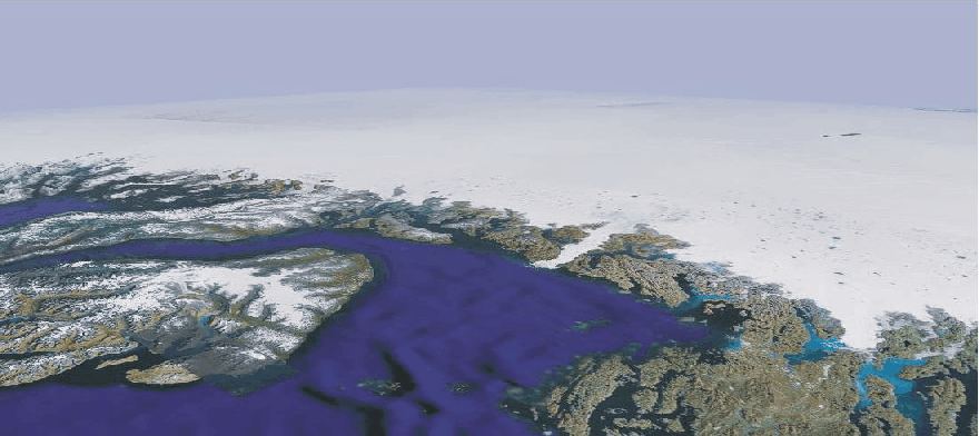
Disko Bay and Jakobshavn Isbræ, a calving outlet glacier from the Greenland Ice Sheet, seen from southwest. Jakobshavn Isfjord and Jakobshavn Isbræ is seen near the centre of the picture. Disko Island is seen to the left, and part of the Greenland Ice Sheet is seen in the background. The distance from southernmost Disko Island to the mouth of the ice-filled Jakobshavn Isfjord (Ilulissat Icefjord) is about 100 km. Picture source: Google Earth.
The Disko Bay region in central West Greenland (c. 70oN) is characterised by large outlet glaciers from the Greenland Ice Sheet (the Indland Ice). The major glacier Jakobshavn Isbræ is situated in a major subglacial valley, which can be traced inland for about 100 km (Echelmeyer et al. 1991). The water depth in the fjord reaches 1500 m in its outer parts (Iken et al. 1993).
The first thorough glaciological studies in this area were those by Rink (1853), who introduced the terms Inland Ice and ice streams. The Disko Bay was deglaciated rapidly around 10.500-10.000 years ago, in the early part of the present interglacial (Weidick 1968). When the retreating ice front reached the coastline at the mouth of the Jakobshavn Isfjord (Ilulissat Icefjord), the retreat was interrupted while the glacier front was resting on a bank near Ilulissat 200-300 m below the present sea level. Later, the glacier again retreated, and reached the modern position c. 7.000 years ago. The retreat, however, continued, and by 5.000 years before now the glacier front was east of the modern position, about 20 km east of the ice margin position in 1964 (Weidick et al. 1990).
Global cooling after 5.000 year before now resulted in significant growth of the Greenland Ice Sheet, and the resulting advance of Jakobshavn Isbræ culminated around the year 1850, during the Little Ice Age (se frontal position in the figure below). From 1851 the calving glacier began retreating, and at the end of the 19th century the glacier front was about 10 km east of the maximum position reached in 1851 (Bauer et al. 1968). The seasonal fluctuations of the glacier terminus were recorded 1879-1880 by Hammer (1883), who also described local inuit legends that the glacier-filled embayment Tissarissoq (see figure below) formerly was ice-free and used as a hunting locality. If this is correct, open water probably extented east of the early 21st century glacier front position before the onset of the Little Ice Age (Weidick et al. 2004).
Jakobshavn Isbræ is the main outlet glacier from the Greenland Ice Sheet, draining ice from about 6.5% of the total area of the ice sheet, and producing 30-45 km3 icebergs per year. This corresponds to more than 10% of the total output of icebergs from the Greenland Ice Sheet, and the Jakobshavn Isbræ is the most productive glacier in the northern hemisphere. The glacier flow velocity is also high, typically 20-22 meters per day. It is likely that the iceberg which sank Titanic in 1912 may have been produced by Jakobshavn Isbræ.
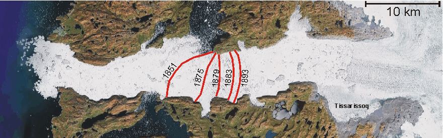
Frontal positions of calving Jakobshavn Isbræ in the latter half of the 19th century, after reaching the maximum Little Ice Age position around 1850 (Bauer et al. 1968). Between 1851 and 1893 the glacier front retreated about 10 km. The early 21st century (2001) glacier front is seen about 14 km east of the 1893 position. According to inuit legends, the embayment Tissarissoq used to be glacier-free and was used as hunting area (Hammer 1883), most likely before before the Little Ice Age glacier advance (Weidick et al. 2004). Picture source: Google Earth.
A note describing the retreat of Jakobshavn Isbræ 1893-1942 can be found here. A description of the glacier retreat in the early 21st century is found here.
Click here to jump back to the list of contents.
1854:
The Crimean War, beginning of systematic meteorological observations
The Crimean War (1853–1856) was fought between Imperial Russia on one side and an alliance of France, the United Kingdom, the Kingdom of Sardinia, and the Ottoman Empire on the other. The chain of events leading to Britain and France declaring war on Russia on 28 March 1854 can be traced to a fierce disagreement of whom was going to have "sovereign authority" in the Holy Land.
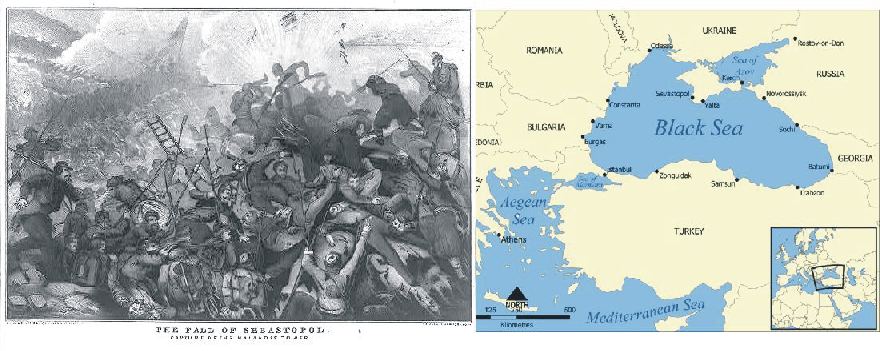
The fall of Sebastopol September 1855, after a year-long siege by the French and British fleets.
In
April 1854 allied troops landed in the Crimea and besieged the city of
Sebastopol, home of the Tsar's fleet. During the siege, in November 1854, a
major part of the French-English fleet was destroyed in the
Click here to jump back to the list of contents.
1876:
The Merchant Shipping Act and the Plimsoll Sensation
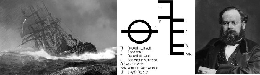
Ship in storm of the south coast of England around 1870 (left). The Plimsoll markings on ships; the long-awaited load line for different oceanographic conditions (centre). Samuel Plimsoll (right).
During the 19th century, British trade with the rest of the world was growing rapidly. The large number of ships being wrecked each year caused greater and greater concern. For example, in the year 1873-4, 411 ships sank around the British coast, with the loss of 506 lives. Between 1830 and 1900 about 70 percent of all sailing ships of the Tyne in England were lost a sea. During those same years one out of every five English mariners who embarked on a life at sea also died at sea (Jones 2006). Overloading and poor maintenance made some ships so dangerous that they became known as 'coffin ships', especially as gales and storms were frequent during the Little Ice Age.
By the 1870 Merchant Shipping Act in England sailors could be imprisoned for three months for breach of contract if they refused to board an unseaworthy ship once they had signed up for a voyage. Between 1870 and 1872, 1628 sailors were sent to jail in Great Britain for refusing to go to sea in ships they thought were unseaworthy.
In 1870, Samuel Plimsoll MP, who was a coal merchant, became interested in the subject. He began to write a book about the disastrous effects of overloading ships without respect to bad weather. When he began to investigate, Plimsoll found the problem was even worse than he had expected. He began to campaign in parliament with the aim of improving safety at sea. Many ordinary people became interested in his book and his campaign. In 1872, a Royal Commission on Un-seaworthy Ships was set up to look at evidence and recommend changes. Plimsoll was, however, defeated several times in parliament and ridiculed in public. Especially many ship owners were reluctant toward introducing regulations of ship loading.
Friday 10 February 1871 a storm blew up in the Channel and in the North Sea. Many ships went down because they were to heavy loaded to ride the waves, and many sailors lost their lives. There was a public outcry in Great Britain following this disaster. For Samuel Plimsoller (MP) this particular storm became the tipping point for public opinion.
On 12 August 1876, after years of negotiations in the English parliament a new Merchant Shipping Act was passed with the Lord's amendments (Jones 2006). The Art had 45 clauses. No 26 was ground-breaking: it made a load line on every ship compulsory. Thereby the storm of 10 February 1871 and the long work by Samuel Plimsoller established the famous symbol, of a circle, twelve inches in diameter, with a line through the middle, which popularly took Plimsoll's name.
The Merchant
Shipping Act of 1876 made load lines compulsory, but the position of the line in
the ship hull was not fixed by law until 1894. In 1906, foreign ships were also
required to carry a load line if they visited British ports. Since then, the
line has been known in the
Even in modern times, whenever controversies generating strong feelings arise, references are made and analogies drawn to the Plimsoll case.
Click here to jump back to the list of contents.
1879:
The Tay Rail Bridge
disaster in Scotland
A
deep depression with strong winds (Beaufort force 10-11) was passing across
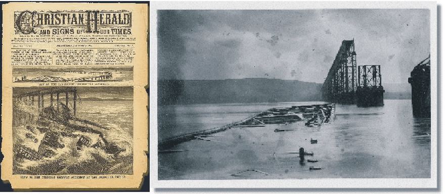
The Tai Rail Bridge disaster 28 December 1879, as documented by contemporary a contemporary newspaper. The old photograph to the right shows the central box-shaped section of the bridge lying on a sandbank in the river. The entire train, with the exception of the second-class carriage and the van, was contained within this section, explaining why nobody managed to escape drowning.
Today
there is still speculation as to the exact cause for the disaster, even though
the sheer force of the wind is seen as the fundamental cause (Burt
2004). One theory suggests that the bridge was not designed to withstand the
strong winds experienced in the evening of
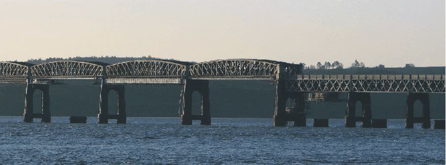
The new Tay Rail Bridge January 6th, 2008, looking SW. The old pier remains of the old bridge is seen below the modern bridge and provide a grim reminder of the 1879 disaster.
Click here to jump back to the list of contents.
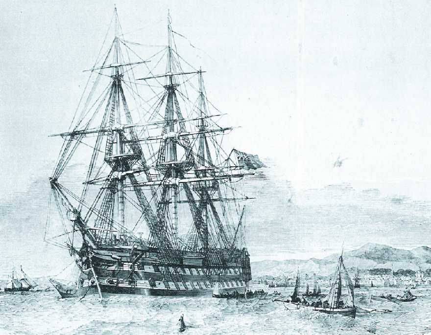
1879-1881:
USS Jeannette sails for the North Pole
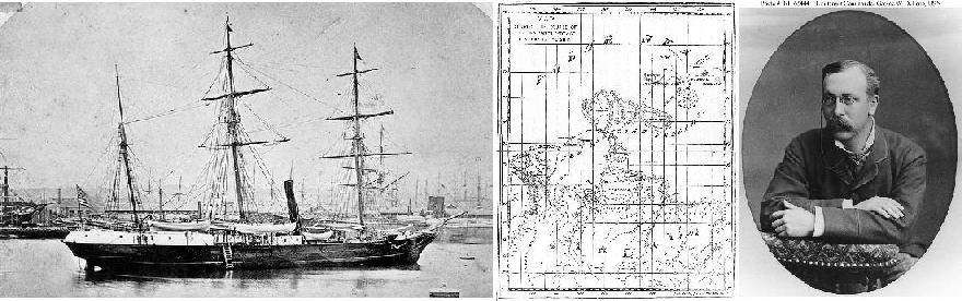
USS Jeannette (left).
Map showing the trek to the Siberian coast from the point
where USS Jeannette was crushed by ice (centre). Lieutenant
Commander George W. DeLong, USN
The
43 m long USS Jeannette was originally a gunboat (HMS Pandora) in the British
Royal Navy. In 1878 it was purchased by the owner of the New York Herald (James
Gordon Bennett, Jr.), and renamed Jeannette. Bennett was interested in the
The
Jeannette was modified and massively reinforced to allow her to navigate in the
Arctic pack ice. Lieutenant Commander George W. DeLong, USN, who had
considerable Arctic experience, was given the command. The crew consisted of 30
officers and men and 3 civilians. The ship contained the latest in scientific
equipment; and, in addition to reaching the Pole through
Bound
for the North Pole, Jeannette departed
On
The
two seperated parties began the long march inland over the swampy and half-frozen delta, hoping to find
settlements. One by one, however, members of DeLong's group died from starvation and exposure. Finally
DeLong sent his two strongest men ahead alone for help. They eventually managed
to find a settlement, but DeLong and the remaining men died before rescue arrived. The
other group under Melville was more lucky and relatively rapid found a native village on the other side of the
delta and were all rescued.
In
the summer of 1884 wreckage from the Jeannette was found on sea ice floes near
the southern end of
Click here to jump back to the list of contents.
1883:
The Krakatau volcanic eruption 
The explosive Krakatau eruption in Indonesia 27 May 1883 released huge amounts of ash into the atmosphere, giving rise to spectacular sunrise and sunset phenomena for a couple of years. Several painters have recorded this effect in their artwork.
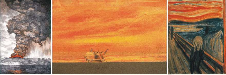
Painting of the Krakatau eruption 27 May 1883 (left). Oil painting 'Sunset' by Thames 23 Nobember 1883 (centre). The painting 'Skrik' (the Scream) 1893 by Edvard Munch (right). The dramatic skyline in this painting is thought to have been inspired by the global optical effects caused by the 1883 Krakatau eruption as seen over Oslofjord in the years thereafter.
Click here to jump back to the list of contents.