Snow cover
Open Climate4you homepage
Recent northern hemisphere snow cover
2024 2025
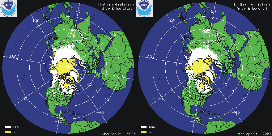
Northern hemisphere snow cover (white) and sea ice (yellow) 26 April 2024 (left) and 2025 (right). Map source: National Ice Center (NIC). Please use this link if you want to see the original figures or want to check for more recent updates than shown above.
Click here to jump back to the list of contents
2024 2025
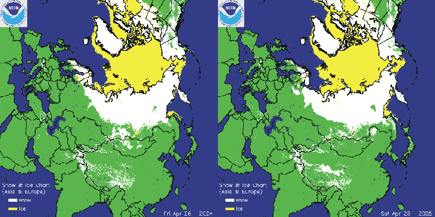
Europe-Asia snow cover (white) and sea ice (yellow) 26 April 2024 (left) and 2025 (right). Map source: National Ice Center (NIC). Please use this link if you want to see the original figures or want to check for more recent updates than shown above.
Click here to jump back to the list of contents
Recent Alaska-Canada snow cover
2024 2025
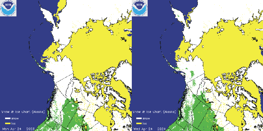
Alaska-Canada snow cover (white) and sea ice (yellow) 26 April 2024 (left) and 2025 (right). Map source: National Ice Center (NIC). Please use this link if you want to see the original figures or want to check for more recent updates than shown above.
Click here to jump back to the list of contents
2024 2025
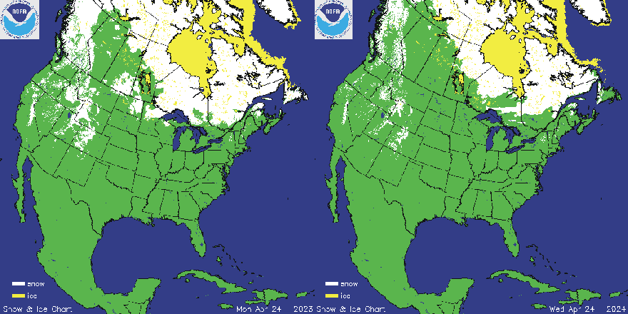
USA-Canada snow cover (white) and sea ice (yellow) 26 April 2024 (left) and 2025 (right). Map source: National Ice Center (NIC). Please use this link if you want to see the original figures or want to check for more recent updates than shown above.
Click here to jump back to the list of contents
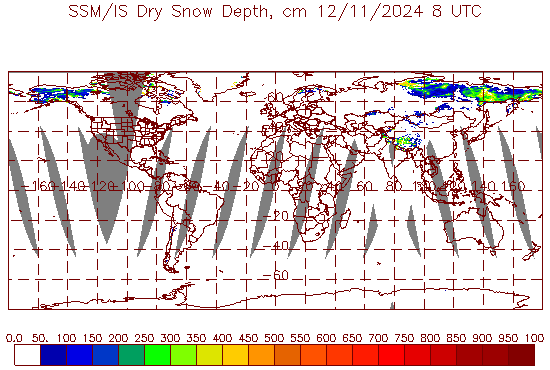
Recent Northern Hemisphere seasonal snow depth (cm) 11 December 2024, according to NOAA (SSM / IS Products). Please use this link if you want to see the original diagram or want to check for a more recent update than shown above.
Click here to jump back to the list of contents
Northern hemisphere weekly snow cover since 1972
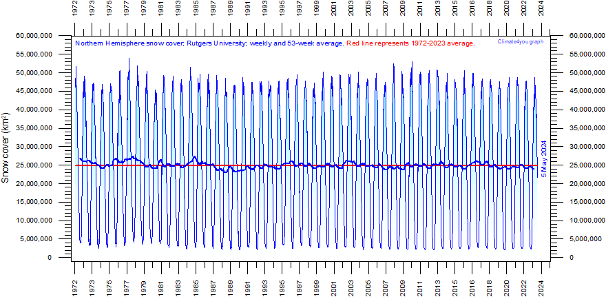
Northern hemisphere weekly snow cover since January 1972 according to Rutgers University Global Snow Laboratory. The thin blue line is the weekly data, and the thick blue line is the running 53 week average (approximately 1 year). The horizontal red line is the 1972-2024 average. Last week shown: week 18 in 2025. Last figure update 7 May 2025.
-
Please use this link to download the original data.
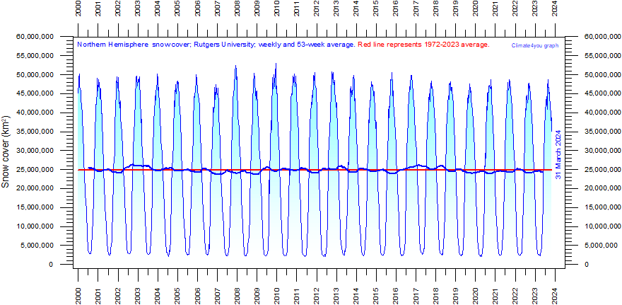
Northern hemisphere weekly snow cover since January 2000 according to Rutgers University Global Snow Laboratory. The thin blue line is the weekly data, and the thick blue line is the running 53 week average (approximately 1 year). The horizontal red line is the 1972-2024 average. Last week shown: week 18 in 2025. Last figure update 7 May 2025.
-
Please use this link to download the original data.
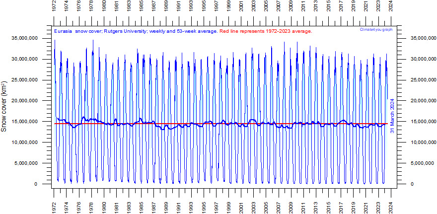
Eurasia weekly snow cover since January 1972 according to Rutgers University Global Snow Laboratory. The thin blue line is the weekly data, and the thick blue line is the running 53 week average (approximately 1 year). The horizontal red line is the 1972-2024 average. Last week shown: week 18 in 2025. Last figure update 7 May 2025.
-
Please use this link to download the original data.
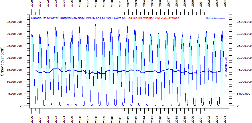
Eurasia weekly snow cover since January 2000 according to Rutgers University Global Snow Laboratory. The thin blue line is the weekly data, and the thick blue line is the running 53 week average (approximately 1 year). The horizontal red line is the 1972-2024 average. Last week shown: week 18 in 2025. Last figure update 7 May 2025.
Please use this link to download the original data.
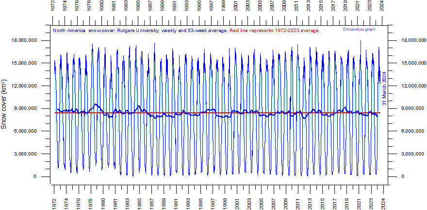
North America (Greenland excluded) weekly snow cover since January 1972 according to Rutgers University Global Snow Laboratory. The thin blue line is the weekly data, and the thick blue line is the running 53 week average (approximately 1 year). The horizontal red line is the 1972-2024 average. Last week shown: week 18 in 2025. Last figure update 7 May 2025.
-
Please use this link to download the original data.
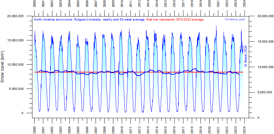
North America (Greenland excluded) weekly snow cover since January 2000 according to Rutgers University Global Snow Laboratory. The thin blue line is the weekly data, and the thick blue line is the running 53 week average (approximately 1 year). The horizontal red line is the 1972-2024 average. Last week shown: week 18 in 2025. Last figure update 7 May 2025.
-
Please use this link to download the original data.
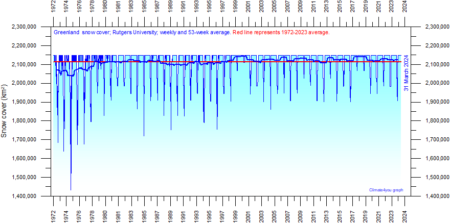
Greenland weekly snow cover since January 1972 according to Rutgers University Global Snow Laboratory. The thin blue line is the weekly data, and the thick blue line is the running 53 week average (approximately 1 year). The horizontal red line is the 1972-2024 average. Last week shown: week 18 in 2025. Last figure update 7 May 2025.
-
Please use this link to download the original data.
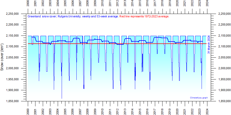
Greenland weekly snow cover since January 2000 according to Rutgers University Global Snow Laboratory. The thin line is the weekly data, and the thick line is the running 53 week average (approximately 1 year). As the whole of Greenland usually becomes snow covered during winter, the graph hits a ceiling during this period. Therefore, what is of main interest is the development of the summer minimum snow cover. The horizontal red line is the 1972-2024 average. Last week shown: week 18 in 2025. Last figure update 7 May 2025.
-
Please use this link to download the original data.
During the satellite-era of snow cover observations (from October 1966) the winter season snow cover in the northern hemisphere have been somewhat variable, but without a clear trend for any of the regions considered. For most regions there has been a relatively small decrease in the average area snow covered annually. However, based on the above observations, it would be difficult to characterize the overall reduction as very pronounced.
For Greenland the maximum extension of the snow cover happens when the island is totally snow covered, wherefore the Greenland graph becomes stable each winter on a value corresponding to the total land area. Of greater interest for Greenland then becomes the minimum snow covered area reached each summer. This minimum value display variations throughout the observational period since 1966, but the overall trend appears to be that of an increasing trend in the size of the area covered by snow at the end of the summer in Greenland.
Click here to jump back to the list of contents
Northern hemisphere seasonal snow cover since 1972
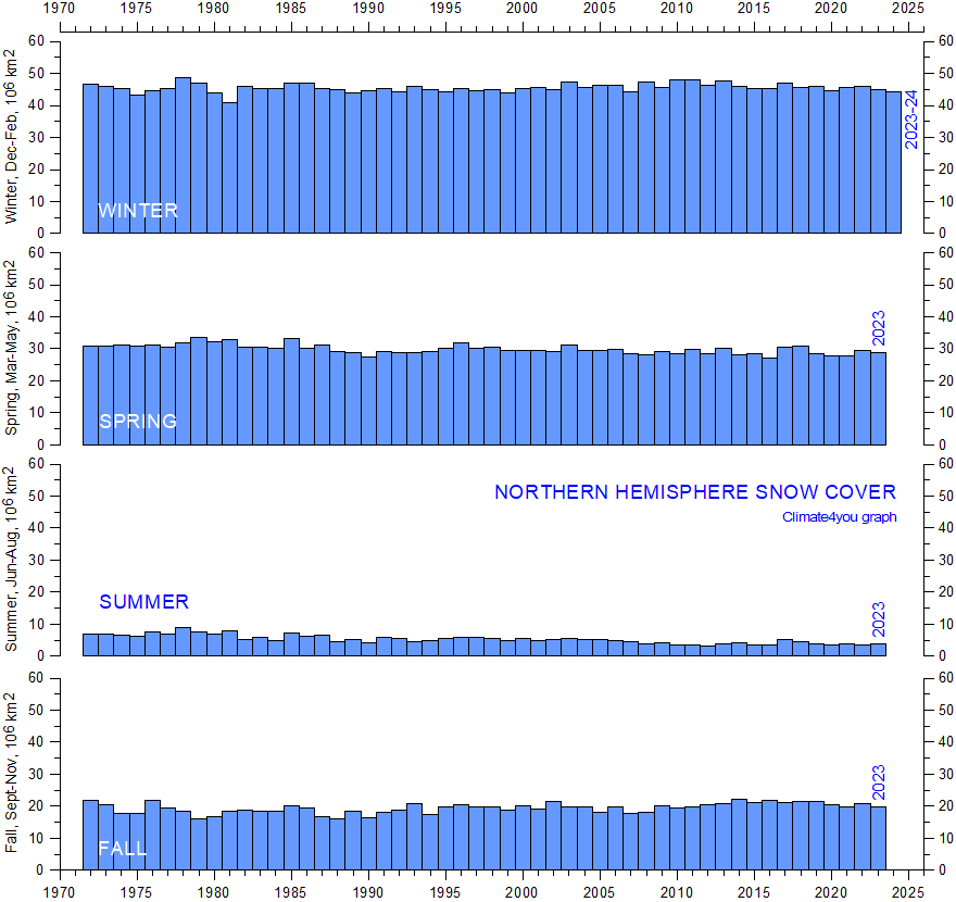
Northern Hemisphere seasonal snow cover since 1972 according to Rutgers University Global Snow Laboratory. Winter = Dec-Jan-Feb. Spring = Mar-Apr-May. Summer = Jun-Jul-Aug. Fall = Sep-Oct-Nov. Last figure update 11 March 2025.
-
Please use this link to download the original data.
Click here to jump back to the list of contents
Snow cover variations in southern Norway since 1896
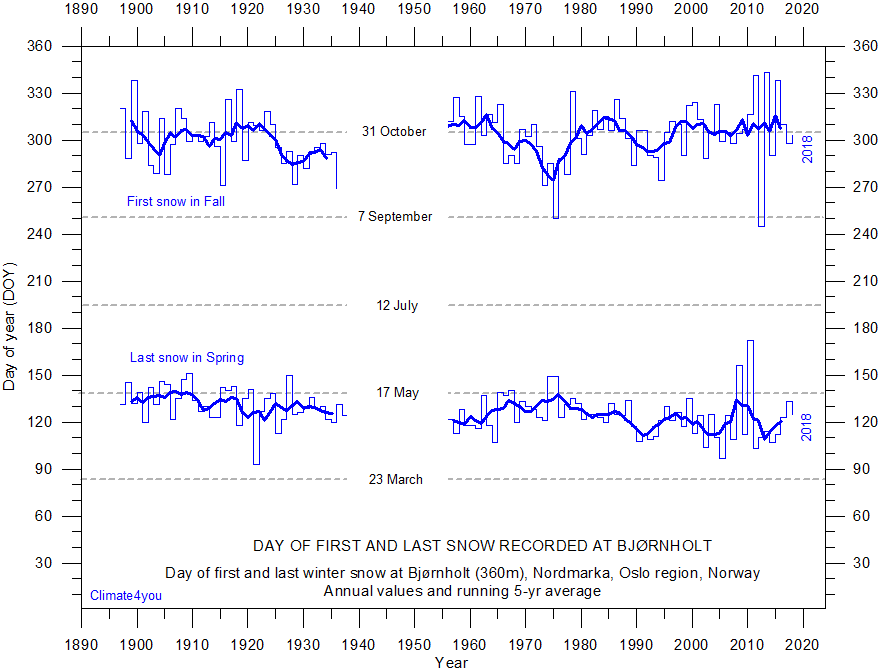
Timing of winters first and last snow at Bjørnholt (60.05N, 10.69E, 360 m asl.) near Oslo, southern Norway, since 1896. There are no data between July 1937 and August 1954. Click here to download the original data (you have to register, but the service is free). Last diagram update: 7 November 2018.
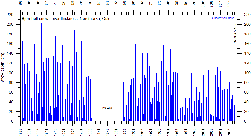
Daily snow cover thickness and -duration since 1896 at Bjørnholt (60.05N, 10.69E, 360 m asl.) near Oslo, southern Norway. There are no data between July 1937 and August 1954. Click here to download the original data (you have to register, but the service is free). Last day shown: 15 January 2019. Last diagram update: 17 January 2019.
The above data are interesting, as they illustrate snow cover conditions in southern Norway during the last period of the so-called Little Ice Age, which in Norway and adjoining regions ended early in the 20th century. Data are lacking 1937-1954, but between 1954 and 1965, the average winter snow cover thickness was relatively small, when compared to early part of the record. A somewhat thicker snow cover is characterising the period 1966-1988, more or less contemporaneous with a period characterised by relatively low winter temperatures. Since 1989, the average winter snow cover thickness at Bjørnholt has again been lower than previously, but comparable to the average thickness recorded for the years leading up to 1965.
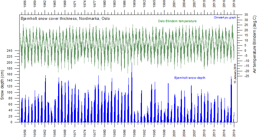
Daily snow cover thickness and -duration (blue) since 1954 at Bjørnholt (60.05oN, 10.69oE, 360 m asl.) near Oslo, southern Norway. In the upper part of the diagram the daily average air temperature (green) at Blindern (Oslo) is shown. Click here to download the original snow and temperature data (you have to register, but the service is free). Last day shown: 15 January 2019. Last diagram update: 17 January 2019.
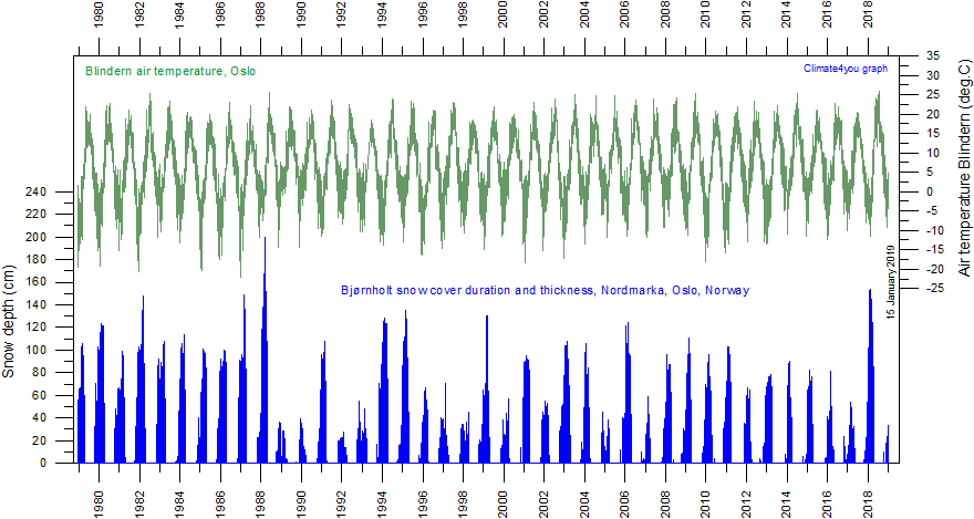
Daily snow cover thickness and -duration (blue) since 1979 at Bjørnholt (60.05oN, 10.69oE, 360 m asl.) near Oslo, southern Norway. In the upper part of the diagram the daily average air temperature (green) at Blindern (Oslo) is shown. Click here to download the original snow and temperature data (you have to register, but the service is free). Last day shown: 15 January 2019. Last diagram update: 17 January 2019.
The above diagram covers the time period since 1979 adopted for several global temperature graphs used on this webpage. The change from a relatively thick snow cover at Bjørnholt before 1989 is seen to be step-like, and not the result of a gradual development over time. Accordingly, great care should be exercised when attempting to illustrate the snow cover development by statistical methods. A simple approach using linear trends across such a step-like change may well be both meaningless and misleading. The years 1989-1993 following the 1988 record high snow cover thickness at Bjørnholt are characterised by a much shallower winter snow cover. The air temperature graph shows that these winters were relatively warm. From 1994, a somewhat thicker snow cover again becomes normal, but with significant inter-annual variations. It is difficult to see any clear trend as to snow cover thickness at Bjørnholt since 1989, provided one ignores the period 1989-1993 where the average snow cover thickness was very low, with the exception of the winter 1990-91.
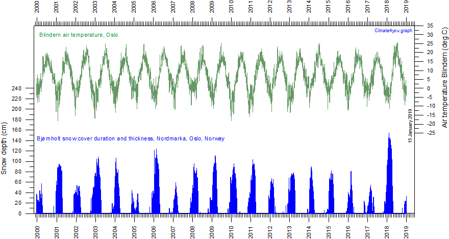
Daily snow cover thickness and -duration (blue) since 2000 at Bjørnholt (60.05oN, 10.69oE, 360 m asl.) near Oslo, southern Norway. In the upper part of the diagram the daily average air temperature (green) at Blindern (Oslo) is shown. Click here to download the original snow and temperature data (you have to register, but the service is free). Last day shown: 15 January 2019. Last diagram update: 17 January 2019.
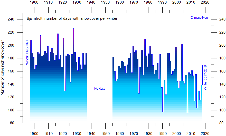
Number of days with snowcover since winter 1896-1897 at Bjørnholt (60.05N, 10.69E, 360 m asl.) near Oslo, southern Norway. There are no data between July 1937 and August 1954. Click here to download the original data (you have to register, but the service is free). Last winter shown: 2017-2018. Last diagram update: 28 May 2017.
Click here to jump back to the list of contents