Arctic
meteorology
Modern
meteorological conditions and climate in the Arctic
is to a high degree
regulated by the advection of warm North Atlantic
waters into the
Nordic
Seas,
the Norwegian- and the
Greenland Sea
. Maritime climate conditions therefore prevail over much of the Arctic Ocean, coastal Alaska,
Iceland,
northern
Norway
and adjoining parts of
Russia. In these areas, winters are cold and windy. Summers are cloudy and cool with
mean temperatures ranging from 4 to 8oC over land areas. Annual
precipitation is generally between 600 mm and 1300 mm (w.e.), with a cool season
maximum (largely snowfall) and about five to seven months of continuous snow
cover (e.g., Berry et al. 1993; Barry
and
Chorley 1998). Shallow permafrost (0-250 m) characterise these regions.
Forests are usually absent or found only close to sea level in sheltered
positions due to low summer temperatures and/or windy conditions (Humlum
and Christiansen 1998).
Arctic
interior continental climates have more severe winters and precipitation is
usually small. The coldest part of the Northern Hemisphere is located in
northeast
Siberia
near the city Verkhoyansk (Lydolph
1977), where present mean winter (DJF) air temperature is –43oC.
Although frost may occur in any month, long summer days usually provide three
months with mean temperatures above 10oC, and at some sites in the
continental interiors summer temperatures may exceed 30oC. In such
regions, forests extend 200-1000 km north of the southern limit of permafrost
and, consequently, permafrost extends far beyond the traditional warm limit of
periglacial environments (the tree line). Permafrost is widespread and typically
reaches 300-600 m thickness.
In
winter, arctic weather is dominated by the frequent occurrence of inversions
where warm air overlies colder air near the terrain surface, decoupling surface
winds from stronger upper layer winds. For this reason, surface wind speeds tend
to be lower in winter than one might expect and cold (and dense) air tend to
accumulate in topographic lows. In summer, inversions are less frequent and
weaker, and the movement of low-pressure systems (cyclones) periodically
dominate Arctic weather, even in central
Siberia
and in the
Arctic
Basin
.
The
Arctic
is characterized by "semipermanent"
patterns of high and low pressure (Serreze et al.
1993; Serreze et al. 1995; Serreze
and Barry 1998). These patterns are semipermanent because they appear in
charts of long-term average surface pressure. They can be considered to largely
represent the statistical signature of where transitory high and low pressure
systems that appear on synoptic charts tend to be most common. This pattern is
relatively weakly developed in summer, but stronger in winter.
The
Icelandic Low is such a semipermanent low-pressure centre located between
Iceland
and southern
Greenland
. It is most intense during winter, while
in summer it weakens and frequently splits into two centres, one near
Davis Strait
and the other between
Iceland
and
SE Greenland. Travelling cyclones formed in the
subpolar latitudes in the
North Atlantic
usually slow down and reach maximum
intensity when they pass the area of the Icelandic Low. The Aleutian Low is
another semipermanent low-pressure centre, located near the
Aleutian Islands
in the
Northern Pacific Ocean
. Also most intense in winter, the
Aleutian Low is characterized by many strong cyclones. Like the Icelandic Low,
travelling cyclones tend to slow down and intensify while passing the Aleutian
Low. Areas of significant winter cyclonic activity (storm tracks) are found in
the North Pacific and
North Atlantic. These channel heat, momentum and
moisture into the Arctic, and significantly influences upon the
high latitude climate.
Winter
cyclones in the Eurasian Arctic occur most frequently in the Barents and Kara
Seas
region, bringing in pulses of warm air,
causing rapid warming and snow melt even in the middle of winter. Over the North
Atlantic Arctic, the highest frequency of cyclones occurs east of
Greenland
after having passed through the
Icelandic Low. Cyclones are also common in
Baffin Bay
between
Greenland
and Canadian Arctic.
The
summer distribution of air pressure and frequency of cyclones is different from
that of winter. With more uniform temperatures over the northern parts of the
Atlantic
and Pacific oceans, summer cyclones tend
to be weaker than their winter counterparts and the semipermanent Icelandic and
Aleutian Lows weaken. In July and August, few strong cyclones move to the
Arctic Ocean
from the northern
Atlantic
, while several weak cyclones move
towards the pole from the midlatitudes of
Siberia
and Canada
.
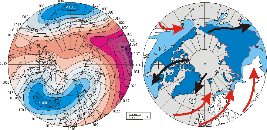
Left
diagram shows winter (DJF) sea-level pressure (SLP) averaged over the period
1900-2001. Isobars are spaced every 3 hPa with red colors used for SLP values
greater or equal than 1013 hPa and blue colors used for lower values. Numbers at
circumference indicate SLP values in hPa. Right diagram shows the modern
distribution of permafrost in the Northern Hemisphere. Continuous permafrost is
shown by dark blue color. Discontinuous and sporadic permafrost is shown by
light blue color. Red and black arrows show main surface air flow (warm and
cold, respectively) as generated by the 20th century pattern of SLP.
The overall windsystems set up by the average winter sea-level pressure appears
to represent one of several controls on the present distribution of permafrost
in the northern hemisphere.
The
Siberian High is an intense, cold anticyclone that forms over eastern
Siberia
in winter (see figure above). Prevailing
from late November to early March, it is associated with frequent cold air
outbreaks over East Asia. Strong cooling in this region results
in the lowest air temperatures in the Northern Hemisphere. A persistent
anticyclone or high-pressure ridge called the Arctic High, also known as the
Beaufort High, is located over the
Beaufort Sea
and the Canadian Archipelago in winter
and spring. The North American High is a relatively weak area of high pressure
that covers most of
North America
during winter. This pressure system
tends to be centred over the Yukon, but is not as well defined as its
continental counterpart, the Siberian High. In the winter and spring,
anticyclones in the Russian Arctic move mainly from the circumpolar regions
through the eastern parts of the Barents and Kara seas. Some also move into the
Barents Sea
from the northern coast of
Greenland
. The sea level pressure distribution in
summer is dominated by subtropical highs in the eastern Pacific and
Atlantic
oceans, with relatively weak pressure
gradients in polar and subpolar regions. Arctic anticyclones are less common and
generally weaker in summer.
Unsolved climatological and
meteorological issues in the Polar Regions
The
meteorology of the
Polar Regions
is still poorly understood
compared to other regions, and both better observational data and a more
thorough analysis of existing data sets are needed to remedy this situation. In
particular, the potential control exercised by local temperature inversions on
registered Arctic surface air temperatures during the winter season should be
investigated for individual meteorological stations. Many of these are located
in or near settlements, which tend to be localised in topographic lows, in
valleys, along rivers, etc. For such stations the frequent occurrence of winter
temperature inversions during periods of calm causes them to be located in a
shallow layer of very cold air, thereby recording extraordinary low temperatures
not necessarily representative for the region as such. If the average number of
calm conditions with temperature inversions during winter is reduced in periods
with increased cyclonic activity, this will be recorded as a temperature
increase, and vice versa. In summer, inversions are less frequent and weaker,
and this potential source of error therefore smaller. New meteorological
stations located at high altitudes will help solve this methodological problem (Christiansen
and Mortensen, 2002).
The
urban heat-island effect in the Arctic
deserves
separate scrutiny to improve the quality of existing meteorological records. At
the village
of
Barrow, Alaska, Hinkel
et al. (2003) recently demonstrated the existence of a strong urban heat
island during winter. During winter the urban area averaged 2.2 °C warmer than
the hinterland. The strength of the local heat effect increased as the wind
velocity decreased, reaching an average value of 3.2°C under calm (<2 m/s)
conditions and maximum single-day magnitude of no less than 6°C. Barrow has
grown from a size of about 300 residents in 1900 to more than 4600 in 2000.
A
central issue in Polar Region climate dynamics is to understand how climates in
the Northern and Southern hemispheres are coupled. The strongest of the rapid
temperature changes observed in
Greenland
(so-called
Dansgaard-Oeschger events) during the last glaciation have an analogue in the
temperature record from
Antarctica
(Blunier
et al. 1998). A comparison of the global atmospheric concentration of
methane as recorded in ice cores from Antarctica
and
Greenland
permits
a determination of the phase relationship (in leads or lags) of these
temperature variations.
Greenland
warming
events around 36 and 45 ka BP before present are lagging behind their Antarctic
counterpart by more than 1 ka. On average, Antarctic climate change leads that
of
Greenland
by
1±2.5 ka over the period 47±23 ka BP (Blunier et
al. 1998). Also on shorter time scales, there appears to be an out-of-phase
between climatic development in the
Arctic
and
the Antarctic, such as demonstrated by the late 20th century cooling
in the Antarctic and the contemporary warming in the
Arctic
(Ingólfsson
et al. 2003).
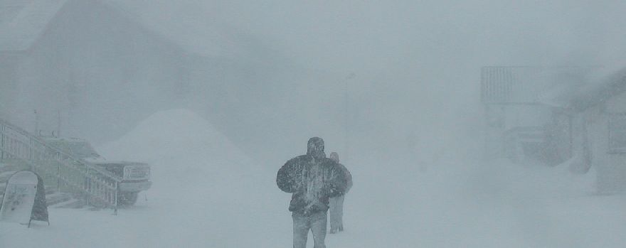
Blizzard
in Longyearbyen, Svalbard, 8 April 2003.
Another pressing
meteorological issue is the distribution of precipitation
in the Arctic, itself representing a
complex problem, subject of long-standing debate and compounded by the paucity
of meteorological stations. While air temperatures today are registered at
Arctic meteorological stations with relative small technical difficulties,
except for sites with icing conditions, precipitation is considerably more
complicated to measure correctly, especially when in solid form. Many Arctic
meteorological stations have simply avoided measuring precipitation due to
severe problems by doing so. In addition, little is known about the local and
regional effect of altitude and topography on precipitation. Also the local and
regional importance of redistribution of snow by wind is usually virtually
unknown (Humlum 1987; Humlum
2002; Humlum et al. 2003; Nordli
and Kohler 2003). Finally, much of the information that does exist on
precipitation within the Arctic tends to be widely scattered in the scientific
literature and is often viewed only in the context of a particular local
problem, with little emphasis on the regional amount of precipitation (Humlum
2002). In addition, high-latitude trends in measured precipitation are
influenced by gauge undercatch. At a meteorological station exposed to warming,
the fraction of annual precipitation falling as snow diminishes, and vice versa.
As the gauge undercatch is substantially larger for solid than for liquid
precipitation, this implies that a fraction of any observed positive
precipitation trend is fictitious, caused by reduced undercatch in the
precipitation gauges (Førland and Hanssen-Bauer
2000). For these reasons, we have shunned from discussing precipitation in
this contribution.
The
general problem of reliable records on Arctic
precipitation, however, remains, and also has implications for knowledge on
duration and thickness of the snow cover, significant for the ground thermal
regime (Ballantyne 1978; Humlum
et al. 2003). Snow plays a key role in protecting plants and animals from
cold dry winter conditions. It is also important for the seasonal water cycle.
Variations in the snow cover may therefore have profound impact on biological
activity and geomorphic activity in the Arctic. In addition, the
snow cover also has a direct effect on the distribution of permafrost on both
local and regional scale (Humlum et al. 2003).
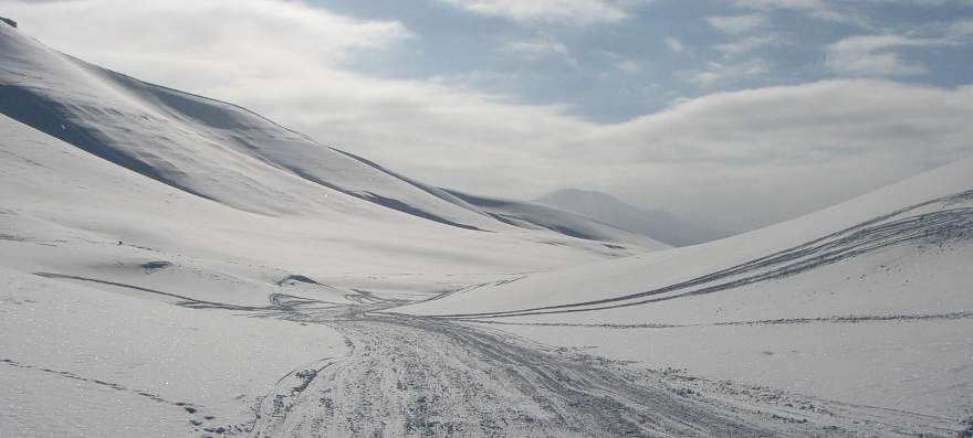
In arid parts of the Arctic land regions the average winter snow cover is thin
and the ground surface cools rapidly during the winter. Conversely, in more
maritime areas the snow cover usually is thicker and reduces heat loss from the
ground surface during winter. Interannual variations in the establishment of the
snow cover are also important. A dry and cold autumn enables enhanced cooling of
the active layer and topmost permafrost, while high snowfall during late winter
and late onset of snow melt protect the ground against thawing in early summer.
The combination of these two meteorological phenomena is likely to be beneficial
for conservation and growth of permafrost. Variations in the timing and duration
of seasonal snow cover presumably also have an influence on active layer
thickness, but the effect is still not known in detail (Humlum
et al. 2003).
A specific problem adheres to the lack of knowledge on mountain climate
in general. Despite the fact that high-relief areas (mountains) account for
about 20 per cent of the earth’s land surface, the meteorology of most
mountains is still little known. Meteorological stations are few and tend to be
located at conveniently accessible sites, often in valleys or along coasts,
rather than at points selected to obtain representative data. Precipitation
distribution in mountain areas has been a subject of debate and controversy
since the publication on orographic rainfall by Bonacina
(1945). The problem is compounded by the above-mentioned paucity of
high-altitude meteorological stations and the additional technical difficulties
of determining snowfall contributions to total precipitation, especially at
windy sites. As recognized early by Salter (1918)
from analysis of British data, the effect of altitude on the vertical
distribution of precipitation in mountain areas is highly variable between even
nearby geographical locations.
This poor understanding of the dynamics and characteristics of mountain
climate is particularly pronounced for the Arctic
(Humlum
2002). This is unfortunate; partly because of existing predictions of an
amplified response of northern high-latitude regions to various climatic forcing
mechanisms (see above), partly because most geomorphic activity is not
controlled by temperature only, but very much also by precipitation and wind,
e.g. frost weathering, gelifluction, active layer processes (e.g., Etzelmüller
and Sollid 1991) and the dynamics of glaciers (e.g., Dowdeswell
et al. 1997). Also any kind of biological activity is likely to be
influenced by the amount of precipitation.