Year 0-1000
300
BC -400 AD: Glacier retreat in the Alps 
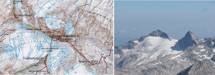
Großer Sonnblick in southern Austria. Map (left) and photo seen from the south-east (right). The peak seen to the left in the photo is Goldzechkopf, while Großer Sonnblick is to the right.
Many glaciers in the Alps apparently retreated from about 300 BC to about 400 AD (Delibrias et al. 1975). At that time they probably were comparable in size or even less extensive as today, as is indicated by Roman gold mines established high up in the Alps in the Sonnblick area (Austria).
Traffic
over Alpine passes at that time continued even in winter time, and actual
reports of winters in central and northwestern Europe that are recorded from
those times indicate only few that were notable for snows (Lamb
1977).
Gold and Silver have been mined in this region for several thousands of years, and the the Greek geographer Strabo gives the first record for gold mining in the region. Most probably mining activities started in Pre-Roman time like in many other places in the Salzburg region (copper in Muehlbach and salt at Hallein/Duerrnberg).
At Hocharn the mines at the Goldzeche and at Grieswies-Schwarzkogel were most important. The underground workings reached heights of more than 3000m and are considered to be the highest gold mines in Europe.
It
appears that after the collapse
of the Roman Empire in AD 476 some of the mines were blocked by advancing
glaciers, and therefore given up. The entrance to some of these mines are
probably still covered by glacier ice while others have only recently come to
light as the glacier retreated in the 20th century (Lamb
1977, 1995).
However, several of the mine entrances apparently again became free of ice during the Medieval warm period, and in late medieval times the Salzburg region became the world´s largest producer of gold. In the 19th century advancing glaciers blocking the entrance to the mines (many glaciers in the eastern Alps reached their Little Ice Age maximum around 1860) and falling gold price and caused the closure of many gold mines in this region of Austria. Mining finally ceased at the end of World War II.
Nowadays many topographic names remind of the historic gold mining (Hoher Goldberg, Goldzeche, Goldzechkopf, Goldlacklschneid, Pochkar, Silberpfennig, Erzwies, Huettwinkel). Gold can still be found at Hocharn and Großer Sonnblick. The Großer Sonnblick reaches a height of 3,030 m and is the easternmost peak of the Alps that exceeds an altitude of 3,000 metres.
There
are still unmined economic ore bodies beneath both Hocharn and Sonnblick. But as
the impact of gold mining on nature and tourism would be large the gold will
presumably remain in these mountains.
Click here to jump back to the list of contents.
9
AD: Battle of the Teutoburg Forest
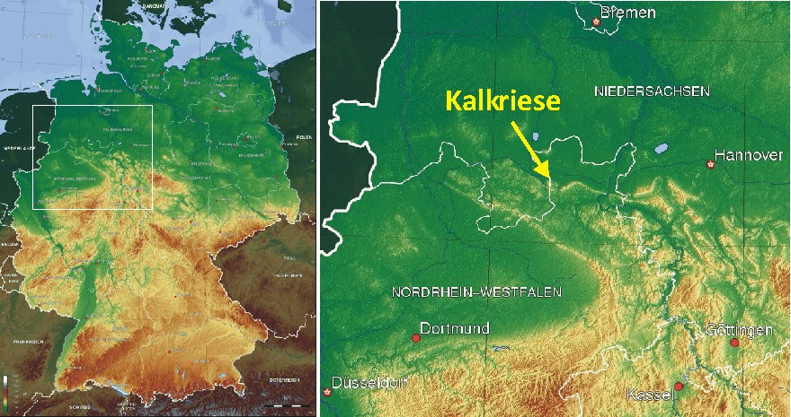
Topography
of Germany (left) with insert showing location of map section to the right.
Detailed map showing the location of the Battle at Teutoburg
Forest (right).
The
name of the Teutoburg
Forest (Teutoburger Wald) in northwestern Germany is connected to one of the
most famous battles from ancient history, the clades
Variana, the defeat of the Roman general Varus. In September 9 AD, a
coalition of Germanic tribes, led by a nobleman named Arminius, defeated a bir
Roman army consisting of three legions and other units, and forced their
commander Publius
Quintilius Varus to commit suicide.
The
result of the battle in Teutoburg Forest was that Germania remained independent
and was never included in the Roman Empire. Presumably the Roman defeat was
indeed one of the most decisive and influential battles in world history.
Weather played no small role in the outcome of this battle.
In
the last decade of the second century BC, the expanding Romans first encountered
Germanic tribes. The Cimbri
and Teutones
were considered dangerous enemies, but ultimately defeated by the Roman
commander Marius in two battles in BC 102 and 101. For two generations, all was
then quiet on the northern front, but in BC 58, when Julius
Caesar was waging war in eastern Gaul,
he got involved in a conflict with the Germanic leader Ariovistus.
At Colmar,
Caesar defeated his enemy, and Caesar subsequently bridged the Rhine and invaded
the country east of the river, which he called Germania.
Following
his successful campaign, Caesar declared the river Rhine as a natural boundary
between the Gallic barbarians ("Celts") and the Germanic tribes, which
in his official opinion were even more barbarous. In reality, Caesar needed a
well-defined theatre of operations and the Rhine was, from a military point of
view, a fine frontier. But from a cultural or ethnic point of view, it was not a
natural frontier at all. The Celtic
culture also existed on the east bank of the Rhine, and people speaking a
Germanic language had already settled on the west bank.
In
BC 39-38, Marcus
Vipsanius Agrippa was governor of Gaul, and fought a war on the east bank of
the Rhine on behalf of the Ubians
against the Suebians,
a Germanic tribe that was notorious for its aggressiveness. After this campaign,
Agrippa resettled the Ubians on the west bank of the Rhine, and founded Cologne.
The Rhine was now changing into being a frontier between an increasingly Roman
Gaul and an increasingly Germanic Germania.
During
this dynamic age, the tribes of the east bank sometimes raided the Roman empire
west of the Rhine. This happened in the winter of BC 17-16, where the governor
of Gallia
Belgica, Marcus
Lollius, was defeated by the Sugambri.
At this occasion the Fifth legion Alaudae lost its eagle standard: the ultimate
disgrace to a Roman army unit. The emperor Augustus
then understood that the Rhine frontier was still highly unstable and therefore
sent his adoptive son Drusus to the north, to pacify the region and create a
more stable frontier.
In
the years BC 16-13, the Romans reorganized the strip of land along the Rhine.
The region now became a military zone, where the army of Germania
Inferior defended the Roman Empire against invaders from Germania. A second
army group was called the army of Germania
Superior was stationed further south along the Middle Rhine. In the summer
of BC 11, Drusus managed to reach the river Elbe with his army. However, on his
way back home, he fell from his horse and died. The Roman conqueror of Germania
was only 29 years old.
Drusus
was succeeded by his brother Tiberius, a capable general who
held the opinion that Germania
was too cold and poor to ever represent a valuable part of the Roman Empire.
On the other hand, the armies could not be recalled immediately after the death
of Drusus, as this would look as if the Romans had been defeated. In the years
BC 9 and 8, Tiberius therefore attacked the Sugambri
and deported thousands of
them to the west bank of the Rhine.
After
this operation all now seemed quiet for a while along the upper reaches of the Rhine, and
in AD 4, Augustus ordered Tiberius to advance northeast again, to finish
the conquest of Germania. The whole of Germania was to become a normal,
tax-paying province, cold climate or not. The army of Germania Inferior
therefore was ordered to march from the Rhine to the sources of the river Lippe,
where a camp was built at Anreppen. Next year, the legions had a rendez-vous
with the Roman navy at the mouth of the Elbe, and Tiberius marched with his army
along the Elbe, which was to become the new northeastern frontier of the Roman
Empire.
Meanwhile, the army of Germania Inferior was commanded by Publius Quinctilius Varus, one of the most important senators of his age and a personal friend of Augustus. Varus was ordered to make a normal province of the country between the Lower Rhine and Lower Elbe, and indeed had some initial success in doing this. Then, everything suddenly went wrong, probably because Varus decided to impose tribute in the new Roman Province.
The
taxes imposed by Varus provoked resistance among a population that had at first
been willing to accept Roman rule, but was not prepared to pay this amount of
tribute. Presumably Varus did not take the gathering storm seriously, and as
usual sent smaller groups of Roman troops to various places in Germania, which
asked for them for the alleged purpose of guarding various positions, arresting
robbers, or escorting provision trains. Thereby
Varus did not keep his legions together, as would have been the proper procedure
in a hostile country.
Next
there came an uprising, first on the part of those who lived at large distances
away from the Roman headquarter, deliberately so arranged, in order that Varus
should march against them and so be more easily overpowered while proceeding
through what was supposed to be friendly country. Varus, on hearing the first
news about the revolt of a far-away tribe, sensibly decided to regroup his army
before taking any action.
All
sources agree that the Germanic leader of the uprising was Arminius, a member of
the Cheruscan tribe and until then a loyal supporter of Rome. The rebels (or
freedom fighters) must have made their
preparation during the late summer of 9 AD. However, not all Germanic leaders
agreed with Arminius' policy, and his plan was apparently betrayed to Varus.
What happened next is not entirely clear. Presumably Varus refused to listen,
and instead rebuked the person(s) that could have saved him.
The battle in Teutoburg Forest took place in the year 9 AD, most likely in September. The battles final stage took part at the northern foot of the Kalkriese hill, a site remarkably well-suited for an ambush. Although only 157 meters high, the Kalkriese is difficult to pass on its northern slope, because a traveller then has to cross many deep brooks and rivulets, and in the level terrain north of the Kalkriese extends a difficult wetland for large distances. However, in between this great bog and the hill exists a more accessible zone up to several hundred meters wide, consisting of stable, Quaternary sandy deposits. The most accessible part of this corridor has a width of only 220 meters. It therefore comes as no big surprise that much later, in the 19th century, German engineers choose this natural east-west corridor along the northern slope of Kalkriese for the construction of both the main road B218 and the Mittelland Canal further to the north.
In September 9 AD, Varus' forces included three legions (Legio XVII, Legio XVIII, and Legio XIX), six cohorts of auxiliary troops (non-citizens or allied troops) and three squadrons of cavalry. The Roman forces were not marching in combat formation, and were interspersed with large numbers of camp-followers.
As
they entered the forest shortly northeast of the modern town Osnabrück, they
found the forest track narrow and muddy, and at the same time a violent
rainstorm began. Apparently Varus neglected to send out advance reconnaissance
parties, but instead advanced with all his forces along the narrow track in one
long formation.
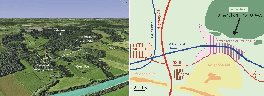
Overview
illustration of the Kalkriese Battlefield from Mike
Anderson’s Ancient History Blog (left). The Mittelland Canal is seen in
the foreground (direction of view towards SW). Overview
map showing the main features of the battlefield (right).
On this narrow track the Roman line soldiers rapidly became stretched out perilously long; estimates are somewhere between 15 and 20 km in total. The Roman forces were then suddenly attacked by Arminius's Germanic warriors armed with light swords, large lances and narrow-bladed short spears. The Germanic warriors quickly managed to surround the entire Roman army and rained down javelins on the intruders from the surrounding forest.
The German leader, Arminius, had grown up in Rome as a citizen and became a Roman soldier, understood Roman tactics very well and could thus direct his troops to counter them effectively, using locally superior numbers against the dispersed Roman legions. Indeed, the German warriors presumably used a very efficient tactic of isolating individual, manageable parts of the extended Roman column, to defeat them one by one. 1930 years later similar efficient ‘motti’ tactics were successfully employed by the Finnish army against the much bigger Red Army during the Finnish-USSR winter war 1939-40, again assisted by the prevailing weather.
The Roman main force however managed to set up a fortified night camp near Engter, and the next morning the remaining Roman soldiers managed to break out into the open country north of the Wiehen Hills, near the modern town of Ostercappeln. The break-out cost heavy losses, as did a further attempt to escape by marching through another forested area, with the torrential rains continuing.
According
to Cassius
Dio, Roman History (Historia Romana, in 80 books):
They
were still advancing when the fourth day dawned, and again a heavy downpour and
violent wind assailed them, preventing them from going forward and even from
standing securely, and moreover depriving them of the use of their weapons. For
they could not handle their bows or their javelins with any success, nor, for
that matter, their shields, which were thoroughly soaked. Their opponents, on
the other hand, being for the most part lightly equipped, and able to approach
and retire freely, suffered less from the storm.
The
continuing rain prevented the Roman forces from using their otherwise efficient
bows, because their sinew
strings become slack when wet. This rendered the Roman soldiers virtually defenceless
as their shields also became waterlogged and soft.
The
Romans then undertook a night march to escape, but marched into another trap
that Arminius had set, at the foot of Kalkriese Hill north of Osnabrück. There,
the sandy, open strip on which the Romans could march easily was constricted by
the hill to the south, so that there was a gap of only about 2-300 m between the
woods and swampland with high vegetation at the edge of the Great Bog to the
north. The Roman soldiers probably expected nothing at this stage, but were
suddenly attacked on their left flank by part of the Germanic forces hiding in
the swamp. Moreover, the Roman forces found the road ahead blocked by a
fortified trench, and, towards the forest, an earthen wall had been built along
the roadside, permitting the Germanic tribesmen to attack the Romans from cover.
The Roman forces was surrounded on three sides.
The Romans made a desperate attempt to storm the wall to break one part of the Germanic pincer, but failed. The highest-ranking officer next to Varus, Legatus Numonius Vala, abandoned the troops by riding off with the cavalry; however, he too was overtaken by the Germanic cavalry and killed. The Germanic warriors then stormed the field and slaughtered the now disintegrating Roman forces.
Varus
did what the Romans considered the honorable thing: he committed suicide. One
commander, Praefectus Ceionius, shamefully surrendered and later took his own
life, while his colleague Praefectus Eggius heroically died leading his doomed
troops to the bitter end.
Archeological
excavations in the area north of Kalkriese have shown that the staff of at least
one legion was present, and the presence of cavalry and auxiliary infantry is
also attested. There were also noncombatants and perhaps women at Kalkriese
mountain battlefield. In total, around 15,000–20,000 Roman soldiers must have
died; not only Varus, but also many of his officers are said to have taken their
own lives by falling on their swords in the approved manner.
Other
Roman soldiers from Germania had already reached the Rhine, and the news that
something terrible had happened spread upstream along the river. Even in Rome,
the populace was afraid, and the emperor Augustus ordered that watch be kept by
night throughout the city.
According
to Suetonius,
Augustus, 23.4:
He
(Augustus) was so greatly affected that for several months in succession he cut
neither his beard nor his hair, and sometimes he could dash his head against a
door, crying "Quintilius Varus, give me back my legions!"
The
battle in the Teutoburg Forest had a profound effect on 19th century German
nationalism; the Germans, at that time still divided into many individual German
states, identified with the Germanic tribes as shared ancestors of one
"German people" and came to associate the imperialistic Napoleonic
French and Austro-Hungarian forces with the invading Romans who were destined
for defeat. This was part of the background on which Bismarck,
the
German statesman, could unify numerous German states into a powerful German
Empire under Prussian leadership, and thereby create a "balance of power"
that preserved peace in Europe from 1871 until 1914.
Click here to jump back to the list of contents.
23-79
AD: Gaius Plinius Secundus and Naturalis Historia
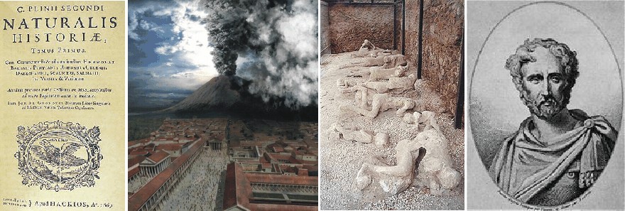
Naturalis Historia, 1669 edition, title page (left picture). The title at the top reads: "Volume I of the Natural History of Gaius Plinius Secundus. Mount Vesuvius during the 79 AD eruption (centre left). Plaster casts of the casualties of the pumice-fall, whose remains vanished leaving cavities in the pumice (centre right). Pliny the Elder (to the right): an imaginative 19th century portrait. No contemporary picture shoving Gaius Plinius Secundus has survived.
Gaius
Plinius Secundus (23 AD – August 25, 79 AD) is also known as Pliny the
Elder. He was a Roman author, naturalist, and natural philosopher, as well as
naval and army commander of the early Roman Empire, and personal friend of the
emperor Vespasian. Spending most of his spare time studying, writing or
investigating natural and geographic phenomena in the field, he wrote an
encyclopedic work, Naturalis
Historia, which became a model for all such works written subsequently, and
contributed to the survival in Europe of knowledge collected by Aristotle and
his students.
Gaius
Plinius was highly interested in agriculture, which he considered being the
single most important human type of activity. Agriculture depended on correct
planning of seasonal activities, and Gaius Plinius therefore collected much of
what was believed to be known about weather. Much of this knowledge on weather
phenomena is collected in volume two of his Naturalis
Historia, which consisted of no less than 37 volumes in total.
Below
is reproduced (in extract) the English
translation of some examples of Gaius Plinius writings on meteorological
phenomena, all taken from volume two of Naturalis Historia. The Latin version of
volume two can be found here.
Chap. XLII.
I
CANNOT
denie, but without these causes there arise raines and winds: for that certaine
it is, how there is sent forth from the earth a mist sometimes moist,
otherwhiles smokie, by reason of hote vapours and exhalations. Also, that clouds
are engendred by vapours which are gone up on high, or els of the aire gathered
into a waterie liquor: that they bee thicke, grosse, and of a bodily
consistence, wee guesse and collect by no doubtfull argument, considering that
they overshaddow the Sunne, which otherwise may be seene through the water, as
they know well, that dive to any depth whatsoever.
Chap. XLVII.
MEN in old time observed foure Winds only, according
to so many quarters of the world (and therefore Homer nameth no more:) a
blockish reason this was, as soone after it was judged. The Age ensuing, added
eight more; and they were on the other side in their conceit too subtile and
concise. The Moderne sailers of late daies, found out a meane betweene both: and
they put unto that short number of the first, foure winds and no more, which
they tooke out of the later. Therefore every quarter of the heaven hath two
winds apeece...
…The coldest winds of all other, be those which we
said to blow from the North pole, and together with them their neighbour, Corus.
These winds doe both allay and still all others, and also scatter and drive away
clouds. Moist winds are Africus, and especially the South wind of Italie, called
Auster…
…The North wind also bringeth in haile, so doth
Corus. The South wind is exceeding hote and troublous withall. Vulturnus and
Favonius bee warme. They also bee drier than the East: and generally all winds
from the North and West, are drier than from the South and East. Of all winds
the Northerne is most healthfull: the Southerne wind is noisome, and the rather
when it is drie; haply, because that when it is moist, it is the colder. During
the time that it bloweth, living creatures are thought to bee lesse hungrie. …
Chap. LX.
HAILE is engendred of Raine congealed into an Ice:
and Snow of the same humour growne togither, but not so hard. As for Frost, it
is made of dewe frozen. In winter Snowes fall, and not Haile. It haileth oftner
in the day time than in the night, yet haile sooner melteth by farre than snow.
Mists be not seene neither in Summer, nor in the cold weather. Dewes shew not
either in frost, or in hote seasons; neither when winds be up, but only after a
calme and cleere night. Frostes drie up wet and moisture; for when the yce is
thawed and melted, the like quantitie of water in proportion is not found.
Chap.
LXXXVIII.
EVEN
within our kenning and neare to Italie, betweene the Ilands Æoliæ; in like
manner neare to Creta, there was one shewed it selfe with hote fountaines out of
the sea, for a mile and a halfe: and another in the third yeere of the 143
Olympias, within the Tuscane gulfe, and this burned with a violent wind.
Recorded it is also, that when a great multitude of fishes floted ebbe about it,
those persons died presently that fed therof. So they say, that in the Campaine
gulfe, the Pithecusæ Ilands appeared. And soone after, the hill Epopos in them
(at what time as sodainly there burst forth a flaming fire out of it) was laid
level with the plain champion. Within the same also there was a towne swallowed
up by the sea: and in one earthquake there appeared a standing poole; but in
another (by the fall and tumbling downe of certaine hils) there grew the Iland
Prochyta: For after this manner also Nature hath made Ilands. Thus, she
disjoyned Sicilie from Italie, Cyprus from Syria, Eubœa from Bœotia, Atalante
and Macris from Eubœa, Besbycus from Bithynia, Leucostia from the promontorie
and cape of the Syrenes.
Chap.
XC.
NATURE
hath altogether taken away certaine Lands: and first and formost where as now
the sea Atlanticum is, it was sometime the Continent for a mightie space of
ground; if wee give credit to Plato. And soone after in our Mediteranean sea,
all men may see at this day how much hath been drowned up, to wit, Acamania by
the inward gulfe of Ambracia; Achaia within that of Corinth; Europe and Asia
within Propontis and Pontus. Over and besides, the sea hath broken through
Leucas, Antirrhium, Hellespont, and the two Bosphori.
Chap.
XCII.
THE
sea Pontus hath overwhelmed Pyrrha and Antyssa about Mæotis, Elice, and Bura,
in the gulfe of Corinth: whereof, the markes and tokens are to be seene in the
deepe. Out of the Iland Cea, more than 30 miles of ground was lost sodainly at
once, with many a man besides. In Sicilie also the sea came in, and had away
halfe the citie Thindaris, and whatsoever Italy nourseth, even all betweene it
and Sicilie. The like it did in Bœotia and Eleusina.
Pliny the Elder died on August 25, 79 AD, while attempting the rescue by ship of a friend and his family from the eruption of Mount Vesuvius that had just destroyed the cities of Pompeii and Herculaneum. The prevailing wind would not allow his ship to leave the shore, and after a while Pliny collapsed. His companions attributed his collapse and death to toxic volcanic fumes, although they were themselves unaffected by these gasses.
Gaius
Plinius apparently managed to publish the first ten volumes of Naturalis
Historia
in 77 and was engaged on revising and enlarging the rest during the two
remaining years before his death.
Gaius
Plinius Secundus enjoyed high recognition in Europe long time after his death.
Pliny's encyclopedic work Naturalis Historia was held in high esteem in the
Middle Ages, and were to be printed in no less than 128 editions until 1669 AD.
With all due respect for Pliny the Elder this also to some degree indicates the
lack of significant scientific progress in Europe for more than 1000 years after
the death of Gaius Plinius in 79 AD.
101-106
AD: Bridge constructed across the River Danube at the Iron Gate
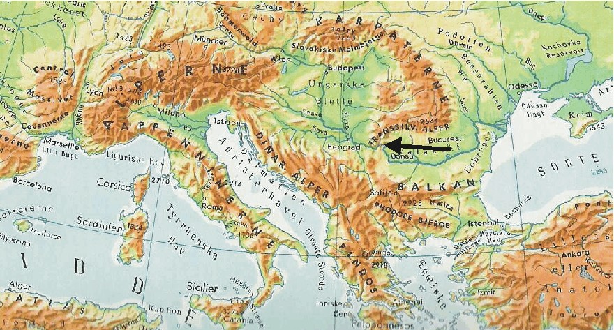
Map
showing the location of the Iron
Gate (black arrow) in south-east Europe.
An
indication of the benign climate of Roman times with a rather long immunity from
cold winters in Europe may be seen in the building between AD 101 and 106 of a
bridge with many stone piers across the River
Danube at the Iron
Gate in south-east Europe, between Serbia
and the Transylvian highlands in Romania
(cf. Lamb 1995).
The bridge was designed by Appolodorus of Damascus for the Emperor Trajan for efficient passage of the Roman armies and administration across the Danube, preceding Trajan's subsequent conquest of Dacia, a large region broadly corresponding to modern Romania and Moldova.
Trajan's bridge apparently stood for no less than about 170 years Lamb (1977, 1995). This must be considered an amazing fact, as in any recent century such a construction would rapidly have been carried away by river ice during a cold winter. In the end the bridge is said to have been destroyed by the Dacian tribes when the Romans later withdrew from this part of Europe (Lamb 1977, 1995).
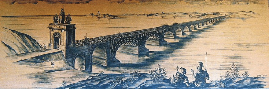
Artistic reconstruction of Trajan's bridge across the river Danube (source: Wikimedia Commons).
Trajan's
bridge was 1,135 m in length (the Danube is about 800 m wide at the place of
crossing), 15 m in width, and 19 m in height above the average water level. At
each end of the bridge was a Roman castrum,
each built around an entrance to the bridge. In other words, in order to cross
the bridge you had first to pass through a Roman military camp.
For the bridge's construction Appolodorus of Damascus used wooden arches set on twenty masonry pillars (made of bricks, mortar and pozzolana cement) that spanned 38 m each. The entire bridge was built quickly within two years only (between 103 and 105 AD), employing the construction of a wooden caisson for each pier. For more than 1000 years Trajan's bridge was the longest arch bridge ever constructed, in both total and span length, and it apparently survived for no less than about 170 years (Lamb 1975, 1977), before being demolished by the Dacian people. Although representing an impressive engineering feat, relative mild winters with little river ice presumably contributed to the long survival time of the bridge.
A
relief
on Trajan's
Column shows the Roman bridge across the River Danube (see figure below). Noteworthy
on this illustration are the unusually flat segmental arches on high-rising
concrete piers; in the foreground of the relief Emperor Trajan sacrificing by
the Danube can be seen.

The River Danube and the Kazan gorge at its narrowest point (left), and relief showing the Roman bridge across Danube on Trajan's Column in Rome (right). Source: Wikimedia Commons.
The
Iron Gate gorge(s) lies between Romania in the north and Serbia in the south. At
this point, the river separates the southern Carpathian
Mountains from the northwestern foothills of the Balkan
Mountains. The Romanian, Hungarian, Slovakian, Turkish, German and Bulgarian
names literally mean "Iron Gates" and are used to name the entire
range of gorges. The Romanian side of the gorge now constitutes the
Iron Gates natural park, whereas the Serbian part constitutes the Đerdap
national park.
The Great Kazan (kazan meaning "boiler") is the most famous and the narrowest gorge of the Iron Gate route (photo above): the river here narrows to 150 m and reaches a depth of up to 53 m (174 ft). Shortly downstream is the site where the Roman Emperor Trajan had the legendary military bridge erected between 103 and 105 AD, preceding his conquest of Dacia. On the right (Serbian) bank of the river a Roman memorial plaque (Tabula Trajana) commemorates Emperor Trajan's military road into Dacia. The Tabula was originally located 50 meters lower than now. The original site was flooded with the construction of a major hydroelectric dam in late 1960s and the monument was moved to a new position just above the waterline. On the opposite Romanian bank, at the Small Kazan, a statue of Trajan's Dacian opponent Decebalus was carved in rock from 1994 through 2004 (see photos below).
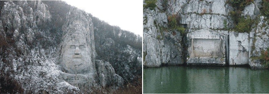
Rock carving showing Decebalus on the Romanian side of the Iron Gate (left), and a plate commemorating the roman Emperor Trajan on the Serbian bank (right). Source: Wikimedia Commons.
The
twenty pillars carrying Trajan's bridge were still visible in 1856, when the
level of the Danube hit a record low.
In
1979, Trajan's Bridge was added to the Monument
of Culture of Exceptional Importance, and in 1983 it was added to the Archaeological
Sites of Exceptional Importance list, and by that it is protected by
Republic of Serbia.
Click here to jump back to the list of contents.
90-168
AD: Claudius
Ptolemaeus
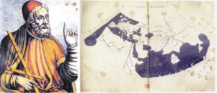
An early Baroque artist's rendition of Claudius Ptolemaeus (left). To the right is shown a 15th-century manuscript copy of the Ptolemy world map, reconstituted from Ptolemy's Geographia, indicating the countries of "Serica" and "Sinae" (China) at the extreme east, beyond the island of "Taprobane" (Sri Lanka, oversized) and the "Aurea Chersonesus" (Malay Peninsula).
Claudius
Ptolemaeus (AD90-168) was a Greek-Roman citizen, who lived in Alexandria,
working at the big scientific library.
He was a philosopher, mathematician, astronomer, geographer, and
astrologist. Much of the summary below is adopted
from different sources in Wikepedia
and from Rasmussen
2010, from where additional information is available.
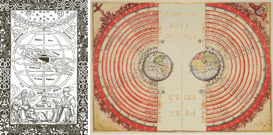
Ptolemy instructing Regiomontanus under an image of the zodiac encircling the celestial spheres (left). Frontispiece from Ptolemy's Almagest, (Venice, 1496). To the right an illustration of the Ptolemaic geocentric system by Portuguese cosmographer and cartographer Bartolomeu Velho, 1568 (Bibliothèque Nationale, Paris).
One
of the unique features of the Tetrabiblos,
amongst the astrological texts of its period, is the extent to which the first
book not only introduces the basic astrological principles, but also attempts to
explain the reasoning behind their reported associations in line with
Aristotelian philosophy. Chapter four in Tetrabiblos, explains the "power
of the planets" through their associations with the creative qualities
of warmth or moisture, or cold and dryness. Hence Mars is described as a
destructive planet because its association is excessive dryness, whilst Jupiter
is defined as temperate and fertilising because its association is moderate
warmth and humidity.
Click here to jump back to the list of contents.
476
AD: Collapse
of the Roman Empire
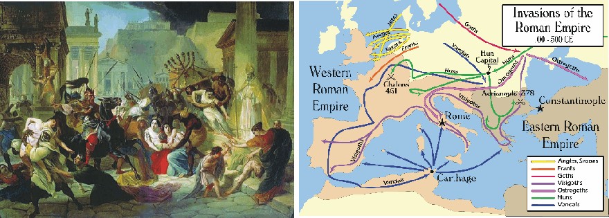
Karl
Bruillov's 'Sack of Rome' (left). Map of the "barbarian" invasions of
the Roman Empire showing the major incursions from 100 to 500 AD (right).
The
decline of the
Roman Empire refers to the gradual societal collapse of the
Western Roman Empire. This slow decline occurred over a period of four
centuries, culminating on September 4, 476 AD, when Romulus
Augustus, the last Emperor of the Western Roman Empire, was deposed by Odoacer,
a Germanic chieftain. The following text is based mainly on Büntgen
et al. (2011), Lubick 2011 and Wikipedia.
The
European Middle Ages following the decline of the Roman Empire is important, as
it witnessed the first sustained urbanisation
of northern and western Europe. Many modern European states owe their origins to
events unfolding in the Middle Ages; present European political boundaries are,
in many regards, the result of the military and dynastic achievements during
this tumultuous period.