Year 1800-1849 AD
-
1815: The year without summer. The Tambora volcanic eruption
-
1817: Royal Society of London on the retreat of Arctic sea ice
-
1824: Joseph Fourier suggests an explanation of global temperature
-
1830-1850: Famine and depopulation of the Scottish Highlands
-
1840: Louis Agassiz visits Blackford Hill in
-
1840: Arctic explorations becomes a national obsession in
-
1844-1848: Vernagtferner again advances into Rofental and ice dammed Rofen ice lake reforms
1800-1812:
Napoleons new Europe and scientific progress

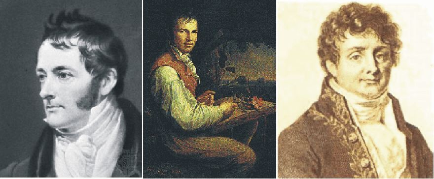
William
Henry
The political boundaries in Europe at the end of the 18th century and the constitutional arrangements within them were largely the legacy of medieval attempts at creating a pan-European empire. Germany was broken up into more than 300 different political units, ruled over by electors, archbishops, dukes, landgraves, city councils, counts, imperial knights, etc. What is now Belgium belonged to the Habsburgs and was ruled from Vienna, while Italy was divided up into 11 states, most of them ruled by Austrian Habsburgs or French and Spanish Bourbons. The Holy Roman Empire of the German Nation included Czechs, Magyars and half a dozen other nationalities. Poland was divided into three regions, ruled from Berlin, Vienna and St. Petersburg, respectively. Especially the Polish situation was to have consequences for the near future in Europe.
Between 1801 and 1806, following his victories over Austria and Prussia, Napoleon transformed the political, social and economic climate throughout the German lands. Each annexed territory was reorganised along the lines of French Enlightenment thought, rulers were dethroned, the Holy Roman Empire was dissolved, imperial counts and knights lost their lands, nonsensical borders were removed, caste privileges and other restrictions were abolished, and in their place came new institutions mounded on the French Pattern. The ending of feudal practices gave agriculture a boost, and the removal of tolls and frontiers liberated trade. The confiscation of church property was followed by the building of schools and the development of universities. Napoleon became very popular in most of Europe with the middle class, peasants, Jews, as well as with progressive intellectuals, students and writers. Many new scientific ideas and hypotheses were put forward in this new atmosphere of freedom.
With
the victories of
Science
in many other countries in
One
example of this is the English chemist William Henry (1775-1836), who in 1803
described his results with experiments on the quantity of gases (e.g. CO2)
absorbed by water at different temperatures and under different pressures. His
results are known today as Henrys law. This fundamental law among other
things describes how the solubility of CO2 in water decreases with
temperature.
Shortly
after this, in 1807, 1817, 1822, 1824 and 1827, the French mathematician and physicist
Jean Baptiste Joseph Fourier proposed the hypothesis that the atmospheric
temperature would depend, among other things, on the amount of atmospheric CO2.
This resulted in the first broad scientific interest for CO2 as a
chemical substance, and various scientists began measuring the actual
concentration of atmospheric CO2. This was seen to vary over time,
and using Henry's law, such variations was explained by small variations in the
sea surface temperature, controlling the solubility of CO2 in ocean
water. Also knowledge on various geological and biological processes were
slowly emerging as potentially important for the variable atmospheric CO2 content. In
addition to proposing the CO2 hypothesis, Jean Baptiste Joseph
Fourier actually became best known for initiating the investigation of
mathematical Fourier series and their application to problems of heat flow.
1801:
The First Battle
of Copenhagen
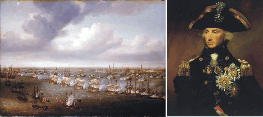
The Battle of Copenhagen, as painted by Nicholas Pocock (left). Vice Admiral Horatio Lord Nelson (right).
Before
the
For
On
the very day the treaty was ratified in
The
British government rapidly decided to take out the Danish fleet, which
was strategically well placed at the entrance to the Baltic. In
early 1801, a powerful British fleet was assembled at Great Yarmouth under the command
of Admiral Sir Hyde Parker with Vice-Admiral Lord Nelson under him. The British
fleet sailed from Yarmouth on 12 March 1801.
According
to the treaty, Denmark should expect assistance from both the Russian and the
Swedish fleets, which together with the Danish fleet would be able to muster a
formidable force with no less than 123 ships of the line (battleships). So
things did not look so bad for Denmark, after all.
Winters
were generally cold during this part of the Little Ice Age, and the Danish
government realized that there would come no assistance from the Russian fleet,
as it still was locked by solid sea ice in its bases Kronstad and Reval, near
St. Petersburg. At the same time, promised naval support for the Danes from
Sweden did not arrive perhaps because of adverse winds. The Prussians had only
minimal naval forces and too could not assist in any way. On 30 March, the
British force passed through the narrows between
On the afternoon of 1 April 1801 Nelson took his ships south in Øresund and anchored off the southern tip of the Middle Ground Shoal, south-east of Copenhagen, ready to attack the following day. The next morning, 2 April, there was a favourable wind to take the British ships north past the anchored Danis warships and floating batteries.
This was a hazardous enterprise. The water was shallow and only a single channel with deeper water existed in this particular part of Øresund. The exact position of this channel was not known, and the Danish had understandably removed all markings. Nelson's pilots refused to serve for fear of causing the whole fleet to be grounded (Harvey 2007). Captain Murrau in the Edgar then led the way. The previous night he had been sent by Nelson to take soundings in a muffled boat right under the nose of the Danish ships. Eventually, several of the British ships grounded during the battle, a situation which nearly ended in British defeat.
Some of the
Danish ships were in poor condition,
no more that grounded gun batteries, but at the northern end of the channel
between Copenhagen and the island Saltholm to the east there were two strong
forts. In total, quite a formidable Danish defence line. The battle that followed was hard. As the
morning of the battle wore on, some Danish batteries ceased firering and a few
of these
surrendered, while others continued to put up a strong resistance. Many British
ships were being badly mauled, and slowly Nelson's situation was beginning to
look critical. Unlucky for the Danish defence, however, the Danish flagship Dannebrog
then caught fire and began drifting down the Danish line. This
sight had negative influence on the Danish efforts, and even more so when Dannebrog
exploded later in the afternoon. 3 PM the Danes
agreed to a cease-fire under the threat of Nelson to burn the captured Danish
floating batteries with the Danish seamen still onboard.
Nearly 1100 km to the north-east, at St. Petersburg, Tsar Paul of Russia had been assassinated by strangling nine days earlier, on 24 March, an act widely attributed to the British secret service. At least, the intimate knowledge on the plot later disclosed by the British ambassador in St. Petersburg suggests British passive complicity (Harvey 2007).
The
new Tsar, Alexander I, immediately reversed Russian foreign policy, releasing
British merchant ships which had been seized, and signed an agreement with
Britain under which British goods were again allowed to sail in Baltic waters. In summer, news of such a momentous event, travelling by sea,
would have reached Copenhagen long before the battle on April 2. However, in the winter
1800-1801 the Russian ports were still ice-bound, and for much of their journey
couriers had to take a longer, overland route.
It
is not entirely clear when the news about the assassination of Tsar Paul arrived
in Copenhagen, but it has been suggested that it came while the battle was still
raging, and influenced subsequent events. Had the the winter 1800-1801 not been so cold
and the intelligence therefore received earlier in Copenhagen, the whole melancholic
affair today known as the First Battle of Copenhagen (Danish: Slaget
på Rheden) might have been avoided (Adkins and
Adkins 2006).
And had the British Navy no intelligence on the Russian fleet still being
ice-bound in March 1801, the First Battle of Copenhagen presumably would not
have been fought at all. Chances are that
the Second Battle of Copenhagen
had not been fought, either.
1805:
The
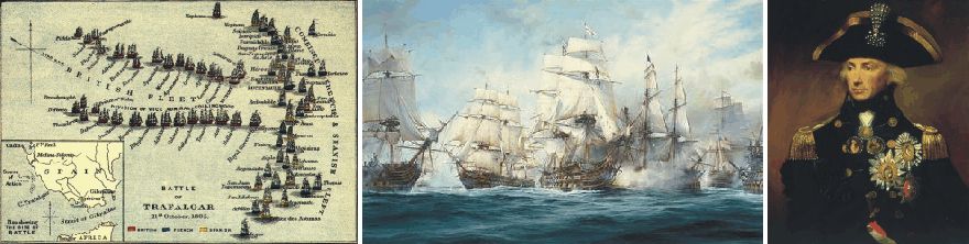
Battleorder at the onset of the Battele at Trafalgar, southern Spain (left). Horatio Nelson's flagship Victory breaking through the French battleline at 1.00pm 21st October 1805. Painting by Robert Taylor (centre). Horatio Nelson (right).
On
the morning of
The
result of the following battle is well known. The British fleet under Admiral
Horatio Nelson defeated the Franco-Spanish fleet, in the process taking no less
that 16 battleships as prizes. By this feat, the French treat of invasion in
When
crossing the French line in his flagship Victory, Nelson was shot by a French
Mariner called Guillemend, placed as sharpshoter in one of the masts of the
nearby battleship Redoutable (see picture above). Later in the afternoon, Nelson
died of his wound. He traveled back to
Nelson’s seamanship and prescience, however, remained to the last. While lying in his bed after being treated for his wound he noticed a growing swell, in spite of the fine weather. This alerted him that bad weather was on the way, threatening all ships by driving them by the wind on to the nearby lee shore. His last order was therefore to anchor the British ships to avoid this coming disaster.
Nelson’s
second in command, Collingwood, however decided to ignore Nelson’s orders to
anchor, partly because some of the anchors aboard British ships had been lost in
the fighting, and partly to sail as far as possible from the dangerous lee shore
of
It the following night the British fleet with all prizes sailed straight into a fateful storm. Colossal waves battered the ships, many of them already crippled, rolling about helplessly with their gaping holes from the battle. Many of the captured French ships sank behind the ships towing her, or had to be cut adrift and then stranded on the shoals near the coast.
At dawn the storm continued unabated, and more French prizes went aground, sank or had to be destroyed. The captured French Admiral Villeneuve presumably saw with considerable relief that his ships now would not join the British fleet. The storm continued for three days, and no less than 12 of the original 16 prizes were lost. All British ships managed to limp back home (Harvey 2007).
The
Battle of Trafalgar was a great British naval victory. But it would have been
even more significant, had these 12 French battleships not been lost during the
following storm, but instead successfully been incorporated into the British
navy. This would even more significantly have changed the naval balance between
the
Click here to jump back to the list of contents.
1807:
The Second Battle of Copenhagen
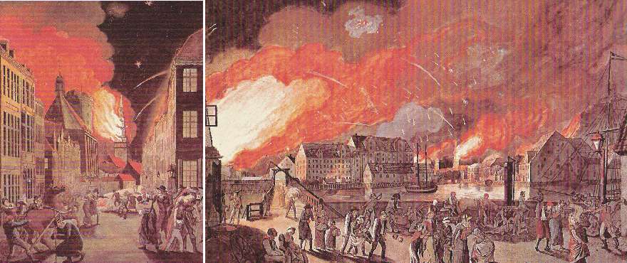
The culmination of the bombardment of Copenhagen in the night between 4 and 5 September 1807 (oil paintings by C.V. Eckersberg).
In Europe, the political landscape had changed again in 1807. On 14 June a Russian army had been defeated by Napoleon at the Battle of Friedland, and on 7 July Napoleon met the Russian Tsar Alexander I at Tilsit, a small town on the Polish-Lithuanian border. Here a peace treaty was signed between France and Russia, and it was obvious that with Russia under the sway of Napoleon the Continental System would soon begin to have a serious effect on Britain (Adkins and Adkins 2006). Of more immediate concern for Britain was the planned amalgamation of the French and Russian fleets, a part of the peace treaty meant to be hidden. The combined French-Russian fleet were then to be increased by more shipbuilding and also by seizing the fleets of Portugal and Denmark, both neutral states with significant fleets.
The secret treaty was known almost instantly in Britain, and the goverment realised that it had to act quickly to pre-empt Napoleons plan. The most dangerous part of the treaty lay with the powerful Danish fleet. If Napoleon gained control of Denmark, Britain would be excluded from essential trade with the Baltic states, and the Danish fleet could be used to renew the possibility of invading Britain (Adkins and Adkins 2006). Within weeks 17 battleships and 21 frigates commanded by Admiral Lord Gambier sailed for Copenhagen as the first wave of an expeditionary force. Other batteleships, frigates and transports for 29,000 troops were to follow.
The lessons of the First Battle of Copenhagen in 1801 had apparently been taken to heart. The expedition was dispatched more quickly this time, and did not rely on naval fire-power alone. Troops were landed 16 August 1807 north of Copenhagen, and quickly laid siege to the city of Copenhagen, to back up British demands that the Danes surrender their fleet and naval stores. The British demands were rejected after diplomatic negotiations by the Danish Crown Prince. The Danish fleet was not prepared for a major battle, and most ships was still laying in the harbor of Copenhagen.
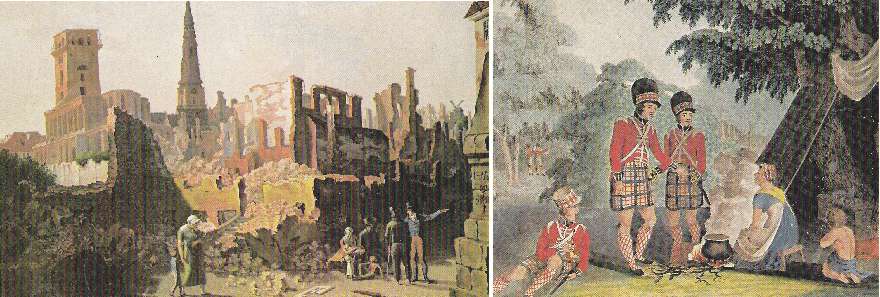
Gråbrødre Plads in Copenhagen, after the bombardment in September 1807 (left). Scottish soldiers in their camp shortly west of Copenhagen (right).
At the evening of 2 September the British began to bombard Copenhagen, both from land and from the sea, using bombs and rockets. The British army and navy had a new weapon at their disposal, Congreves rocket, which could fire about 3,000 m, and later was to be used against the United States in the War of 1812. The bombardment continued with short breaks for several days, and culminated in the night between 4 and 5 September, where about 6,000 bombs and rockets hit the city (see illustrations above). Large parts of the city was burning, and more than 1600 persons lost their life. In total, about 14,000 bombs and rockets were fired at the besieged city (Lindeberg 1974).
The bombardment continued through 5 September, but was then interupted because of new negotiations. The next day, 6 September, the Danes agreed to give up their fleet and naval stores in return for a British withdrawal and an exchange of prisoners. The siege and bombardment also furnished the name for the horse that the Duke of Wellington would ride at the Battle of Waterloo in 1815. In addition, together with the partly climatically influenced First Battle of Copenhagen in 1801, this was the end of Denmark's role as a strong naval nation.
Click here to jump back to the list of contents.
1808:
Danish royal castle Koldinghus destroyed by fire
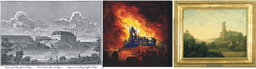
Danish royal castle Koldinghus in Jutland before 1808 (left). Koldinghus on fire the night between 29 and 30 March 1808 (centre). Painting by Hans Harder (1824) showing the ruin of Koldinghus after the fire.
Little Ice Age climatic and political induced disasters were not to end for Denmark by the two lost battles of Copenhagen in 1801 and 1807, respectively, as the unfortunate fate of the royal castle Koldinghus testifies.
Koldinghus
is the last of the ancient royal castles in Jutland, the western part of
Denmark. The castle was originally founded by king
Christoffer I (1252-1259) in 1268, but the oldest remaining part of
buildings was built by king
Christoffer III (1440–1448). Later king
Christian I (1448-1481) and king
Christian III (1534-1559) built other parts of the castle. Around 1720, king
Frederik IV (1699-1730) contributed with rebuilding around 1720, resulting
in a Baroque architecture.
The
effects of war
between Britain and France were also felt in the town Kolding
in southeastern Jutland. Following the
second British attack on Denmark and Copenhagen in 1807, Denmark allied
herself with France and Spain against Britain and Sweden. About 30,000 French
and Spanish soldiers were send to Denmark for support. Part of the plan was that
these troops should assist in a campaign to recuperate the Scandian lands (southern
Sweden), which was lost to Sweden following the
Danish-Swedish war in 1658. When the French and Spanish soldiers arrived,
the old castle Koldinghus was opened as quarters for some of these troops. In
addition, it became the headquarters for the commander-in-chief of the
expeditionary troops, the French marshal Jean-Baptiste
Bernadotte.
The
winter 1807-1808 was cold
compared to modern standards, and temperatures plunged to values below what
especially the Spanish troops were used to. Not surprisingly, they attempted to
heat the castle correspondingly by firing zealously in the castles fireplace.
The fire risk represented by the soldiers quite rightfully became a
worry at the Danish castle administration, and, eventually, in the night
between 29 and 30 March 1808 fire broke out. To fight the raging fire Marshal
Bernadotte had his men to form a chain down to the castle lake. The lake,
however, was frozen over so that a hole had first to be broken in order to get
water. In the end, it turned out to be impossible to save the castle.
Posterity
has been inclined to place the blame for the fire entirely on the Spanish
soldiers, and it is entirely likely that they, being unused to the Nordic Little
Ice Age winter, fired up all too enthusiastically in the castle's
fireplace. Another contributing reason, however, might simply be that the
maintenance of the castle’s chimneys had been neglected. Whatever the real cause,
Jutland's last royal castle, which in 1808 still stood in the Baroque form it
had attained through Frederik IV's rebuilding in the years around 1720, was
lost.
Koldinghus was never rebuild as a royal castle, and quickly became one of the romantic ruins which were widely admired in the 19th century. The planned, combined military effort against Sweden was never initiated, partly because of lack of suitable transports, and partly because the Spanish troops decided to regroup at more southerly latitudes. Instead of attacking Sweden, marshal Jean-Baptiste Bernadotte later (1810) was offered and accepted the position as new Swedish king under the name Karl XIV Johan.
Click here to jump back to the list of contents.
1808:
New diets introduced in Norway

Martin Richard Flor (left). Lichen Cetraria islandica (centre). Fen Polypodium vulgare (right).
The war with Britain and especially the Second Battle of Copenhagen in 1807 had serious effects for the Danish-Norwegian kingdom. Denmark lost its maritime control over the seas around Denmark, and most connections to the Norwegian part of the Danish-Norwegian kingdom were interrupted during the British blockade 1808-1811. Climate conditions at that time were generally unfavourable for farming, with low Little Ice Age air temperatures, especially during the growing season. This rapidly brought Norway into a very difficult situation, as people in Norway could not any longer rely on importing farming products from Denmark. This sad state of affairs has been described by the Norwegian author Henrik Ibsen (1828-1906) in his famous epic poem Terje Vigen from 1861.
The Danish king Frederik 6 and the government in Copenhagen therefore decided to investigate if alternative diets were available for the population in Norway. This resulted in sending the Danish botanist Martin Richard Flor (1772-1820) to Norway. Martin Richard Flor had previously documented his interest for different plant types as alternative, potential sources for human nourishment. During spring 1808 he spent about two months travelling around in southern Norway, to investigate if useful plants were available in sufficient quantities.
Martin Richard Flor actually identified a number of alternative food sources in Norway, e.g. the lichen species Cetraria islandica (see photo above), and the fen type Polypodium vulgare (photo above). The Norwegian population, however, was not entirely enthuiastic about his suggestions for new diets, and he was rapidly nicknamed the 'moss-priest'.
Martin Richard Flor was not discouraged by this, and contributed towards improving the general education of all people, both in Denmark and in Norway. Among other feats, he published the first flora of Norwegian plants. He also became involved in the establishment of the society Selskabet for Norges Vel (now: Det Kongelige Selskap for Norges Vel) in 1809.This society rapidly developed into a Norwegian shadow government, to ensure that Norwegian interests in matters relating to the disrupted Danish-Norwegian kingdom were taken care of. In 1810 the society initiated the establishment of the economical foundation for a university in Norway. In 1811 Frederik 6 approved of the plans, and Norway's first university became a reality in Christiania (now Oslo, University of Oslo). Martin Richard Flor was considered as a candidate for Professor of Botany at the new university, but was instead appointed as Senior Lecturer (lector botanices). As such, he was involved in the establishment of both a botanical garden and a Botanical Museum in Oslo.
Click here to jump back to the list of contents.
1812:
Background for Napoleon's Russian campaign
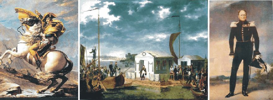
The two emperors
Napoleon (left) and Alexander I (right) negotiating the Tilsit Treaty in a pavilion set up on a raft in the middle of the
Niemen River, beginning 25 June 1807.
In 1806, Napoleon won a conclusive battle against
In
November 1806 the Holy Synod of the Russian Orthodox Church issued a
denunciation of Napoleon, accusing him of conspiring with evil people against
the Christan Faith, due to Napoleons declaration of his regard for Islam. Russia
therefore launched a military crusade against him. This initiative was cut short
by Napoleon routing the Russian army at Eylau (January 1807) and at Friedland
(June 1807). Tsar Alexander I of
Cracks in this alliance,
however, rapidly began to show. Especially Napoleon's creation of the Grande Duchy of
Caught
up by the internal dynamics of this development, Napoleon decided to strike
first, and began a relentless build-up of forces through the autumn and winter
of 1811 and into the spring of 1812. The army Napoleon was assembling would be
large by any scale, including soldiers from almost every nation of
Click
here to jump back to the list of contents.
1812:
Napoleon's Russian summer campaign
In
western
The
Russian army was no happier than the French, and its troops were in a state of
dejection as they retreated towards
The battle of Smolensk had also demonstrated the unpleasant fact to Napoleon, that the individual Russian soldier did not lay down his arms even in very difficult situations. 129 years later Adolf Hitler would make the identical observation. The French were dismayed by all this. This was not how war was supposed to be. In addition, these discomforts were added to by the fact that the Russians had adopted a new tactic now that the invaders were in the Russian homeland proper. They evacuated the entire population as they retreated, leaving towns and villages deserted and burnt down. It became increasingly difficult for the French army to find provisions.
Napoleon realised that he could not stop where he was, and as he would not retreat for political reasons, he could only advance in the hope of eventually obtaining a decisive military victory over the Russians. If not before, the Russians would surely make a stand in defence of their old capital Moscow. Based on existing knowledge on climate in western Russia, Napoleon at that time expected at least two months of decent campaigning weather ahead.
The mood at Russian headquarters was hardly better, even though the general situation was changing in their favour. The retreat was a good deal less orderly than before, and the Russian armies were now leaving behind them a trail of abandoned wagons and dead or dying men and horses. Like the French, the Russians were disturbed by the inhumane turn the campaign had taken. The ongoing retreat meant that discipline were fast breaking down, and everybody was on the lookout for traitors. All this was having a detrimental effect on the army and Barclay's authority.
In St. Petersburg Tsar Alexander found the general mood depressingly defeatist, and decided that the Russian army needed a new commander instead of Barclay. He was hard pressed by the public opinion to choose Field Marshal Mikhail Ilarionovich Kutuzov as Barclay's successor. Alexander himself was not to happy about this, as he considered Kutuzov both immoral and incompetent. His sister Catherine, however, urged him to bow to the inevitable, and Kutozov was appointed 20 August 1812. Kutuzov declared that he was going to save Moscow, and set off to find his headquarters.
After assessing the state of the Russian army Kutuzov suddenly felt that he could not face Napoleon, whose strength now was gauged at 165,000, down from the original 450,000. The Russian summer had taken its toll. Kutuzov therefore decided to continue the retreat initiated by Barclay two months before. Perhaps he also suspected Napoleon to be a superior general to himself. On 3 September Kutuzov inspected defensive positions found near the village of Borodino, about 100 km west of Moscow. Here he was going to make a stand.
Kutuzov took up entirely defensive positions without any tactical possibility of gaining the initiative. Luckily for him, Napoleon had just caught a cold with an associated attack of dysuria, and was in anything approaching his usual form. In fact, Napoleon was going to deliver probably the worst performance of his entire military career. The invading French army was now down to 126,000, while Kutuzov had about 155,00 men under his command.
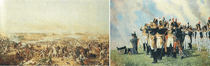
The Battle at Borodino 6 September 1812 (oil painting by Hess), with Napoleon watching from the Shevardino Redoubt (oil painting by Vereschagin).
The first large battle during Napoleon's Russian campaign began in the morning of 6 September 1812. Before this battle, both armies had lost more than half their original strength during eight weeks of Russian summer. The battle of Borodino was a hard fought battle with several Russian counterattacks, but slowly the French was getting the upper hand due to its superiority on the tactical level, and the Russian army had to retreat. The battle of Borodino was the greatest massacre in recorded history, not to be surpassed until the first day of the battle at Somme in 1916. Recent estimates give a total of about 73,000 casualties, 45,000 Russian and 28,000 French including allies.
Kutuzov's army was now in no condition to give battle on any positions, however strong. He therefore fell back to the village Fili west of Moscow, initially announcing that he would fight in front of Moscow to the last drop of blood. At the following council of war in Fili, however, he took the decision to abandon Moscow to Napoleon, to preserve the Russian army in being, a scene memorably portaryed in Tolstoy's War and Peace. The Russian army therefore continued its retreat through the Moscow to the consternation of the inhabitants. Kutuzov then turned south and later southwest, setting up a fortified camp for his army near Tarutino, about 120 km SW of Moscow.
The village Fili (now a suburb of
Click here to jump back to the list of contents.
In the afternoon of 14 September, what was left of the Grande Armée entered Moscow. Napoleon took up residence at the Kremlin the following day. About two-thirds of the 270,184 inhabitants had left, and the remainder were hiding in their homes. Nobody with an official status was left to take care of a formal surrender and make arrangements for feeding the soldiers, as would normally be the case in a civilised war. To make things even worse, before leaving Moscow, the city commander Count Rostopchin had ordered his Police Superintendant Voronenko to burn not only the remaining supplies, but everything he could. Voronenko and his men set to work, presumably assisted by the city's criminal elements. The fire raged out of control and spread to several districts of the city. In the morning of 16 September flames were lapping around the walls of Kremlin, and Napoleon had to evacuate himself and take up residence in the Petrovsky Palace, a few kilometres outside Moscow.
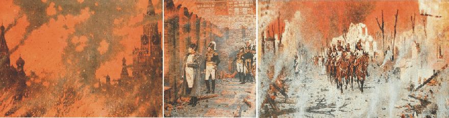
Moscow burning 15-18 September 1812. On the 18 September Napoleon returns to Kremlin after having evacuated himself to the Petrovsky Palace outside Moscow. Oil paintings by Vereschagin.
After three days the fire began to abate, and on 18 September Napoleon rode back into Moscow. Two thirds of the city was destroyed by the fire, robbing him of a wealth of material resources. And there was still no delegation formally surrendering Moscow to him. Even worse, Tsar Alexander still apparently did not understand that Russia was defeated, and therefore had no ambitions of making peace with Napoleon. It was all very frustrating.
Napoleon now had to consider taking up winter quarters in Moscow. Alternatively he would have to retreat with his back home, a move which for political reasons was difficult. So for the time being, he choose to remain in Moscow, hoping that Alexander finally would come to his senses.
Napoleon had studied the available weather information, which told him that it normally did not get really cold until the beginning of December, so he did not feel any sense of urgency. What he did not realise, was how sudden low temperatures may come if a high pressure area settles over eastern Europe, pumping arctic air masses south across Russia, where the lack of high mountains leave the whole country open for arctic air masses. In addition, he had no experience of temperature being only one factor, but that the wind strength also had to be taken into account.
Early October 1812 the weather remained to be fine and warm, and Napoleon was teasing Armand Caulaincourt, his finest civilian aide, about his anxiety about the winter climate. On 13 October, however, the weather suddenly turned cold, and Moscow was covered in a blanket of thin snow. Presumably this was a meteorological surprise to Napoleon, and it rapidly made him make up his mind. The same day he declared that the army would leave as rapid as possible, and take up winter quarters further west, where well-stocked bases were at hand in Minsk and Vilna. Napoleons army left Moscow 20 October.
Click here to jump back to the list of contents.
1812:
Napoleon's retreat from Moscow
The actual armed forces at Napoleon's disposal as he left Moscow numbered no more than 95,000, and probably less. Marchal Kutuzow was still camping passively SW of Moscow, reinforcing his army to about 97,000 men. He was, however, still in no hurry to engage in regular warfare. So while Napoleon was retreating west towards Smolensk along the Moscow road, Kutuzov did not seriously attempt to cut across their line of retreat, even though he was excellently placed to do so.
The French retreat was slow, mainly due to lack of horsepower. The shortage of fodder had debilitated the horses, and they were growing too week to pull the guns and wagons. Part of the problem was that Napoleon saw himself carrying out a tactical withdrawal rather than a retreat. Therefore he refused to abandon a proportion of their guns to liberate horses and thereby save time. This determination not to loose face would cost him dear. As well as slowing their progress, all this had a demoralising effect on the French troops, marching down a devastated road, seeing only abandoned equipment, human and animal corpses. Kutuzow was still following south of the French army, but resolutely opposed to any suggestions from his generals to make an offensive move.
The good news for the French was that the weather was magnificent, and that the early snow in Moscow presumably just was a meteorological mishap. On 31 October, at Viazma, Napoleon therefore ridiculed those who had been attempting to scare him with stories of the Russian winter. The weather remained fine during the first days of November 1812, until 3 November, which was to be the last warm day. The wind turned north and the night between 4 and 5 November brought with it a rapid drop in air temperature. On 6 November the French retreat was entering a new phase. It began to snow, and in short time it lay half a meter thick on the ground. The drop in temperature had not been that great, probably not exceeding -10oC. But the French army was not used to or dressed for cold weather. There was no such thing as a winter uniform, since in those days armies did not fight in winter. The cold also provided the last straw for many of the remaining horses. The meteorological change early November 1812 had a profound effect on the whole French army.
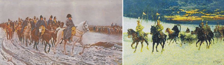
Napoleon and his army retreating in western Russia early November 1812.
Also the Russian army under Kutuzow was affected by the cold, and food and clothing was equally scarce. The war now grow even more vicious than before, and captives had become an unwelcome encumbrance to both sides. Many prisoners, French or Russian, were simply despatched with a bullet to the head.
When Napoleon 9 November reached Smolensk, the wind was still northerly and air temperatures were down to -15oC. On 14 November, they sank to -28oC. His army was now reduced to about 35,000 men. Kutuzow made some attempts at intersecting Napoleons further retreat towards Minsk, but without substantial success. 22 November Napoleon reached Tolochin, where he was informed that other Russian forces just had taken Minsk further to the west. What was left of the French army was surrounded. Napoleon, nevertheless, managed to extricate himself from this impossible situation by fainting an attack towards south, while his engineers at the same time was constructing two bridges across the frozen river Berezina, which was crossed 27-28 November.
The following two days may have been among the worst of the entire retreat. When Napoleon reached Pleshchenitse on 30 November, a temperature of -30oC was recorded be Dr. Louis Lagneau (Zamoyski 2005). Frostbite was widespread among the tired and hungry soldiers. Selfishness reached new heights. Now that Napoleon had managed to get beyond his reach, Kutuzov felt even less inclined to force the pursuit than before. Also his army was in a terrible condition. His main force, which has marched out of Tarutino 97,000 strong one month before, was now reduced to 27,000 men due to the cold, according to his own figures (Zamoyski 2005).
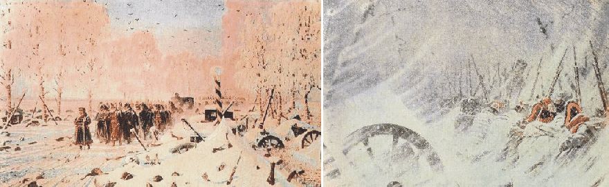
Retreat of the French army in western Russia, mid- and late November 1812. Oil paintings by Vereschagin.
On the evening of 5 December, at Smorgonie, Napoleon decided that it was time for him to go back to Paris, and take control from there. He called together his marshals and apparently apologised for his mistake of having remained in Moscow for too long. He then set off into the night. The Imperial Mameluke, Roustam, later reported that the wine in Napoleon's carriage froze that night, causing the bottles to shatter. On 6 December the temperature fell even more, reaching -37.5oC according to Dr. Louis Lagneau.
This
was the end. On 9 December the main mass of the French army turned up at the
gates of Vilnia. Vilnia, however, could not be hold, and the retreat had to
continue towards the starting point along the river Niemen. The weather
continued bitterly cold, with daytime temperatures around -35oC. The
French commander Murat realised that the line of Niemen could not be held, and
had to retreat all the way to first Kö
It was only when the French retreat finally came to a stop towards the end of January 1813 that the true scale of the disaster began to emerge. June 1812 somewhere between 550,000 and 600,000 French and allied troops have been assembled along Niemen. Only about 120,000 came out of Russia in December 1812, including substantial reinforcements received after the invasion was launched 22 June. Presumably at least 400,000 French and allied troops died during the campaign, less than 100,000 in battle. On the Russian side is has been estimated that up to 400,000 soldiers and militia died, about 110,000 of them in battle.
The extremely cold winter November-December 1812, in combination with the previous warm summer July-August 1812 had been devastating for the whole military operation on both French and Russian side, and were to have lasting effects on Europe's political future.
The catastrophic outcome of the Russian campaign sealed Napoleon's fate. Not only did it cost him 300,000 of his best French soldiers (today this would compare to a loss of 700,000 men), but it also punctured the aura of superiority and being invincible that has been surrounding Napoleon's person. Few saw this more clearly than the German patriots in Prussia, who had been suffering under the humiliation of French dominion. On 28 February 1813 an alliance was concluded between Russia and Prussia, and two weeks the latter declared war on France.
Click here to jump back to the list of contents.
1813-14:
The invasion of France
In astonishingly short time Napoleon managed to raise a new army of 200,000 men, and rapidly regained his old self-confidence. In April 1813 he lead a huge counter-offensive with his new army into the Preussian heartland towards Dresden. His strategy was to retake Berlin and relieve Danzig, thus rescuing the 150,000 French troops sourrounded along the Vistula. At this time, the minor German princes still supported him.
At Lützen Napoleon defeated the combined Russo-Prussian force on 2 May and once again at Bautzen 20 May, but all to no avail. Sweden joined the coalition against Napoleon and Britain contributed money. And as Napoleon's enemies grew in strength, his remaining allies began to waver. On 12 August Austria declared war on France. Napoleon responded by defeating a combined Russian-Austrian army 26 August outside Dresden. On 16 October 1813 Napoleon faced the combined forces of the new coalition at Leipzig, being outnumbered by two to one. Napoleon nevertheless held his ground for long, but finally had to fell back across the Rhine early November 1813.
In the spring of 1814 Napoleon fought his perhaps most brilliant campaign against the invading armies on French soil. In January 1814 the Prussian army under the generals Blücher and Gneisenau crossed the river Meuse and penetrated 120 km into French territory. In a fierce winter blizzard, Napoleon attempted to work his way around the Prussian's rear, nearly capturing Blücher and Gneisenau, and forcing their army to retreat towards La Rothiére (Harvey 2006). The allies had great trouble concentrating one big army to face and defeat Napoleon, as the cold winter 1813-1814 made it difficult to keep any big army supplied on French soil during the winter. The allied armies therefrore remained seperated and vulnerable.
However, this development and other French victories were unable to do more than delay the evitable end. Paris capitulated 31 March 1814, and Napoleon was force to abdicate on 6 April, less than 18 month after leaving Moscow. He was exiled to the island of Elba off the Italian coast. One year later, on 1 March 1815, he landed in France and took power once again. On 18 June 1815 he was defeated at Waterloo by a combined British and Russian army under Wellington. Even at this final confrontation, Napoleon proved himself to be an outstanding general. The final outcome of the battle was, in a phrase used by the Duke of Wellington in describing his victory at Waterloo, "the nearest run thing you ever saw in your life" (Massie 2005). Napoleon was then exiled to St. Helena in the southern part of the Atlantic Ocean, where he died 5 May 1821.
France, a state at least as powerful as Britain before the industrial revolution, was crippled politically and economically for decades after 1815. For long, it remained a largely agrarian country, and its own industrial revolution was seriously posponed. In total, France was considerably worse off economically and more backward politically in 1816 than in 1788. The French industrial revolution had been limited to military-related manufacturing, which was not particularly efficient. While Britain was undergoing a significant industrial revolution during this period, France in many respects fell way behind, and ceased to be a major economic and political rival to Britain until the late 20th century.
In Europe most nations in 1816 were far less progressive and democratic than in 1788. The Napolean period and its final outcome had set the clock back, not forward, except in one respect: the expansion of the role of the central state, fuelled by the military imperative. This was a legacy that was to last well into the 20th century.
Click here to jump back to the list of contents.
1815:
The year without summer. The Tambora volcanic eruption
The
April 1815 eruption of Tambora was probably the largest eruption in
historic time. About 150 cubic kilometres of ash were erupted. This is about 150
times more than the 1980 eruption of
An estimated 92,000 people were killed by the
eruption.
About 10,000 direct deaths were caused by bomb impacts, tephra fall, and
pyroclastic flows, the rest indirectly by starvation, disease, and hunger. The
eruption apparently lowered average world temperature by about 0.5-0.7°C over a
period of 2-3 years. The 1815 eruption of Tambora was followed in North America
and
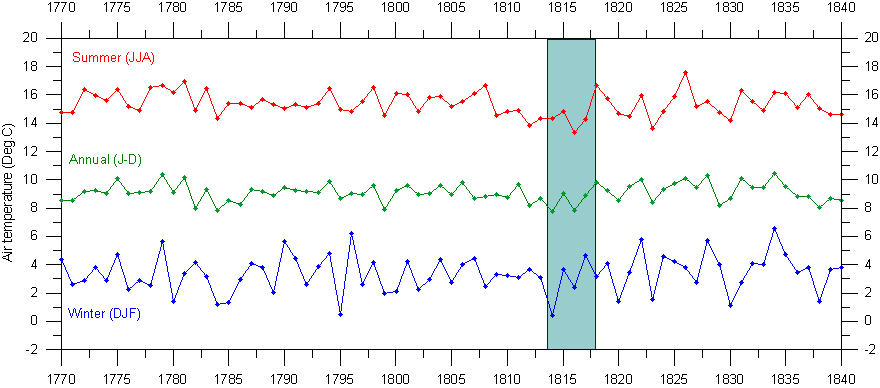
Central England temperature series 1770-1840. The length of the cooling effect of the Tambora 1815 eruption is indicated by the blue bar. These graphs has been prepared using the composite monthly meteorological series since 1659, originally painstakingly homogenized and published by the late professor Gordon Manley (1974). The data series is now updated by the Hadley Centre and may be downloaded from there by clicking here. A graph showing the entire Central England temperature series since 1659 can be seen by clicking here.
Click here to jump back to the list of contents.
1816:
The cold summer in New England
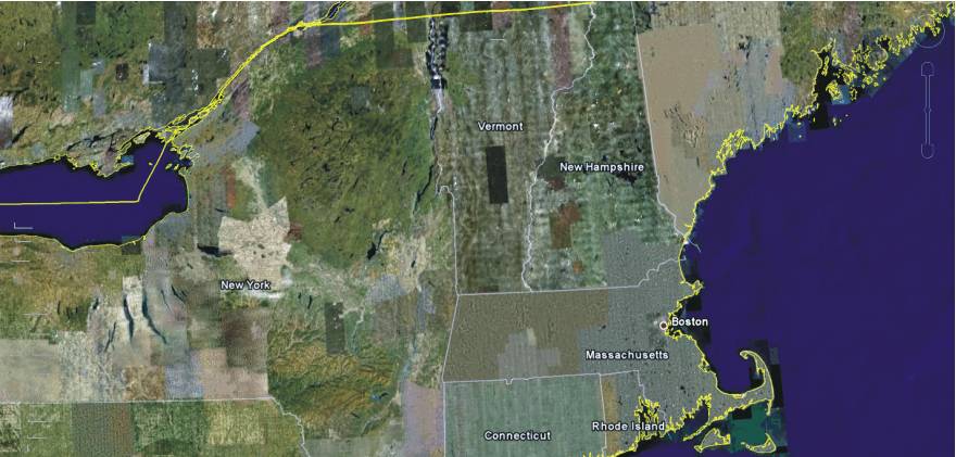
Northeastern USA with New England as seen in Google Earth.
The coldest summer known to have been experienced in New England was that of 1816 (Perley 2001), the year after the big Tambora volcanic eruption in 1815. About 150 cubic kilometres of ash were erupted high into the atmosphere by this eruption.
In the years following the eruption air temperatures were low in many parts of the world, including New England, where 1816 became known as the 'poverty year' (Perley 2001). Many of the crops proved a failure and it seemed at the time as if nothing would be produced. In New Hampshire but little pork was fattened on account of the scarcity and consequent great cost of corn, and the people used mackerel as a substitute for it. There was frost and snow in all the summer months, and in the northwestern part of New England a severe drought prevailed, which added to the disastrous effects of the season.
Perley (2001) states that 'Many people have endeavoured to ascertain some cause for the extraordinary nature of this summer, though no opinion has gained much ground. A large number of the people of that time believed that the large spots which appeared on the sun's disk that spring lessened the number of rays of light and consequently the earth was to that extent cooler than usual. The spots were so large that, for the first time in their history, they could be seen without the aid of telescope.....They were seen by the naked eye for several days, beginning on the third of May, and, reappearing on June 11, they were again seen for a few days only'.
Clearly people also at that time (1816) were skilled observers of nature. However, the organized international communication of news was apparently not equally well developed. Clearly few people, if any, in New England had received information on the Tambora eruption the previous year.
May 1816 became both dry and unseasonably cold. At Chester, New Hampshire, newly ploughed land froze hard on 15 May, and snow fell in some of the northern parts of New England (Perley 2001). In the vicinity of Weare, New Hampshire, there were no blossoms on the fruit trees until about 20 May. Throughout the entire summer the weather was the subject of conversations. People asked themselves and each other, if a change had not come over the climate, especially when they heard that in Ohio it had snowed on May 22, and on 13 May there had been frost as far south as Virginia (c.f. Perley 2001).
June 1816 began with some excessively hot days, but soon it became cold again (Perley 2001). At Chester, New Hampshire ice formed on ponds of standing water in the morning of 6 June, while snow fell in Vermont, New Hampshire and Maine. The frost and cold chilled and killed the martins and other birds, and froze the ground, cutting down corn and potatoes. In Vermont, the snow melted as fast as it fell, but in Massachusetts it was blown about as in winter. At Waterbury, Vermont, new fallen snow lay 20-25 cm thick 8 June. The oldest inhabitants did nor recollect such an extraordinary cold June as June 1816. Many sheep perished with the cold, birds flew into houses for shelter, and great numbers of them were found dead in the fields. Througout Maine, vegetation seemed to have been suspended.
July 1816 was characterized by frost in northern New Hampshire, which did considerable injury to the crops, and in Amherst, New Hampshire, snow fell. On 8 July the frost was so severe at Franconia, New Hampshire, that it cut off all the beans (Perley 2001). Vegetables and fruits, however, was pleasantly free of blemish, as the cold weather had indeed annihilated the caterpillars and cranker-worms, but the king-bird and others, which usually feed on such insects, now resorted for sustenance to cherry trees and pea vines.
In early August 1816 there again was frost in New England, and at Amherst snow fell (Perley 2001). Then the weather improved, becoming warm and pleasant. At 20 August cold weather again returned. At Keene and Chester in New Hampshire frost killed a large part of the corn, potatoes, beans and wine, and also injured many crops in Maine. The mountains in Vermont were covered by snow.
In September 1816 3-5 cm snow fell at Springfield, Massachusetts, and the Vermont mountains had then been covered with snow for several days (Perley 2001). At Hartford, Connecticut, it was as cold as it usually is in November. At Hallowell, Maine, frost killed the corn and injured potatoes in low grounds on 20 September. Before the end of September, snow fell at Boston for several hours.
Perley (2001) states the following about the general situation in New England following the cold and adverse weather during the summer 1816: 'There was great destitution among the people the next winter and spring. The farmers in some instances were reduced to the last extremity, and many cattle died. The poorer men could not buy corn at the exorbitant prices for which it was sold. .......In the autumn, stock was sold at extremely low prices on account of lack of hay and corn, a pair of four-year-old cattle being brought for thirty-nine dollars in Chester, New Hampshire. .......The next spring hay was sold in New Hampshire in a few instances as high as one hundred and eighty dollars per ton, its general price, however, being thirty dollars.
Small wonder that periods of cooling traditionally have been characterized as periods of 'climatic deterioration', while periods of warming have been described as periods of 'climatic improvement'.
Click here to jump back to the list of contents.
1817:
Royal Society of London on the retreat of Arctic sea ice
President of the Royal Society, London, to the Admiralty, 20th November, 1817 (Royal Society of London 1817):
"It will without doubt have come to your Lordship's knowledge that a considerable change of climate, inexplicable at present to us, must have taken place in the Circumpolar Regions, by which the severity of the cold that has for centuries past enclosed the seas in the high northern latitudes in an impenetrable barrier of ice has been during the last two years, greatly abated....
.....
this affords ample proof that new sources of warmth have been opened and give us
leave to hope that the Arctic Seas may at this time be more accessible than they
have been for centuries past, and that discoveries may now be made in them not
only interesting to the advancement of science but also to the future
intercourse of mankind and the commerce of distant nations."
Click here to jump back to the list of contents.
1822-1878:
Petermann and the model of the open Arctic Ocean
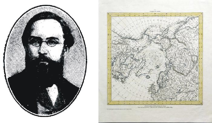
August Heinrich Petermann (left). Map of the Arctic published around 1860 (right).
August
Heinrich Petermann (1822-1878) was a German cartographer and geographer. In 1854
he was appointed as director of the geographical institute of Justus Perthes in
Gotha (Germany), and in 1855 founded the famous geographical journal Petermanns
Mittellungen, which existed until 2004.
August
Petermann’s main geographical interest was two-fold: The geography of the
interior of Africa, and that of the North Polar regions.
In 1852, August Petermann's belief in the ice-free central part of the Arctic Ocean made him propose that search expeditions for the lost Franklin expedition should sail north between Spitsbergen and Novaya Zemlya, thereby taking a shortcut to the open, navigable Polar Sea, providing easy access to the areas north of the American continent.
Petermann
was appointed as royal geographer by Queen Victoria. He later died by his own
hand at Gotha on September 25, 1878.
Click here to jump back to the list of contents.
1824:
Joseph Fourier suggests an explanation of global temperature
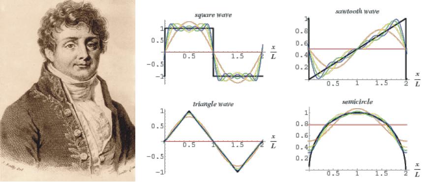
Joseph Fourier (left), and an example of his now widely used mathematical technique in which complex functions can be represented by a series of sines and cosines (right).
Jean Baptiste Joseph Fourier (1768-1830) is best known today for his Fourier series, a widely used mathematical technique in which complex functions can be represented by a series of sines and cosines. The study of Fourier series can be considered a branch of Fourier analysis. Although being a great mathematician, most of Fourier's contemporaries knew him as an administrator, Egyptologist, and scientist. His fortunes rose and fell with the political tides. He was a mathematics teacher, friend of Napoleon, a secret policeman, governor of Egypt, prefect of Isère and Rhône, a political prisoner, baron, outcast, and perpetual member and secretary of the French Academy of Sciences (Fleming 1998).
Fourier had a keen interest in heat and heat conduction, and presumably considered himself the Newton of heat: "The principle of heat penetrates, like gravity, all objects and all of space, and it is subject to simple and constant laws" (Fleming 1998). The question of terrestrial temperature was on Fourier's mind as early as 1807, when he wrote on the unequal heating of the globe. He later conducted a series of experiments on daytime heating by the Sun, and on nighttime cooling.
In 1824 Joseph Fourier read a paper to the Académie Royale des Science, which was published the same year in the Annales de Chimie et de Physique. The 1924 paper relied heavily on previous publications by Fourier in 1807, 1817 and 1822. In 1837 his famous 1824 paper was translated into English and published in the American Journal of Science (Fleming 1998). In his discussion of the temperature of space, Fourier pointed out that the thickness of the atmosphere and the nature of the surface determine the average temperature of a planet. Fourier did not use the term "greenhouse" in his 1824 publication, but he described the temperature of the Earth as being controlled by three distinct sources: (1) solar radiation, which was considered unequally distributed over the year and which produces the diversity of climates; (2) the temperature communicated by the interplanetary space irradiated by the light from innumerable stars; and (3) heat from the interior of Earth, assumed to be remaining from its formation (Fleming 1998).
In section (2) on the temperature of space and its assumed effects on the surface temperature of Earth Fourier presented most of his comments on the heating of the atmosphere. He points out that both the thickness of the atmosphere and the nature of the planet surface controls the average surface temperature. It is here that Fourier comments on what today might be considered as an early version of the greenhouse theory by stating: "The temperature [of the Earth] can be augmented by the interposition of the atmosphere, because heat in the state of light finds less resistance in penetrating the air, than in repassing into the air when converted into non-luminous heat" (Fleming 1998). Fourier is here making reference to experiments done on a series of glass plates enclosing a vacuum, and glass plates separated by atmospheric air, observing that the latter experimental setup retained solar heat more efficiently, but also that all experiments were sensitive to the distances between the glass surfaces.
Fourier's experiment was related to a glass enclosure, and he was interested in the idea that such an air filled glass enclosure could trap and store 'dark light' (infrared), making it a kind of radiant battery. By this, Joseph Fourier early recognised the importance of the planetary atmosphere for the average surface air temperature, although the glass enclosure model is far from a realistic analogue for the planet's atmosphere. There also little doubt that he considered the temperature of space being more important than the atmospheric effect as a control on the average surface temperature of planet Earth.
Later scientific contributions to the understanding of global climate dynamics can be found by clicking here, here, here, here and here.
Click here to jump back to the list of contents.
1826:
The Willey slide in Crawford Notch
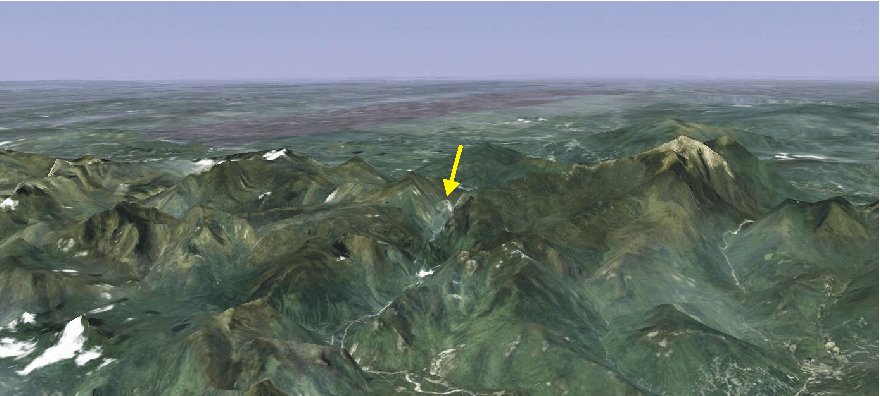
Google Earth illustration showing White Mountains in New Hampshire, USA, looking northwest. The yellow arrow indicates the position of Crawford Notch valley. The high mountain to the right is Mount Washington (1917 m asl).
Since 1803 "The Notch" or "The Pass of the White Mountains" was an important link between northeastern Vermont, northern New Hampshire, and Portland, Maine. Three habitations were located along the road leading through the valley and functioned as inns, one at the northwestern end and one at the southeastern end, and one in between. Especially during the winter months these inns were important for travellers.
In 1825 Samuel Willey Jr. of Bartlett became owner of the central inn, a small one-and-a-half story farmhouse called the Notch House (Ramsey 2003). The house was build in 1792, and was badly in need of repairs. Willey moved his family with five children into the house during the autumn of 1825 and set to work with two hired men to enlarge and make the house secure against the oncoming winter. The winter 1825-1826 went well, and "the Willey House", as it was now called, rapidly acquired a fine reputation as inn among travellers.
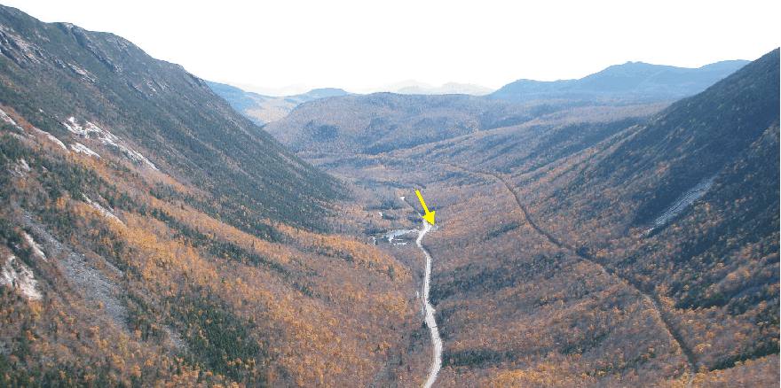
Crawford Notch valley seen from Mt. Willard, looking south-southeast on October 15, 2008. The arrow indicates the position of Willey House. The July mudflow came down the eastern mountain slope (to the left in the picture). The fatal August mudflow came down the western slope (to the right in the picture), towards the house. The valley is a textbook example of a glacial trough valley, channelling ice masses toward southeast during the Quaternary glaciations.
During the first week of July 1826, however, a sudden rainstorm released a mudflow on the eastern mountain slope, opposite to the Willey House (Perley 2001). Missing the barn by about fifteen metres, the debris covered a large area of the road leading along the valley (Ramsey 2003). The mudflow greatly alarmed the Willeys, and Samuel Willey began constructing an emergency shelter a short distance south of the house.
No further events like this occurred during July, and addressing some visitors, Willey reasonably stated, "Such an event, we know, has not really happened here for a very long time past, and another of the kind is not likely to occur for an equally long time to come. Taking things past in this view, then I am not afraid" (Ramsey 2003).
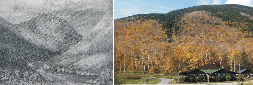
Willey House in Crawford Notch valley before the disaster in 1826 (left) and today (October 14, 2008; right). The original position of the Willey House is just to the right of the large building. The famous New Hampshire autumn colors are at their maximum when the modern photo was taken, and clearly outline of the location of the small, yet fatal, valley in the mountain slope behind the house. The mountain at the head of the valley in the 1826 illustration (left) is Mt. Willard, from where the photo above was taken.
After the rainstorm early July 1825, the weather remained excessively hot and dry into August. The top soil became very dry and vegetation was suffering from lack of water (Ramsey 2003). Then on the afternoon of August 28 rain began to fall all over New Hampshire, and in the evening a heavy rainstorm struck Crawford Notch. During the night high winds and torrential rains lashed the valley, and about 30 large mudflows and landslides were released on both valley slopes (Perley 2001). Much of the road leading up the valley was destroyed.
Nothing was heard from the Willey family, and a rescue party was send towards the Willey House. When they arrived, they found the house standing intact but deserted, and surrounded by debris from a large landslide that had come down directly behind the house, originating higher up the western valley slope, and following a small valley almost directly towards the house (see photo above).
No trace was found of the Willey family and the two assistants, in total nine persons. After several days of intensive search, all but three of the children were located buried by the landslide debris. Presumably they had left the house in the night for gaining safer ground, but were killed by the mudflow and landslide debris. The house itself survived without physical damage, as did the family dog, which apparently was left in the house when the family fled (Ramsey 2003).
Today it is well known among geomorphologists, that just as an excessive wet season may lead to the release of mudflows and landslides in high relief landscapes, so can a dry season in combination with only one heavy rainstorm have an identical effect. During the dry season, soil water is lost by evaporation, and cracks may develop into the ground due to desiccation. During the rainstorm percolation of surface water into the ground may be partly inhibited by the air-filled soil pores, but on a local scale, much water will infiltrate to depth along the open cracks. Such water may rapidly lead to instability on sloping ground, and a landslide or mudflow may be released.
Click here to jump back to the list of contents.
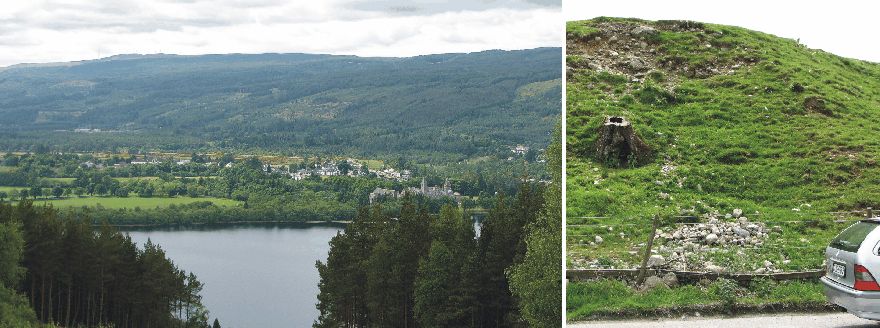
1830-1850:
Famine and depopulation of the Scottish Highlands
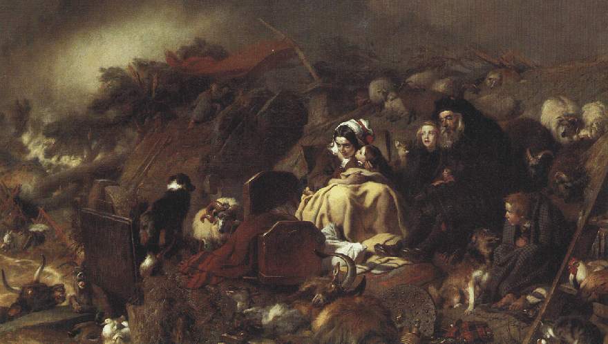
Flood in the Highlands; painting by Sir Edwin Landseer. From the 1820s Landseer painted many scenes from highland life, particularly wildlife.
For political reasons, in the 19th
century liberty was a dangerous word in
A magazine illustration from 1853 showing the loading of a ship with emigrants from the Isle of Skye, northwestern Scotland.
It was, however, the
climate-induced famine of the 1840s that started the real emptying of the
Scottish Highlands. The British Government, which had once tried to find ways of
preventing the depopulation of the
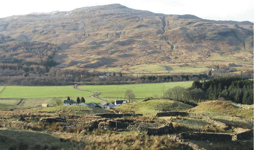
Deserted farm buildings in Trath Filland, 2 km northwest of Crianlarich, western Scotland, February 15, 2008. The location is about 200 m above sea level, and the main modern crop is grass because of the limited number of growing degree days. The former farm is located on a slope facing SW, in an attempt to maximise solar radiation in the afternoon, while fog and low clouds often dominate the meteorological conditions during the morning in this part of Scotland.
Click here to jump back to the list of contents.
1838:
Charles Darwin visits the Parallel Roads of Glen Roy
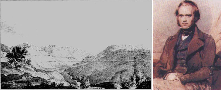
View of the Parallel Roads of Glen Roy, western Scotland (drawing published in Darwin 1839a; left). Compare with Glen Roy scenery June 2006. The young Charles Darwin shortly after returning from the Beagle expedition, about the time when he visited Glen Roy (right).
The
parallel roads of the valley Glen Roy in the western highlands of
In the 19th century,
the Parallel Roads attracted the attention of many early geologists, including
the Reverend William Buckland, James Geikie, Charles Lyell and Joseph Prestwich.
This ensured that the Parallel Roads featured prominently in the rapid
development of geological science and understanding of landforms.
Charles Darwin back
from his famous Beagle expedition (Darwin 1839b)
had great geological interest and therefore visited Glen Roy in June 1838. Next
year he published his findings in the Philosophical Transactions of the Royal
Society (Darwin 1839a), a publication which
later was known as Darwin's "Gigantic Blunder" and which was bitterly
regretted by himself.
Drawing on his recent
findings in South America during the Beagle expedition Darwin argued in detail
that the Parallel Roads of Glen Roy were old shorelines of marine origin. This
was later contradicted by Louis Agassiz’s Glacial theory of 1840 which instead
suggested that the Parallel Roads were shorelines which had been cut by
freeze-thaw processes along the shore of an glacier-dammed lake ice during the
last ice age.
Darwin's ‘Gigantic Blunder’ is interesting to consider, because it illustrates how even the most sophisticated scientific analysis may lead to a completely wrong result, if the contemporary understanding of all relevant processes is not yet fully developed. As such, Darwin's blunder represents a general warning to all engaged in science. Darwin later recognized his grave error, made while he still was a relatively new scientist, and his ‘blunder’ therefore in no way today discredits his otherwise exceptional fine scientific standing.
Glen Roy had the attention of geologists of that time. Two geologists, Sir Thomas Lauder Dick and Dr. MacCullock, had shortly before in separate talks before the Edinburgh Royal Society and The Geological Society of London suggested that the so-called Parallel Roads of Glen Roy were old shorelines, created by a lake dammed by some unknown object at the lower end of the valley. This was simply what their observations and plain common sense told them, but given accepted geological knowledge at that time, they were unable to explain the physical character of the alleged damming object.
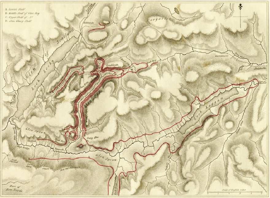
Map showing with red lines the inferred ocean shorelines proposed by Charles Darwin (Darwin 1839a). Glen Roy is the valley in the left centre part of the map. The map covers an area about 35 km from east to west.
The young Charles
Darwin, fresh from his voyage to South America, had been deeply impressed by the
uplift of the Chilean coastline by recent earthquakes (McKirdy
et al. 2007). On this background it is interesting to read and follow
Darwins line of argumentation on the origin of the Parallel Roads of Glen Roy (click
here to read the paper). His line of argumentation demonstrates substantial
self-confidence and attempts of ridiculing scientists holding another
opinion than himself. Here are a few examples:
Page 47: …. it is here, where the slope of the turf-covered hills is unbroken, where there is not a remnant of any projecting mass, that we are compelled by the theory (Dick and MacCullock) to believe that the two enormous barriers stood, which formed Glen Roy into the imaginary Loch Roy.
Page 48: …. In conclusion, therefore, I do not hesitate to affirm, that more convincing proofs of the non-existence of the imaginary Loch Roy could scarcely have been invented, with full play given to the imagination, than those which are marked in legible characters on the face of these hills.
Page 49: …. It
may be safely asserted that more improbable situations could hardly be imagined
in the whole of
Page 55: …. It is a startling assumption to close up the mouth of even one valley by an enormous imaginary barrier; to do this with all would be monstrous. Of such barriers in the district we are considering I need not say there does not exist any trace, nor need I repeat what I have already said against so vain a supposition as that they could have been swept away by any great debacle from the sides of those hills, of which the whole alluvial covering has been preserved since the period when the upper shelves formed beaches, without even a remnant of them being left.
Webmasters note:
The hypothesis on the
former existence of an unknown damming body at the lower end of the valley Glen
Roy clearly did not appeal to Charles Darwin, which several times is seen falling
into the self-made trap of ridiculing his opponents point of view. Instead, he
argued that the Parallel Roads were formed as marine shorelines at a time when the
ocean partly covered
Page 58: ….
From these facts it is certain that there has been a change of level affecting
within recent times the whole central part of Scotland, and of a kind very
similar to that which has been the subject of so much attention in Sweden, where,
according to Mr. Lyell, remains of existing marine animals have been raised to
the height of between 500 and 600 feet above the sea. The change of level in the
case of Sweden is as certainly known to be due to a slow movement of the land,
and not of the water, as it is on the coast of Chile, where a small tract is
violently upraised during an earthquake, the distant parts of the same coast
being unmoved. It would, however, be quite superfluous here to enter into this
question at length, as it has almost ceased to be debateable ground. It may then
be concluded that the supposed great change of level in
Page 79-80: ….Considering
these latter facts, together with the inferences deduced from the phenomena
observed in
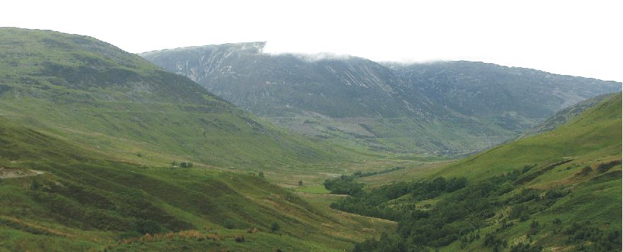
Glen Roy with its Parallel Roads on June 2, 2008, looking north. The horizontal terraces indicate variations in the surface level of a former ice-dammed lake filling the valley, and are arguably the most famous landforms in Great Britain. Three systems of terraces are found, at 350 m, 325 and 260 m above sea level. These different terraces were caused by thickness variations in the glacier blocking the lower part of the valley, controlling the damming ability of the glacier. Glen Roy after 1840 became a key locality for the acceptance of the glacial hypothesis in the 19th century. Compare with drawing above, published in Darwin 1839a.
A few years later, new
geological knowledge on the action of glaciers was introduced when Louis
Agassiz visited
As mentioned above,
Actually, Darwin's so-called 'Gigantic Blunder' was not the fact that he made a flawed interpretation of his observations and arrived at a wrong geological explanation, being carried away as he was by a new and important idea about tectonic uplift. This happens all the time when new interpretations are put forward, and should simply be considered an integral part of scientific progress. His really 'Gigantic Blunder' was the sad fact that he in the process allowed himself to ridicule other fellow scientists, just because he believed (wrongly) himself to be driven by a superior hypothesis and have sufficient physical understanding of all relevant processes in nature.
Today the Parallel
Roads of Glen Roy is seen as a textbook example of shorelines created along an
ice-dammed lake filling the valley, when it about 12.000 years ago became
blocked at the lower end by an advancing glacier. This glacier advance was
caused by a sudden period of climatic cooling at the end of the last ice
age. This climatic reversal is today known as the Younger Dryas or the Greenland
Stadial 1. In Scotland it is locally better known as the Loch Lomond Readvance.
Click here to jump back to the list of contents.
1840:
Louis Agassiz visits the Parallel Roads of Glen Roy
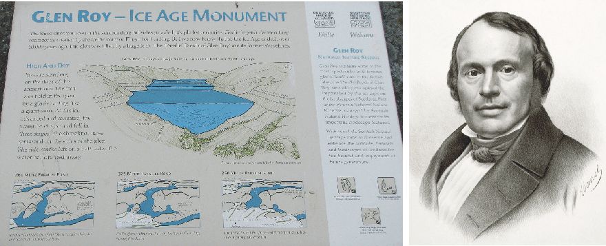
Popular explanation on the origin of the Parallel Roads of Glen Roy as displayed at the main parking lot in Glen Roy, June 2, 2008 (left). The valley Glen Roy is recognized as one of the most important geological sites and arguably the most famous landform in Great Britain. This is the place where the former existence of glaciers outside the Alps for the first time in earnest was recognized by scientists. This, in turn, also lead to the conclusion that Earth had been exposed to large, natural climatic variations. Portrait of Jean Louis Rodolphe Agassiz (right).
Jean Louis Rodolphe Agassiz
(1807-1873) was born in Môtier (now part of Haut-Vully) in the canton of
Fribourg, Switzerland. He studied at the universities of Zürich, Heidelberg and
Munich, extending his knowledge of natural history, especially of botany.
Following a subsequent move to the University of Paris, he became interested in
geology and zoology, especially fish.
In 1832 he was appointed
professor of natural history in the University of Neuchâtel in Switzerland.
Here the fossil-rich slates and limestones attracted his interest, although very
little had been accomplished in the way of scientific study of them previously.
This resulted in a long palaeontological interest in the classification of
fossile fish. Under his inspiring leadership, the University of Neuchâtel soon
became a leading institution for scientific research.
In the meantime, the glaciers of
the Alps had been made an object for scientific studies by naturalists and
scientists like De Saussure, Venetz, Charpentier and Schimper. Both Charpentier
and Schimper had come to the conclusion that fragments of alpine rocks scattered
over the slopes and summits of the Jura Mountains in westernmost Switzerland had
been transported there by glaciers.
This issue attracted the attention of Agassiz, and he had the opportunity to discuss it with both Charpentier and Schimper and made successive journeys to the alpine regions in company with them. He even had a hut constructed upon one of the Aar glaciers in central Switzerland, to investigate the structure and movement of the glacier. Based on this work, Agassiz in 1837 became the first to scientifically propose that the Earth once had been subject to a past ice age with much cooler climate and more extensive glaciers. A bold hypothesis requiring large climatic changes in the past.
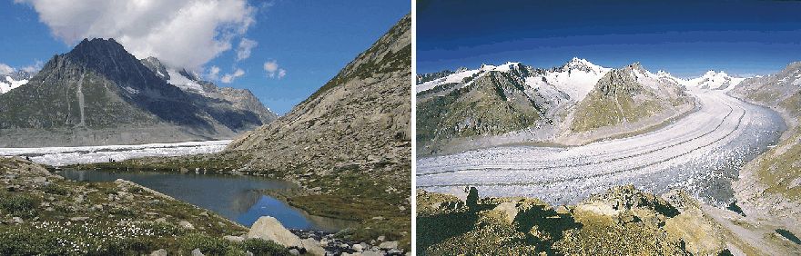
Lake Marjelensee at Grosser Aletschgletscher in Berner Oberland, Switzerland (left). Previously, during the Little Ice Age, Aletschgletscher was thicker and Marjelensee dammed by the glacier and therefore larger and deeper than now. Grosser Aletschgletscher looking NW (right). Lake Marjelensee, including a remnant ice-dammed par, is seen in the lower right corner. The grey zone above the glacier indicate the outline of the glacier surface and Marjelensee around 1850-60, when the present period of glacier recession began in the Alps.
In 1840 Agassiz
published two
volumes entitled Etudes sur les glaciers ("Study on Glaciers").
Here he discussed glacier movement, formation of moraines, and glacier erosion
as demonstrated by striae and roches moutonnées seen in front of many glaciers
in the Alps. As many glaciers at that time was growing, he had no difficulty in
accepting Charpentier's and Schimper's idea that some of the alpine glaciers
previously had
extended across the wide plains and valleys, far beyond their contemporary size.
Agassiz went still farther in his conclusions. He concluded that, in the
relatively recent past, Switzerland had been like Greenland, and that one vast
sheet of ice, originating in the central Alps, had extended over the entire
lowland of northwestern Switzerland, reaching the the Jura mountains.
The publication of this work gave
a fresh impetus to the study of glacial phenomena in all parts of the world. In
addition, it was important to Agassiz to convince the geological community in
Britain, then at the forefront of international geological science. For that reason Agassiz in
1842 visited Scotland.
Following a presentation of his 'outrageous ideas' at a meeting of the British Association in Glasgow, Agassiz departed on a tour of the West Highlands, accompanied by the Rev. William Buckland, professor of Geology and Mineralogy at Oxford University. North-east of Fort Williams, Agassiz visited the already at that time famous Parallel Roads of Glen Roy. A few years before, in 1938, Charles Darwin had interpreted the Parallel Roads as former marine shorelines, suggesting that Scotland since had been exposed to considerable tectonic uplift because of movements of molten rock below the surface. Glen Roy is said to have made a thorough impression on Agassiz. He immediately interpreted the terraces as shorelines formed along a past lake dammed by a now vanished glacier. In Switzerland, he had seen similar terraces around present-day ice dammed lakes, especially at lake Marjelensee at the eastern side of Grosser Aletschgletscher in Berner Oberland (see pictures above).
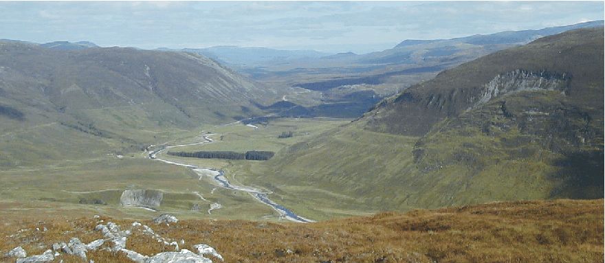
Upper end of Glen Roy, looking ENE on September 3, 2000. The uppermost of the former lake shorelines (350 m asl.) are seen to fit in altitude with the pass at the head of the valley. During this maximum sea level, water from ice-dammed Loch Glen Roy spilled over in the neighbouring Drummin valley to the east, to continue into the Spey drainage system further east. After the disappearance of the lake, a major landslide has taken place on the southern valleyside (to the right), destroying the old shorelines. The age of this landslide is not known, but it has been speculated that this and other landslides in the area were released as permafrost thawed.
After having visited Glen Roy, Agassiz travelled to Fort Augustus 30 km north of Glen Roy, on way to Inverness in NE Scotland, before continuing to Edinburgh. From Fort Augustus Agassiz wrote a letter about his findings to Robert Jameson in Edinburgh, intending that it be published in the Edinburgh New Philosophical Journal (McKirdy et al. 2007). Jameson immediately recognised the significance of Agassiz' discoveries. As the latest issue of the journal was already in press, Jameson passed the letter on to Charles Maclaren, Editor of the still existing newspaper The Scotsman. Maclaren was also a geologist by training, and equally rapidly grasped the importance of Agassiz's letter. Thus on 7 October 1840, under the headline, 'Discovery of former glaciers in Scotland, especially in the Highlands, by Professor Agassiz', the Ice Age was first announced to the wider public.
The ice-dammed lake in Glen Roy and in two other valleys in the Lochaber region of western Scotland were produced by the advance of glaciers from west of the Great Glen (the walley with Loch Ness) up the lower part of Glen Spean. These valleys today drains west, towards the Atlantic Ocean. The advance of glaciers 12,500-12,000 years ago blocked off the drainage outlet, causing Glen Roy, Glen Glory and Glen Spean to fill with water, until spilling over a threshold at 260 m altitude into valleys draining east into the present North Sea area. Further advance of ice up these glens fragmented this large water body into three separate lakes, forcing the Glen Roy lake to empty over a higher col at 325 m, eventually to empty directly into the Spey drainage sustem across a col at the valley head at 350 m altitude. At the glaciers later retreated, each of these three outlets was opened up in turn, presumably starting with a flood event, a jökulhlaup, and then for a time stabilising the level of the lake surface at successively lower altitudes.
Fort Augustus at the south-western end of Loch Ness, looking W on June 2, 2008 (left). The valley bottom is filled with glaciofluvial sediments, deposited by a large river draining meltwater from glaciers further to the SW. A thick layer of the glaciofluvial sediments is very coarse-grained, with individual clasts up to 30-40 cm in size, and may have been derived from a jökullaup generated by sudden drainage of the former ice-dammed lake in Glen Roy (right).
The Parallel Roads of Glen Roy themselves presumably were eroded by a combination of wave action and frost weathering of bedrock at lake level maintained by those of the lowest available outlet possibility. In Glen Roy there are three main shorelines, at 350 m, 325 and 260 m above sea level. At its maximum size the lake in Glen Roy attained a surface area of c. 73 km2 and a maximum water volume of c. 5 km3. Sissons (1979) suggested that, in common with many present-day ice-dammed lakes, this huge body of water would periodically have emptied in a gigantic flood or jökulhlaup, with a discharge of possibly as much as 22,500 m3/s. The earliest such jökulhlaup followed the Great Glen to Inverness in NE Scotland, passing through Loch Ness. At the town Fort Augustus at the SW end of Loch Ness a huge fan of of coarse gravel and stones 7 km2 in area and up to 39 m thick was interpreted by Sissons (1979) as a jökulhlaup deposit, produced in a few days some time 11,500-12,000 years ago, as a result of the breaching of the ice dam in lower Glen Roy, some 30 km away (see photos above).
Click here to jump back to the list of contents.
1840:
Louis Agassiz visits Blackford Hill in
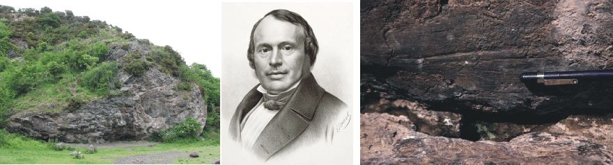
Agassiz Rock
near the south-eastern end of
Blackford Hill in
Two weeks after his visit at Glen Roy, Louis Agassiz arrived in Edinburgh. Agassiz's letter had by now been published in newspaper the the Scotsman, so huge interest was attached to his visit in Edinburgh. A party of local geologists stood ready and took him to inspect the southern slope of Blackford Hill in southern Edinburgh (see picture above), where additional interesting evidence might be at hand.
Blackford
Hill is the remnant of a volcano, dating back in Devonian time (416 million
years ago). This was probably not quite clear to Agassiz, as he was lead to the
place the local geologists looked forward to hear his opinion about. On the
south side of Blackford Hill a steep andesite cliff has been undercut to form a
shallow cave, the rock surfaces of which was polished with peculiar scratches
and grooves.
Agassiz Rock on Blackford Hill rapidly became of considerable significance for the growing acceptance of the glacial hypothesis, since the striations under the rock overhang could not have been produced by icebergs floating in an ocean, the hyphotesis of many contemporary geologists to explain these and similar phenomena. Nor could they have been formed by debris-laden catastrophic deluges or floods as suggested by other contemporary geologists.
Agassiz
himself recognised the high value of his experience in
However, at that time the glacial
hypothesis was still not broadly accepted in the scientific community, and
despite the initial persuasiveness of
Only six years later than the visit of Agassiz in Scotland, in 1846, the pioneering Scottish glaciologists James Forbes published detailed observations on the effects of local glaciers on the Isle of Sky, NW Scotland. His account included the first ever map of an end moraine - that of Coir a'Ghrunnda in the Cullin Hills, clear geomorphological evidence of past climatic changes.
The mid-nineteenth century saw a revolution in geological thinking about the processes that shaped the present landscape, and landscape elements at Glen Roy (see above) and at Blackford Hill in Edinburgh played a key part in this development. Until then, most geologists explained surface landforms and loose deposits in terms of a great submergence, akin to the Biblical Flood. By the end of the century, however, these ideas has been dismissed and it was now generally accepted that glaciers and climatic changes had played a fundamental part in shaping the modern landscape in Europe during the course of repeated glaciations.
Click here to jump back to the list of contents.
1840:
Arctic explorations becomes a national obsession in
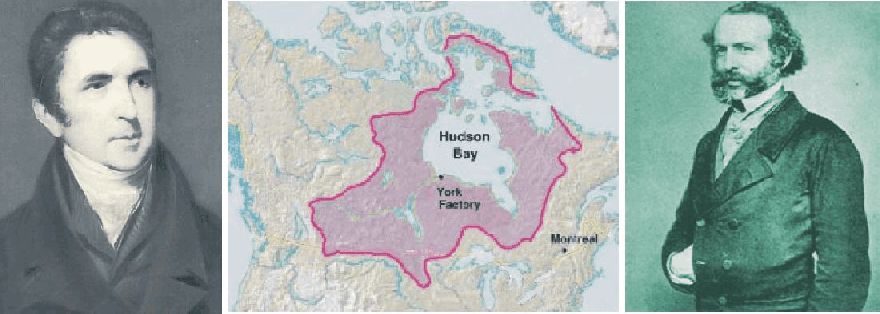
John Barrow, second secretary to the Admiralty (left). Map showing area of Canada where the Hudson's Bay Company was active (centre). John Rae, the Arctic traveller and Hudson's Bay Company doctor, who later solved the fate of the doomed Franklin expedition and found the last navigable link in the Northwest Passage.
By the early 1840s, Arctic
exploration had attained the status of a national obsession in
During the past three and a half
centuries, northern Europeans, lead by
Since the 1570s, when Martin
Frobisher identified two possible
Part of the reason for the
growing interest in Arctic exploration in
John Barrow, second secretary to
the Admiralty, therefore renewed the quest for the
Also, because the
Click here to jump back to the list of contents.
1844-1848:
Vernagtferner again advances into Rofental and ice dammed Rofen ice lake reforms
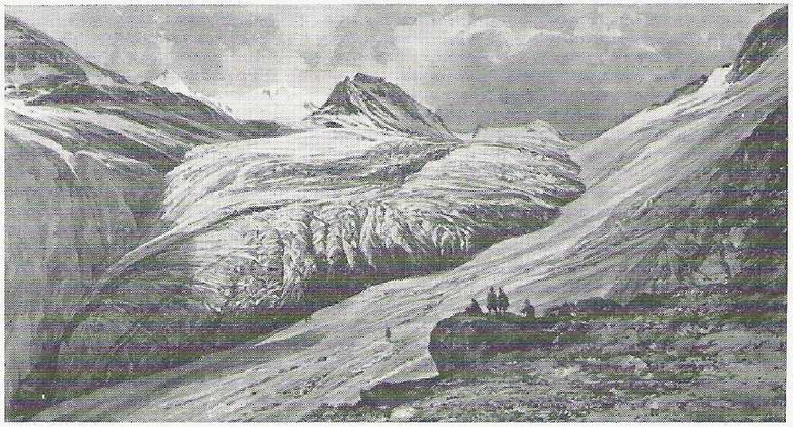
Reproduction of water color by Thomas Ender, showing the advancing Vernagtferner (Ötztaler Alpen, Tirol, Austria) in the early summer of 1844, about 1 km short of the main valley (Rofental). The spot from where this picture iwas made is almost identical to that from where an early photograph of the glacier was taken in 1884, only a little lower into the valley. Heavy crevassing and accelerated movement began shortly afterwards (Hoinkes 1969). The original belongs to the Sammlung Erzherzog Johan.
In the early summer of 1844 the Vernagtferner began advancing (see picture above), and reached the main valley Rofental during spring 1845. By blocking drainage along Rofental, the Rofener ice lake reformed during the spring and summer 1845. The lake lasted for several years, and drained catastrophic on 14 June 1845, 28 May 1847 and 13 June 1848 (Hoinkes 1969).
A vivid description of the catastrophic flooding of the valleys Rofental and Ötztal (further downstream) is given by Stotter (1846). The water, carrying blocks of ice, caused a rise of the level of the River Inn of about 0.6 m even at the city Innsbruck, after having traveled a distance of 102 km in nine hours. The last drainage of the ice dammed lake on 13 June 1848 is reported by Schlagintweit and Schlagintweit (1850).
According to a reconstruction done by Hess (1918), the ice dammed lake in 1848 contained about 3 x 10⁶ m3 water, before the catastrophic drainage on 14 June. At the more severe floodings of 1847 and in 1678 a water volume of about 10 x 106 m3 cam be estimated from the reported dimensions of the lake (Hoinkes 1969).
Following the drainage in 1848, the Vernagtferner began retreating, and although readvances have occured, it never again has been able to block drainage along Rofental.
Click here, here and here to read about previous Little Ice Age advances of the Vernagtferner. Click here, here and here to read about the glacier retreat following the Little Ice Age advances.
Click here to jump back to the list of contents.
1845-1848:
The Franklin Expedition to the Northwest Passage
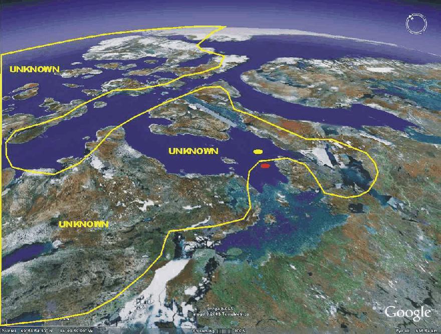
Satellite picture showing the central parts of the Northwest Passage, as known in 1845, when the Franklin Expedition sailed. Direction of view is towards northeast. The yellow dot shows where Erebus and Terror were beset 1846. The red dot shows where they were abandoned April 1848. King Williams Island is seen shortly southeast of the red dot. Greenland is seen in the far distance. Picture source: Google Earth.
In September 1843 James Clark Ross returned triumphantly with HMS Erebus and HMS Terror from a brilliant three-year voyage of exploration in Antarctic seas, during which the Ross Sea and the Ross Ice Shelf were discovered and named. Their arrival offered John Barrow a last opportunity, before his retirement in 1845 aged eighty, to mount the decisive expedition to find the Northwest Passage.
The Royal British Navy therefore decided to send a well-equipped Arctic
expedition to complete the charting of the
The new British expedition with John Franklin in command was
ordered to gather magnetic data in the Canadian Arctic and to complete a
crossing of the
The expedition was provided with the two sturdy navy ships, HMS Erebus and HMS Terror, just returned from their Antarctic journey. Both ships was build as so-called bomb vessels. Bomb vessels were strongly built in order to withstand the enormous recoil of their 3 ton mortars, and this made them suited to Arctic service. Both ships were equipped with converted railway twenty-horsepower steam engines that enabled the ships to make 4 knots on their own power, and also provided a novel heating device for the comfort of the crew. In addition, a mechanism that enabled the iron rudder and propeller to be drawn into iron wells to protect them from damage when in thick ice. Iron plating was added to their hulls. The expedition brought and three years preserved or tinned preserved food supplies with them. The quality of the canned soups and meat have since been reason for concern, and may have contributed to the sad outcome of the expedition. Captain James Fitzjames, was given command of HMS Erebus while Captain Francis Crozier was named executive commander and commander of HMS Terror.
Being well aquainted with Erebus and Terror from his Antarctic expedition, James Ross thought that the two ships were to big for the planned operation, and was convinced the expoedition would fail. No one, least of all Franklin himself, listened to Ross.
The Franklin Expedition set sail
Sir John Franklin (left). The note found by McClintock in May 1859 in a cairn south of Back Bay, King William Island,
describing the fate of the Franklin Expedition until April 1848 (centre left). Relics of Franklin's
expedition brought back by John Rae in 1854 (centre right). Captain Crozier of
the Terror, Franklin's second in command (right).
The remaining part of the summer 1845 was used exploring the
Wellington Channel northwest of
Presumably
Terror and Erebus were rapidly beset in the thick ice in the southern part of McClintock Channel. Their twenty-horsepower steam engines were no match for meter-thick sea ice. Not surprisingly, the multiyear ice did not melt the following summer 1847, and both ships had to be abandoned in April 1848. Sir John Franklin himself died in June 1847. A desperate attempt to walk and sail to safety in the south with smaller boats was attempted, but in vain. No members of the expedition survived.
A number of rescue expeditions were organized. The German geographer August Petermann in 1852 proposed that a search expedition should be send northwards through 'the wide opening' between Spitsbergen and Novaya Zemlya which 'probably offers the easiest and most advantageous entrance into the open, navigable Polar Sea, and perhaps the best route for the search after Sir John Franklin' (Brown 1858).
The Hudson's Bay
Company doctor John
Rae was, however, in 1854 was the first to collect evidence and information from local
Inuit’s pointing to the fate of the
Captain Leopold McClintock commanded one of the rescue expeditions and later in a book published about his voyage wrote (McGoogan 2001):
Had Sir John Franklin
known that a channel existed eastward of King William Land (so named by Sir John
Ross), I do not think he would have risked the besetment of his ships in such
very heavy ice to the westward of it; but had he attempted the northwest passage
by the eastern route, he would probably have carried his ships safely through to
Behring’s Straits. But Franklin was furnished with charts which indicated no
passage to the eastward of King William’s Land, and made that land (since
discovered by Rae to be an island) a peninsula attached to the continent of
North America; and he consequently had but one course open to him, and that the
one he adopted.
In many respects John Rae can be said to have discovered the
final link in the only
Click here to jump back to the list of contents.
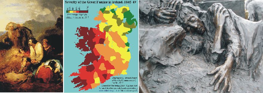
The Discovery of the Potato Blight in Ireland, painting by Daniel McDonald, c. 1847 (left). Map showing the severity of the Irish famine as the part of the the total population which had to receive rations; scale 0-100%. By courtesy of www.irelandstory.com (centre). Memorial for the Irish famine (right).
The Industrial
Revolution never really affected
From 1815 there was
intense population growth in
Potato blight was far
from unknown in
The famine began in
1845 with the blighting and failures of the potato crop, the peoples' chief
means of sustenance. Presumably, the cool
and wet summers of the Irish climate at presumably helped spread the blight.
The potato blight fungus, phytophthora
infestans, attacked potatoes making them
rotten and inedible. After the blight struck in 1845, more potatoes than ever
were planted that spring because people did not expect the blight to strike
again. But there was an even worse failure in 1846 and even more so in 1847,
when suffering reached its climax (MacManus 1944).
There was also famine in
Hard winters
contributed to the disaster. The exceptionally hard winter
1847 made health conditions even worse for undernourished poor people living in primitive
houses with limited possibilities of heating. A typhus epidemic killed tens of
thousands, including wealthier people as the towns were now also affected.
Actually, the 1847 harvest was not as heavily affected by blight as the previous
years, but too few potatoes had been planted so the Famine continued. In 1848
the blight returned, and outbreaks of cholera were reported. In 1849 the potato
crop failed again and famine was accompanied by more cholera outbreaks
Meanwhile, as is often
the case in time of crisis, people formulated their own explanations for the
blight. It was suggested that static electricity in the air resulting from the
newly arrived locomotive trains had caused the disaster. Others reasoned that 'mortiferous
vapors' from volcanoes emanating from the centre of the earth might have done
it. The great Laki
eruption 1783-1784 was still relatively fresh in peoples memory. Some Catholics viewed the crisis in religious terms as Divine punishment for
the "sins of the people" while others saw it as Judgment against
abusive landlords and middlemen. The British government was accused of genocide
by the Irish and even of instigating an "Irish holocaust". In return the
Irish were accused of marrying too early and having too many children.
Comparison with other
modern and contemporary famines establishes beyond any doubt that the Irish
famine 1845-1848 was proportionally much more destructive of human life than the
vast majority of famines in modern times, killing about one-eighth of the entire
Irish population. Altogether, about a million people in
The Irish famine was
probably the worst disaster in